Land At Lords Lot, Crosthwaite, Kendal, Cumbria
- Land size
- 136.35 acres
Key Features
- Ring fenced block of upland meadow and grazing land benefitting from good access .
- Commanding spectacular views towards the Winster Valley & Lakeland Fells.
- High biodiversity value and nature interest, supporting a rich mosaic of habitats with strong ecological and nature conversation interest.
- Rich in vegetation and nature species.
- Exceptional amenity value and a fantastic opportunity for sporting pursuits.
- Significant potential for enhancement through a wood pasture or rewilding-style management scheme, with scope for Biodiversity Net Gain (BNG) unit creation, only four miles from Windermere and Kendal.
- Within the Lake District National Park [a UNESCO World Heritage Site].
Description
A superb opportunity to purchase sound grazing and amenity land Extending to 136.35 acres (55.18 hectares) with spectacular views, situated close to Crosthwaite within the Lake District National Park (a UNESCO World Heritage Site),
offering a wonderful opportunity for environmental opportunities.
Particulars
An outstanding block of upland pasture extending to 136.35 acres (58.18 hectares). The land rises from approximately 55 metres above sea level at the western entrance to the summit of Lord’s Lot at around 205 metres above sea level, affording exceptional panoramic views across the Winster Valley and towards the Lake District Fells.
Access is available by vehicle via a stoned shared access track (marked brown on the Sale Plan. A public footpath crosses the land, and the entire parcel is designated as open access land under the Countryside and Rights of Way Act 2000.
The land comprises species-rich grassland and scrub, with notable areas of heather and bilberry, interspersed with rocky outcrops. It has been identified by Natural England as supporting habitat for the fritillary butterfly, underlining its ecological importance. The land is considered to be of high biodiversity and nature conservation interest, although it is not subject to any statutory environmental designations, offering flexibility for future conservation-led land management initiatives.
The land offers great sporting potential, with sporting rights included on both lots. The land has previously been used for pheasant shooting, clay pigeon shooting and deer stalking but there are no existing agreements in place.
Directions
From the centre of the village of Crosthwaite head west along Totter Bank, then take the turning on the right onto Rickettrea, signposted Crook and Starnthwaite. Continue for approximately 400m, then take the right hand fork, continuing to follow signs to Crook and Starnthwaite. After approximately 150m the stone track providing access can be found on the right (with the land situated approximately 550m along this track on the left).
Location
The land is situated to the north of the village of Crosthwaite in South Cumbria. It is approximately four miles west of Kendal and four miles east of Windermere.
Grid Reference: SD441922
What3Words: vote.condiment.tortoises
Services
Environmental Surveys
Environmental surveys have been carried out on the land, which have revealed a range of unique species. The vegetation species include sphagnum moss, marsh cinquefoil, tormentil and square gooseneck moss.
Surveys have also revealed a range of unique bird species, including raven, great spotted woodpecker and European stonechat.
Soils
The land is freely draining, and soils are acidic and loamy over rock.
Tenure/Possession
Freehold. Vacant possession on completion.
Wayleaves and Easements
The properties are sold subject to and with the benefit of any existing easements, rights, wayleaves and rights of way whether or not specifically mentioned in these particulars.
Stewardship Schemes
The land is in the vendor’s Sustainable Farming Incentive Agreement but will be removed from this as soon as possible on completion of the sale. It is not subject to any other environmental schemes at present but would lend itself to Countryside Stewardship and in particular, the wood pasture option. Preliminary discussions have been had with Natural England about this.
Current payment rates* are as follows:
£544 per ha-woodland pasture creation
£146 per ha—keeping native breeds on grazed habitats
*We suggest that interested parties make their own enquiries regarding this.
Boundaries
As far as the vendor is aware the responsibilities for the boundaries are shown on the sale plan by an inward or outward facing “T” mark. Where no mark is shown, no further information is available.
Sporting Rights
The sporting rights are included with the property insofar as they are owned by the Vendor.
Sale Plans
The Sale Plan has been prepared by the Selling Agent for the convenience of the prospective purchasers. It is deemed to be correct, but any error, omission or misstatement shall not affect the sale. Purchasers must satisfy themselves as to accuracy.
Services
Natural water supplies.
Local Authority
Westmorland & Furness Council. Tel No. .
Planning Authority
Lake District National Park. Tel No: .
Method of Sale
The property is offered for sale by private treaty.
Viewing Arrangements
Sporting Rights
The sporting rights are included with the property insofar as they are owned by the Vendor.
Sale Plans
The Sale Plan has been prepared by the Selling Agent for the convenience of the prospective purchasers. It is deemed to be correct, but any error, omission or misstatement shall not affect the sale. Purchasers must satisfy themselves as to accuracy.
Services
Natural water supplies.
Local Authority
Westmorland & Furness Council. Tel No. .
Planning Authority
Lake District National Park. Tel No: .
Method of Sale
The property is offered for sale by private treaty.
Viewing Arrangements
Viewing is permitted at any reasonable time with possession of a set of these particulars. Anyone viewing the land does so at their own risk and is politely asked to ensure that the gates are securely closed when leaving the land. Tel No: , Option 3.
Map Location
Property details
- Tenure
- Freehold
- Council Tax Band
- TBC
- Date Posted
- 2026-02-04
Market Value Analysis
Compared with 14 Farmland & Pasture listings in North West England (100+ acres).
Utilities & Restrictions
Utilities
- Electricity
- Ask Agent
- Water
- Ask Agent
- Heating
- Ask Agent
- Broadband
- Ask Agent
- Sewerage
- Ask Agent
Rights & Restrictions
- Public Rights of Way
- Ask Agent
- Private Rights of Way
- Ask Agent
- Listed Property
- Ask Agent
- Restrictions
- Ask Agent
Listed status, conservation areas and planning constraints for this location are in the full report.
Property Features
- Accessibility
- Ask Agent
- Parking
- Ask Agent
- Garden
- Ask Agent
Beyond the particulars: planning activity, flood history, heritage and ground risks, checked for this exact spot.
Connectivity
Broadband
Fastest speed available at this postcode
1.8 Gbps
Gigabit full fibre · available to 86% of premises
Suitable for
- 4K streaming on every screen
- Full-time home working
- Online gaming & big downloads
Mobile signal
Predicted 4G and 5G signal; indoor signal depends on building materials.
Ofcom Connected Nations postcode-level predictions. Speeds and signal are modelled, not measured, and vary between addresses and providers.
Signal is the easy part. Planning activity, flood history and protected designations here are in the full report.
Nearest Schools
Primary
- Crosthwaite CofE School929 metresNo Ofsted rating
- Ages
- 3 to 11
- Pupils
- 109
- Type
- Voluntary aided school
- Faith
- Church of England
- St Martin & St Mary Church of England Primary School3.9 milesNo Ofsted rating
- Ages
- 2 to 11
- Pupils
- 336
- Type
- Voluntary aided school
- Faith
- Church of England
- Goodly Dale Primary School3.9 milesOfsted: Good *
- Ages
- 3 to 11
- Pupils
- 77
- Type
- Community school
- St Cuthberts Catholic Primary School, Windermere4 milesOfsted: Requires improvement
- Ages
- 3 to 11
- Pupils
- 40
- Type
- Academy converter
- Faith
- Roman Catholic
- Staveley CofE School4.3 milesOfsted: Good *
- Ages
- 4 to 11
- Pupils
- 79
- Type
- Voluntary controlled school
- Faith
- Church of England
Secondary
- Kirkbie Kendal School4.8 milesNo Ofsted rating
- Ages
- 11 to 18
- Pupils
- 1,029
- Type
- Academy converter
- The Queen Katherine School5.2 milesOfsted report card · May 2026
- Ages
- 11 to 19
- Pupils
- 910
- Type
- Academy converter
- The Lakes School5.4 milesOfsted: Good
- Ages
- 11 to 18
- Pupils
- 445
- Type
- Community school
- Dallam School7.5 milesOfsted report card · Apr 2026
- Ages
- 11 to 18
- Pupils
- 761
- Type
- Academy converter
- John Ruskin School9.2 milesOfsted: Good
- Ages
- 11 to 16
- Pupils
- 247
- Type
- Community school
* Latest graded judgement covers quality of education only; no overall grade was issued under the 2024-25 inspection framework.
Distances are straight-line from the advertised location. Source: the national school registers (DfE, Welsh Government, Scottish Government) and Ofsted.
Schools are just the start: sold prices nearby, planning activity and any flood history are in the full report.
Amenities
Supermarket
GP surgery
Pharmacy
Hospital
Green space
Straight-line distances from the advertised location. Sources: NHS records, Geolytix supermarket locations, OS Open Greenspace and the national trails registers.
The area stacks up? Now check the location itself: planning nearby, protected designations and past flooding.
Getting Around
Nearest station
Nearest bus stop
Typical drive times
Straight-line distances from the advertised location; drive times are typical free-flow times over OpenStreetMap road data, so allow more at peak. Public transport locations from DfT NaPTAN.
Easy to reach matters. So do planning activity, flood history and ground risks: all in the full report.
Flood Risk
Environment Agency open data, checked around the advertised map pin for the listed acreage. Long-term risk counts flood defences; the planning map's flood zones do not. The map pin for this listing marks the postcode area rather than the exact location, so these readings describe the surrounding area. Provided by LandSale, not the listing agent, and not part of the agent's particulars. Risk varies across a holding, so verify before committing.
Rivers and the sea
Planning map: Flood Zone 3, about 40 metres away.
Surface water
Not at the pin: mapped about 40 metres away.
These bandings are the summary. Where this location sits on the flood maps, plus planning activity, heritage and ground risks, is in the full report.
Important notice: Information, maps and tags on this page are drawn from the advertising agent's marketing materials or generated automatically. LandSale has not verified them. Relying on these details is at your own risk, always carry out independent checks before committing to a purchase.
LandSale full disclaimer
Marketing information only - not formal particulars. The details on this website are provided for general guidance and do not constitute an offer or contract. Neither LandSale nor the advertising estate/land agent accepts responsibility for any inaccuracy.
1. Source of information
- Listing content: Core description, asking price, tenure, measurements, photographs and planning history originate from the marketing materials of the advertising estate or land agent. LandSale does not author this content and cannot guarantee its accuracy.
- Automated tags & categorisation: Property type, land-use class, acreage bands and similar labels may be applied by machine-learning models. They are intended as a helpful guide only and may not reflect the property's legal status or permitted use.
- Third-party & enriched data layers: Maps, boundary outlines, planning designations, soil reports, broadband coverage and other environmental or location-based insights are licensed from external suppliers. Such data are supplied “as is", may be incomplete or out of date and are subject to change without notice.
2. Verification required
Prospective purchasers must verify critical matters, including but not limited to planning permission, title boundaries, public rights of way, environmental constraints, acreage, services, access and VAT status, through their own inspections, specialist surveys, legal advisers and the selling agent before relying on the information or entering into any contract.
3. No warranty or liability
LandSale gives no warranty, express or implied, as to the accuracy, completeness or fitness for any particular purpose of the information displayed. LandSale shall not be liable for any loss, damage, cost or expense arising directly or indirectly from any use of or reliance on such information, save where liability may not be excluded by law.
4. Updates & feedback
If you believe any detail on this listing is inaccurate, please let us know. We will investigate and, where appropriate, update the listing or notify the agent.
© LandSale | Version 1.3 - August 2026
Listing agent
H&H Land & Estates, Penrith
1a St. Andrews View Penrith CA11 7YF
Similar properties for sale
- Price
- £500,000
- Size
- 428.53 acres
Harter Fell, Longsleddale, Kendal, Cumbria, Kentmere, Westmorland and Furness LA8 England
Added on 20/07/2026Agricultural Land
- Price
- Guide Price£665,000
- Size
- 81.89 acres
Added on 17/07/2026Agricultural Land
- Price
- Offers in Excess of£675,000
- Size
- 150.29 acres
Apperset, Hawes, Leyburn, North Yorkshire, DL8, Hawes, North Yorkshire DL8 England
Added on 21/05/2026Grazing Land
- Price
- Offers Over£500,000
- Size
- 358.27 acres
Land at, Nether Hesleden, Litton, North Yorkshire, Litton, North Yorkshire BD23 England
Added on 29/01/2026Agricultural Land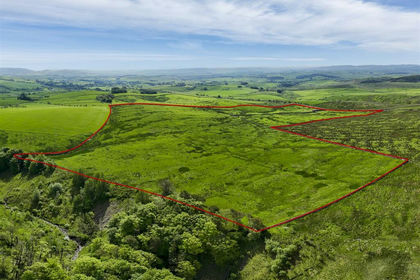
- Price
- Guide Price£680,000
- Size
- 116.31 acres
Airton, Skipton, Kirkby Malham, North Yorkshire BD23 England
Added on 29/01/2026Grazing Land
- Price
- £595,000
- Size
- 322.69 acres
Land At Renwick Fell, Renwick, Penrith, Kirkoswald, Westmorland and Furness CA10 England
Added on 12/06/2026Grazing Land