Sweffling, Nr Saxmundham, Suffolk
- Land size
- 0.23 acres
Description
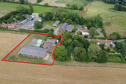
A choice of three impressive building plots, each benefitting from planning permission for a contemporary styled four double bedroom detached house with double garage on individual plots adjoining open agricultural land in the beautiful rural village of Sweffling, within the Alde Valley.
Location
The site is set along Glemham Road, a short distance to the south of the centre of the village of Sweffling. The village has a terrific community feel with events taking place at the village hall and also at the award winning pub, The White Horse. Sweffling is situated amidst gently undulating countryside around the upper reaches of the River Alde. The historic market town of Framlingham lies within 5 miles and has excellent schools in both the state and private sectors, as well as good day-to-day shopping facilities. The town is best known for its fine medieval castle. Saxmundham lies about 4 miles to the east. Here there are Waitrose and Tesco supermarkets and a railway station with trains to Ipswich and, in turn, London’s Liverpool Street station, which take just over the hour. The Heritage Coast at Aldeburgh lies some 9 miles away, with Dunwich and the Minsmere Bird Reserve being about 12 miles to the east.
Directions
From the centre of the village travel in a southerly direction along the Glemham Road. After approximately half a mile the development site will be found on the right hand side.
For those using the What3Words app: ///spotted.wide.embellish
Description
A hybrid Outline Planning Permission was granted by East Suffolk Council on 19th May 2023 - Planning Permission Reference DC/22/3124/OUT for the redevelopment of the White House Barns site to create three impressive new dwellings, following which all reserved matters and conditions were discharged/approved. These plots are being offered for sale separately as an exciting opportunity for a self-builder to create a stunning, bespoke new homes in the beautiful rural village of Swelling within the Alde Valley. Each of the proposed houses is of a similar design, and all extending to over 2,100 sq ft (198 sqm). The styling is contemporary including larch cladding, London Stock red facing brick work, natural slate roofing and aluminium windows in dark grey.
Extracts of the consented layout plan, elevations and floorplans are included within these particulars, but are for indicative purposes only. A summary of the proposed plots is below.
Plot 1 - 0.23 acre - 2,130 sq ft - 198 sqm - £195,000
Plot 2 - 0.27 acre - 2,262 sq ft - 210 sqm - £225,000
Plot 3 - 0.32 acre - 2,130 sq ft - 198 sqm - £220,000
Design & Build Opportunity
The planning permission for this development provides for the proposed dwellings to be phased. This would allow for purchasers to largely ‘design and build’ their own individual property with the vendors dealing with the demolition of the existing buildings on site and installation of the access road, highway access and service connections. Any significant departure from the approved plans will require consultation with the local planning authority. The vendor and their consultant developer can offer a ‘turnkey’ development package and manage the construction of the proposed dwelling to completion if required.
CIL
Any future detailed planning permission will be subject to the local planning authority’s Community Infrastructure Levy (CIL). At this stage, with it being an outline planning permission or a hybrid outline planning permission, there is no CIL Liability Notice and that amount/figure will only be confirmed once detailed planning permission has been approved. However, on the basis that the plot is purchased and completed by a self-builder/owner-occupier, then we understand that exemption from CIL will be applicable. Any detailed enquiries relating to CIL should be referred to the local planning authority, East Suffolk Council; .
Services
The vendors will arrange for mains electricity and water to be connected to the edge of each plot being purchased. It is anticipated that drainage will be via a new sewage treatment plant located within the extent of each plot.
Development Timescale
Currently the site still comprises a range of former agricultural barns. It is the intention of the vendor to demolish and clear these buildings as well as installing the aforementioned access road, Highway access and service connections between exchange of contracts and completion of the initial plot sale.
Local Authority
East Suffolk Council; East Suffolk House, Station Road, Melton, Woodbridge, Suffolk IP12 1RT;
Tel:
Architects
High Design Consultants Ltd, 15 Peel Street, London W8 7PA; Tel:
Email:
Viewing
By prior appointment with the selling agents.
NOTES
1. Every care has been taken with the preparation of these particulars, but complete accuracy cannot be guaranteed. If there is any point, which is of particular importance to you, please obtain professional confirmation. Alternatively, we will be pleased to check the information for you. These Particulars do not constitute a contract or part of a contract. All measurements quoted are approximate. The Fixtures, Fittings & Appliances have not been tested and therefore no guarantee can be given that they are in working order. Photographs are reproduced for general information and it cannot be inferred that any item shown is included. No guarantee can be given that any planning permission or listed building consent or building regulations have been applied for or approved. The agents have not been made aware of any covenants or restrictions that may impact the property, unless stated otherwise. Any site plans used in the particulars are indicative only and buyers should rely on the Land Registry/transfer plan.
2. The Money Laundering, Terrorist Financing and Transfer of Funds (Information on the Payer) Regulations 2017 require all Estate Agents to obtain sellers’ and buyers’ identity.
May 2026
Map Location
Property details
- Tenure
- Freehold
- Council Tax Band
- Ask Agent
- Date Posted
- 2026-02-27
Utilities & Restrictions
Utilities
- Electricity
- Ask Agent
- Water
- Ask Agent
- Heating
- Ask Agent
- Broadband
- Ask Agent
- Sewerage
- Ask Agent
Rights & Restrictions
- Public Rights of Way
- Ask Agent
- Private Rights of Way
- Ask Agent
- Listed Property
- Ask Agent
- Restrictions
- Ask Agent
Listed status, conservation areas and planning constraints for this location are in the full report.
Property Features
- Accessibility
- Ask Agent
- Parking
- Parking Available
- Garden
- Ask Agent
Beyond the particulars: planning activity, flood history, heritage and ground risks, checked for this exact spot.
Connectivity
Broadband
Fastest speed available at this postcode
1 Gbps
Gigabit full fibre · available to 63% of premises
Suitable for
- 4K streaming on every screen
- Full-time home working
- Online gaming & big downloads
Mobile signal
Predicted 4G and 5G signal; indoor signal depends on building materials.
Ofcom Connected Nations postcode-level predictions. Speeds and signal are modelled, not measured, and vary between addresses and providers.
Signal is the easy part. Planning activity, flood history and protected designations here are in the full report.
Nearest Schools
Primary
- Saxmundham Primary School1.8 milesOfsted: Good
- Ages
- 3 to 11
- Pupils
- 252
- Type
- Academy converter
- Kelsale Church of England Voluntary Controlled Primary School2.2 milesNo Ofsted rating
- Ages
- 4 to 11
- Pupils
- 166
- Type
- Voluntary controlled school
- Faith
- Church of England
- Benhall St Mary's Church of England Primary School2.3 milesNo Ofsted rating
- Ages
- 4 to 11
- Pupils
- 77
- Type
- Academy converter
- Faith
- Church of England
- Snape Primary School4 milesNo Ofsted rating
- Ages
- 2 to 11
- Pupils
- 103
- Type
- Academy converter
- Framlingham Sir Robert Hitcham's Church of England Voluntary Aided Primary School4.4 milesOfsted: Good
- Ages
- 3 to 11
- Pupils
- 311
- Type
- Voluntary aided school
- Faith
- Church of England
Secondary
- Thomas Mills High School & Sixth Form4.9 milesOfsted: Good
- Ages
- 11 to 18
- Pupils
- 1,056
- Type
- Academy converter
- Alde Valley Academy6.2 milesOfsted: Requires improvement
- Ages
- 11 to 16
- Pupils
- 645
- Type
- Academy sponsor led
- Stradbroke High School9.8 milesNo Ofsted rating
- Ages
- 11 to 16
- Pupils
- 353
- Type
- Academy converter
- Farlingaye High School9.9 milesOfsted report card · May 2026
- Ages
- 11 to 18
- Pupils
- 1,861
- Type
- Academy converter
- Debenham High School12 milesOfsted: Good
- Ages
- 11 to 16
- Pupils
- 714
- Type
- Academy converter
- Faith
- Church of England
Distances are straight-line from the advertised location. Source: the national school registers (DfE, Welsh Government, Scottish Government) and Ofsted.
Schools are just the start: sold prices nearby, planning activity and any flood history are in the full report.
Amenities
Supermarket
GP surgery
Pharmacy
Hospital
Green space
Straight-line distances from the advertised location. Sources: NHS records, Geolytix supermarket locations, OS Open Greenspace and the national trails registers.
The area stacks up? Now check the location itself: planning nearby, protected designations and past flooding.
Getting Around
Nearest station
Nearest bus stop
Typical drive times
Straight-line distances from the advertised location; drive times are typical free-flow times over OpenStreetMap road data, so allow more at peak. Public transport locations from DfT NaPTAN.
Easy to reach matters. So do planning activity, flood history and ground risks: all in the full report.
Flood Risk
Environment Agency open data, checked around the advertised map pin for the listed acreage. Long-term risk counts flood defences; the planning map's flood zones do not. Provided by LandSale, not the listing agent, and not part of the agent's particulars. Risk varies across a holding, so verify before committing.
Rivers and the sea
Planning map: Flood Zone 1.
Surface water
Not at the pin: mapped about 20 metres away.
These bandings are the summary. Where this location sits on the flood maps, plus planning activity, heritage and ground risks, is in the full report.
Important notice: Information, maps and tags on this page are drawn from the advertising agent's marketing materials or generated automatically. LandSale has not verified them. Relying on these details is at your own risk, always carry out independent checks before committing to a purchase.
LandSale full disclaimer
Marketing information only - not formal particulars. The details on this website are provided for general guidance and do not constitute an offer or contract. Neither LandSale nor the advertising estate/land agent accepts responsibility for any inaccuracy.
1. Source of information
- Listing content: Core description, asking price, tenure, measurements, photographs and planning history originate from the marketing materials of the advertising estate or land agent. LandSale does not author this content and cannot guarantee its accuracy.
- Automated tags & categorisation: Property type, land-use class, acreage bands and similar labels may be applied by machine-learning models. They are intended as a helpful guide only and may not reflect the property's legal status or permitted use.
- Third-party & enriched data layers: Maps, boundary outlines, planning designations, soil reports, broadband coverage and other environmental or location-based insights are licensed from external suppliers. Such data are supplied “as is", may be incomplete or out of date and are subject to change without notice.
2. Verification required
Prospective purchasers must verify critical matters, including but not limited to planning permission, title boundaries, public rights of way, environmental constraints, acreage, services, access and VAT status, through their own inspections, specialist surveys, legal advisers and the selling agent before relying on the information or entering into any contract.
3. No warranty or liability
LandSale gives no warranty, express or implied, as to the accuracy, completeness or fitness for any particular purpose of the information displayed. LandSale shall not be liable for any loss, damage, cost or expense arising directly or indirectly from any use of or reliance on such information, save where liability may not be excluded by law.
4. Updates & feedback
If you believe any detail on this listing is inaccurate, please let us know. We will investigate and, where appropriate, update the listing or notify the agent.
© LandSale | Version 1.3 - August 2026
Listing agent
Clarke and Simpson, Framlingham
Well Close Square, Framlingham, IP13 9DU
Similar properties for sale
- Price
- From£195,000
- Size
- 0.23 acres
Sweffling, Nr Saxmundham, Suffolk, Swefling, Suffolk IP17 England
Added on 27/02/2026Building Plot Added on 26/08/2026Development Land
- Price
- Guide Price£225,000
- Size
- 1.25 acres
Added on 28/08/2026Building Plot
- Price
- Guide Price£150,000
- Size
- 1.2 acres
Bridge Farm, Low Road, Mettingham, Bungay, Norfolk NR35, Mettingham, Suffolk NR35 England
Added on 21/09/2026Development Land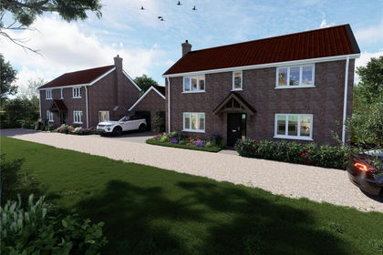
- Price
- Guide Price£150,000
Land Off Loraine Way, Bramford, Ipswich, Suffolk, IP8, Bramford, Suffolk IP8 England
Added on 11/06/2026Building Plot
- Price
- £190,000
Added on 04/04/2026Building Plot
- Price
- £150,000
Added on 24/05/2026Building Plot
- Price
- £155,000
Added on 06/06/2026Building Plot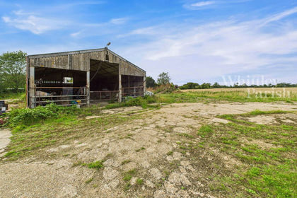
- Price
- Guide Price£150,000
- Size
- 0.38 acres
Short Green, Winfarthing, Diss IP22, Winfarthing, Norfolk IP22 England
Added on 15/05/2026Building Plot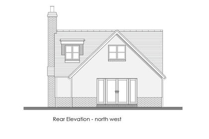
- Price
- Offers in Region of£160,000
Plot Adjacent to The Green, Raydon, Raydon, Suffolk IP7 England
Added on 18/04/2026Building Plot