Land At Clare Farm, Witcham, Ely, Cambridgeshire, CB6 2LN
- Land size
- 31.1 acres
Key Features
- 31.10 (12.58 hectares) of Arable Land
- Available as a whole
- FOR SALE BY PRIVATE TREATY
- Access from a Public Byway
Description
31.10 (12.58 hectares) of Arable Land
Available as a whole
FOR SALE BY PRIVATE TREATY
Access from a Public Byway
Detailed Description
LOCATION
The Land is situated to the North of the Cambridgeshire village of Witcham, approximately 5 miles East of Ely and 6 miles South East of Chatteris, accessed from Wardy Hill Road, a public byway.
what3words: ///storage.relief.selection
Nearest Postcode: CB6 2LN
THE LAND
The Land comprises 31.10 acres (12.58 hectares) of bare arable land. The land is classified as being Grade 3 agricultural land with the soil being of the Evesham 3 series, being lime-rich loamy and clayey soils suitable for cereal cropping and grassland. The land benefits from historical drainage.
The boundaries comprise mature hedgerows with a single point of access from a Byway Open to All Traffic (BOAT), at the Land's south eastern corner.
GENERAL REMARKS AND STIPULATIONS
TENURE & METHOD OF SALE
The Land is being sold freehold with vacant possession upon completion and subject to any rights and easements as described in the particulars of sale.
The Land is offered for sale by way of Private Treaty as a whole.
TITLE
The Land is currently unregistered and pending first registration with the Land Registry.
SERVICES
There are no mains services connected to the Land.
WAYLEAVES, EASEMENTS & RIGHTS OF WAY
A high voltage overhead electricity line crosses the Land on telegraph poles in a south west to north eastern direction.
There are no public rights of way crossing the Land, however the Land is accessed via a public Byway.
There is a mains water pipeline which follows the southern boundary of the Land in an east west direction. Although the Land is not connected to mains water.
SPORTING, MINERALS & TIMBER RIGHTS
The mines and minerals, sporting and timber rights are included in the sale in so far as they are owned.
HOLDOVER
The Vendor reserves the right to holdover for the purposes of harvesting crops until 30th June 2026.
NITRATE VULNERABLE ZONE
The Land is situated within a Nitrate Vulnerable Zone for surface water.
COUNTRYSIDE STEWARDSHIP
The Land has historically been included within a Mid Tier Countryside Stewardship scheme, including grass buffer strips, however this scheme terminated in 2024.
DRAINAGE CHARGES
The Land is subject to Littleport & Downham Internal Drainage Board drainage charges at the prevailing rate.
CROPPING SCHEDULE
Please see the brochure for details of previous cropping.
VALUE ADDED TAX
Should the sale of the Land, or any right attached to it become a chargeable supply for the purposes of VAT, such tax shall be payable by the Purchaser(s) in addition to the agreed sale price.
BOUNDARIES
The Purchaser shall be deemed to have full knowledge of all boundaries and neither the vendors, nor the Vendors' Agent, will be responsible for defining the boundaries nor their ownership.
Any red line boundary shown on the photographs are for illustrative purposes only and do not represent the actual boundary and are not to be relied upon.
PLANS & AREAS
These have been prepared as carefully as possible. The plans and photographs are for illustrative purposes only and although they are believed to be correct, their accuracy cannot be guaranteed.
DISPUTES
Should any disputes arise as to the boundaries or any matters relating to the particulars, schedule or interpretation, the matter will be referred to an Arbitrator to be appointed by the Vendors' Agent.
ANTI MONEY LAUNDERING
In accordance with the most recent Anti Money Laundering legislation, the Purchaser will be required to provide proof of identity and an address to the Vendors Agent once an offer has been submitted and accepted (subject to contract) prior to solicitors being instructed.
VIEWINGS & HEALTH AND SAFETY
The Land may be viewed during daylight hours with a copy of these particulars to hand, subject to prior notification to the Vendor's Agent. Viewing is at your own risk and Viewers should be careful and vigilant whilst on the land. Neither the Vendors' Agent nor the Vendors are responsible for the safety of those viewing the Land nor do they take any responsibility for any losses or damages incurred during inspection.
LOCAL AUTHORITY
East Cambridgeshire District Council
VENDORS' AGENT
Brown&Co, The Fairways, Wyboston Lakes, Great North Road, Wyboston, Bedfordshire, MK44 3AL
Map Location
Property details
- Tenure
- Freehold
- Council Tax Band
- Ask Agent
- Date Posted
- 2026-03-27
Market Value Analysis
Compared with 48 Farmland & Pasture listings in East Anglia (25+ acres).
Utilities & Restrictions
Utilities
- Electricity
- Ask Agent
- Water
- Ask Agent
- Heating
- Ask Agent
- Broadband
- Ask Agent
- Sewerage
- Ask Agent
Rights & Restrictions
- Public Rights of Way
- Ask Agent
- Private Rights of Way
- Ask Agent
- Listed Property
- Ask Agent
- Restrictions
- Ask Agent
Property Features
- Accessibility
- Ask Agent
- Parking
- Ask Agent
- Garden
- Ask Agent
Important notice: Information, maps and tags on this page are supplied by the advertising agent or generated automatically. LandSale has not verified them. Relying on these details is at your own risk, always carry out independent checks before committing to a purchase.
LandSale full disclaimer
Marketing information only - not formal particulars. The details on this website are provided for general guidance and do not constitute an offer or contract. Neither LandSale nor the advertising estate/land agent accepts responsibility for any inaccuracy.
1. Source of information
- Agent-supplied content: Core description, asking price, tenure, measurements, photographs and planning history are uploaded by the appointed agent, who remains solely responsible for their accuracy.
- Automated tags & categorisation: Property type, land-use class, acreage bands and similar labels may be applied by machine-learning models. They are intended as a helpful guide only and may not reflect the property's legal status or permitted use.
- Third-party & enriched data layers: Maps, boundary outlines, planning designations, soil reports, broadband coverage and other environmental or location-based insights are licensed from external suppliers. Such data are supplied “as is", may be incomplete or out of date and are subject to change without notice.
2. Verification required
Prospective purchasers must verify critical matters, including but not limited to planning permission, title boundaries, public rights of way, environmental constraints, acreage, services, access and VAT status, through their own inspections, specialist surveys, legal advisers and the selling agent before relying on the information or entering into any contract.
3. No warranty or liability
LandSale gives no warranty, express or implied, as to the accuracy, completeness or fitness for any particular purpose of the information displayed. LandSale shall not be liable for any loss, damage, cost or expense arising directly or indirectly from any use of or reliance on such information, save where liability may not be excluded by law.
4. Updates & feedback
If you believe any detail on this listing is inaccurate, please let us know. We will investigate and, where appropriate, update the listing or notify the agent.
© LandSale | Version 1.2 - January 2026
Listing agent
Brown & Co, St. Neots
The Fairways, Wyboston Lakes, Great North Road Wyboston St. Neots MK44 3AL
Contact Brown & Co, St. Neots
The Fairways, Wyboston Lakes, Great North Road Wyboston St. Neots MK44 3AL
View agent profileSimilar properties for sale

- Price
- Guide Price£245,000
- Size
- 30.7 acres
Added on 16/06/2026Farmland
- Price
- Guide Price£228,000
- Size
- 76.97 acres
Added on 05/03/2026Agricultural Land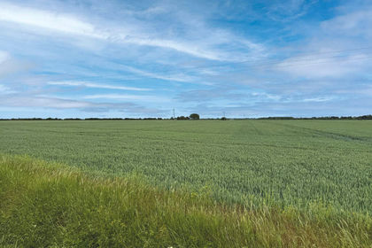
- Price
- Guide Price£210,000
- Size
- 24.43 acres
Land At Haven Drove, Willingham, Cambridgeshire, CB24 8QF, Rampton, Cambridgeshire CB24 8QF England
Added on 04/07/2026Arable Land
- Price
- Guide Price£240,000
- Size
- 22.31 acres
Added on 24/05/2026Farmland
- Price
- £280,000
- Size
- 31.77 acres
Outwell Road, Emneth, Wisbech, Emneth, Norfolk PE14 8BG England
Added on 29/01/2026Agricultural Land
- Price
- £225,000
- Size
- 23.49 acres
High Street, Fincham, King's Lynn, Fincham, Norfolk PE33 9EL England
Added on 29/01/2026Grazing Land
- Price
- Guide Price£270,000
- Size
- 26.89 acres
Arable Land at Winwick, Winwick, Cambridgeshire PE28 5PN England
Added on 25/04/2026Arable Land
- Price
- £215,000
- Size
- 22.6 acres
Arable land at Tydd St Giles, Tydd St. Giles, Cambridgeshire PE13 5LZ England
Added on 24/07/2026Farmland
- Price
- Guide Price£250,000
- Size
- 22 acres
Added on 29/01/2026Grazing Land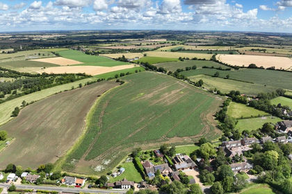
- Price
- Guide Price£230,000
- Size
- 23.67 acres
Added on 17/07/2026Arable Land