London Road, Northchapel
- Land size
- 21.8 acres
Key Features
- Pasture
- Woodland
- Gated Entrance
- Two Useful Fields
- Countryside Views
- Shared Access
- Water
- Approximately 32.05 Acres
- Offered For Sale as a Whole
- Or Pastureland Only
Description
Pastureland only: £375,000 - £400,000
As a whole: £450,000 - £475,000
Well situated pastureland, complemented by a parcel of woodland, extending in total to about 32.05 acres (12.97 hectares). Available as a whole or as pastureland only (about 21.80 acres), the property offers excellent flexibility for a wide range of prospective purchasers.
DESCRIPTION
An attractive parcel of pastureland enjoying far reaching countryside views with excellent access from London Road.
Beautifully positioned in a highly sought after rural location between Haslemere and Petworth, the land is surrounded by open farmland and rolling scenery. Recent management works have included the removal of ash affected by “dieback,” allowing the thriving oak and rejuvenating hazel coppice to flourish.
The land is available as a whole or without the woodland, offering flexibility for a range of purchasers.
AMENITIES
Local: About 1.5 miles from the village of Lurgashall with village shop/Post Office and the Noah’s Ark Inn.
Towns: Petworth is about 5 miles to the south and Haslemere is about 6 miles north west.
Transport: The land is just off the London Road (A283) with easy access to the A3 and A272.
Schools: Northchapel Primary, Fernhurst Primary, Plaistow and Kirdford Primary, Petworth Primary C of E.
ADDITIONAL INFORMATION
Local Authority: Chichester District Council, 1 East Palland, Chichester, West
Sussex, PO19 1TY. Telephone: . Website:
Services (not checked or tested): Water and electricity available. The successful purchaser will be responsible for connection cost.
Rights and Easements: The land is sold subject to and with the benefit of rights, including rights of way, whether public or private, light, support, drainage, water, gas and electricity supplies and any other wayleaves or easements. Two footpaths cross the property.
Plans and Areas: These are based on the Ordnance Survey and are for reference only. The purchaser shall be deemed to have satisfied himself or herself as to their accuracy and any error or misstatement shall not annul the sale or entitle any party to compensation in respect thereof.
Access: A right of way will be granted along the entrance track shown cross hatched brown on the sale plan. Future maintenance will be shared equally between the successful buyer and the vendor.
Links:
Tenure and Possession: Freehold. Land Registry title number: WSX295159 (part).
Restrictive Covenants: The land will be sold subject to the following:
The siting of caravans, mobile homes or chalet style buildings will not be permitted.
Map Location
Property details
- Tenure
- Freehold
- Council Tax Band
- TBC
- Date Posted
- 2026-04-01
Market Value Analysis
Compared with 59 Farmland & Pasture listings in South East England (10+ acres).
Utilities & Restrictions
Utilities
- Electricity
- Ask Agent
- Water
- Ask Agent
- Heating
- Ask Agent
- Broadband
- Ask Agent
- Sewerage
- Ask Agent
Rights & Restrictions
- Public Rights of Way
- Ask Agent
- Private Rights of Way
- Ask Agent
- Listed Property
- Ask Agent
- Restrictions
- Ask Agent
Property Features
- Accessibility
- Ask Agent
- Parking
- Ask Agent
- Garden
- Ask Agent
Important notice: Information, maps and tags on this page are supplied by the advertising agent or generated automatically. LandSale has not verified them. Relying on these details is at your own risk, always carry out independent checks before committing to a purchase.
LandSale full disclaimer
Marketing information only - not formal particulars. The details on this website are provided for general guidance and do not constitute an offer or contract. Neither LandSale nor the advertising estate/land agent accepts responsibility for any inaccuracy.
1. Source of information
- Agent-supplied content: Core description, asking price, tenure, measurements, photographs and planning history are uploaded by the appointed agent, who remains solely responsible for their accuracy.
- Automated tags & categorisation: Property type, land-use class, acreage bands and similar labels may be applied by machine-learning models. They are intended as a helpful guide only and may not reflect the property's legal status or permitted use.
- Third-party & enriched data layers: Maps, boundary outlines, planning designations, soil reports, broadband coverage and other environmental or location-based insights are licensed from external suppliers. Such data are supplied “as is", may be incomplete or out of date and are subject to change without notice.
2. Verification required
Prospective purchasers must verify critical matters, including but not limited to planning permission, title boundaries, public rights of way, environmental constraints, acreage, services, access and VAT status, through their own inspections, specialist surveys, legal advisers and the selling agent before relying on the information or entering into any contract.
3. No warranty or liability
LandSale gives no warranty, express or implied, as to the accuracy, completeness or fitness for any particular purpose of the information displayed. LandSale shall not be liable for any loss, damage, cost or expense arising directly or indirectly from any use of or reliance on such information, save where liability may not be excluded by law.
4. Updates & feedback
If you believe any detail on this listing is inaccurate, please let us know. We will investigate and, where appropriate, update the listing or notify the agent.
© LandSale | Version 1.2 - January 2026
Listing agent
Batcheller Monkhouse, Pulborough
57 Lower Street Pulborough RH20 2AZ
Similar properties for sale

- Price
- Offers in Excess of£450,000
- Size
- 49.72 acres
Crooksbury Woodland, Crooksbury Road, Tilford, Tilford, Surrey GU10 2AW England
Added on 16/04/2026Woodland
- Price
- Guide Price£390,000
- Size
- 10.84 acres
Stoner Hill Road, GU32 1DX, Froxfield and Privett, Hampshire GU32 1DX England
Added on 29/01/2026Pasture
- Price
- Guide Price£400,000
- Size
- 11.65 acres
Bramlands Lane, Woodmancote, Woodmancote, West Sussex BN5 9TG England
Added on 18/06/2026Undeveloped Land
- Price
- Guide Price£380,000
- Size
- 11.88 acres
Added on 29/01/2026Equestrian property
- Price
- Guide Price£350,000
- Size
- 30.9 acres
Mid Street, South Nutfield, Nutfield, Surrey RH1 4HX England
Added on 25/07/2026Farmland
- Price
- Guide Price£290,000
- Size
- 13.42 acres
Land at Popes Lane, Upham, SO32 1JB, Fair Oak and Horton Heath, Hampshire SO32 1HH England
Added on 13/05/2026Grazing Land
- Price
- Guide Price£400,000
- Size
- 13.5 acres
Rocks Road, Uckfield, Fletching, East Sussex TN22 3PT England
Added on 29/01/2026Pasture
- Price
- Offers in Excess of£300,000
- Size
- 15.73 acres
Lewes Road, Piddinghoe, Newhaven, BN9, Newhaven, East Sussex BN9 9AD England
Added on 03/06/2026Development Land
- Price
- Offers in Excess of£395,000
- Size
- 77.2 acres
Broad Lane, Upper Bucklebury, Reading, Berkshire, RG7, Bucklebury, West Berkshire RG7 6QR England
Added on 28/01/2026Woodland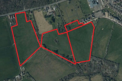
- Price
- £290,000
- Size
- 19.28 acres
Land at Heytesbury Farm, Newport and Carisbrooke, Isle of Wight PO30 5JB England
Added on 29/01/2026Agricultural Land