West Hartley, Blackawton, Totnes
- Bedrooms
- 2
- Bathrooms
- 2
Key Features
- Two-Bedroom Barn Conversion
- Far Reaching Countryside Views
- Rural Yet Well Connected Location
- Single Garage
- Lock Up & Leave
- South West Facing Garden
- Master Bedroom with Ensuite
Description
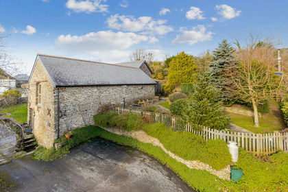
Luscombe Maye are delighted to bring to market this charming two-bedroom semi-detached barn conversion that perfectly blends character and comfort, tucked away in a beautifully peaceful setting. Boasting two parking spaces and two delightful outside areas ideal for entertaining, this is a home designed to be enjoyed both inside and out.
Upon entering, you are welcomed into the contemporary kitchen fitted with an integrated fridge-freezer, small dishwasher and washing machine/tumble drier. There is space for a family dining table and access into the garden. From the central hallway, you step into the heart of the home — a beautifully spacious living room with a beautiful outlook onto the manicured courtyard filled with mature shrubs and flowers. Flooded with natural light and rich in original features, this inviting space also enjoys lovely views out to the far-reaching countryside views. Whether relaxing with family or hosting guests, this room offers warmth, charm, and versatility for all lifestyles. Completing the downstairs accommodation is a WC and under stair storage.
Upstairs, are two well-proportioned bright and airy double bedrooms, and family bathroom. The master bedroom is complemented by an ensuite bathroom fitted with WC, hand basin and shower. The upper floor is a truly special space, with striking original beams running throughout. The family bathroom is beautifully appointed, offering a calm and stylish retreat and elegant design touches, perfectly complementing the character of the home.
Outside, the property enjoys a south west facing secure garden with patio, lawn and picturesque drystone wall as well as charming central courtyard. There are also additional communal areas extending to approximately 6 acres where you can enjoy the tranquil countryside and breath-taking reviews. The property also has a single garage with electric remote-controlled door.
BLACKAWTON
A friendly South Hams village with a lively community, Blackawton lies about halfway between Totnes and Kingsbridge (9 miles) and about five miles from Dartmouth. The historic parish church of St. Michael is the village's principle landmark and Blackawton also has a primary school with an excellent reputation, a large and well-used village hall, a post office, an excellent village run shop and a public house.
Dartmouth is about a 15 minute drive away and has the promenade running the length of the estuary. There are a wide selection of bistros, restaurants, boutiques and specialist shops lining its narrow streets with their long flights of winding steps and intriguing medieval buildings. Kingsbridge is a picturesque market town that enjoys an abundance of amenities and facilities including a wide range of shops, churches, cottage hospital, health centre and a sports centre with indoor swimming pool. The town also has a library, primary school and highly rated secondary school. Totnes, about ten miles away, is known as an Elizabethan town but has much earlier origins with a castle, a wonderful position on the River Dart and a main line railway station. It has a well regarded community college, full range of shops, a weekly market, a wide choice of cultural facilities and a mainline railway station.
FURTHER INFORMATION
To ensure legal compliance, we require our sellers to complete a Property Information Questionnaire or provide a Material Information Guide along with the title document. If available, please scan the QR code or access the additional online material information ( ) . Alternatively, you can contact our team for this information.
Verified material information - see QR code for further details.
Verified Material Information
Council Tax band: D
Tenure: Freehold
Property type: House
Property construction: Barn conversation. Mainly stone.
Energy Performance rating: C
Number and types of room: 2 bedrooms, 2 bathrooms, 1 reception
Electricity supply: Mains electricity
Solar Panels: No
Other electricity sources: No
Water supply: Mains water to Communal water tank in water garage, then to the barns
Sewerage: Sewerage treatment plant
Heating: Mains gas-powered central heating is installed. The system was installed at an unknown date.
Heating features: Double glazing
Broadband: ADSL copper wire
Mobile coverage: O2 - Good, Vodafone - Good, Three - Good, EE - Good
Parking: Garage and Driveway
Building safety issues: No
Restrictions - Listed Building: No
Restrictions - Conservation Area: No
Restrictions - Tree Preservation Orders: None
Public right of way: No
Long-term area flood risk: No
Historical flooding: No
Flood defences: No
Coastal erosion risk: No
Planning permission issues: No
Accessibility and adaptations: None
Coal mining area: No
Non-coal mining area: Yes
Loft access: Yes - insulated and boarded, accessed by: Through smaller bedroom
All information is provided without warranty. Contains HM Land Registry data © Crown copyright and database right 2021. This data is licensed under the Open Government Licence v3.0.
The information contained is intended to help you decide whether the property is suitable for you. You should verify any answers which are important to you with your property lawyer or surveyor or ask for quotes from the appropriate trade experts: builder, plumber, electrician, damp, and timber expert.
LETTINGS
Luscombe Maye also offers an Award Winning Lettings service. If you are considering Letting your own property, or a buy to let purchase, please inform us and we can put you in contact with the Lettings team who would be delighted to discuss our range of bespoke services with you.
VIEWINGS
By appointment with Luscombe Maye, Totnes
DIRECTIONS
What3Words - bookshelf.torn.coached
Map Location
Property details
- Tenure
- Freehold
- Council Tax Band
- D
- Date Posted
- 2026-04-25
Energy Performance Certificate
Energy Efficiency Rating
Based on UK Energy Performance Certificate standards (EU Directive 2002/91/EC)
Running costs are one side. Planning activity, flood history and ground risks for this location are in the full report.
Utilities & Restrictions
Utilities
- Electricity
- Mains
- Water
- Mains
- Heating
- Gas Heating, Double Glazing
- Broadband
- Standard Copper (ADSL)
- Sewerage
- Septic Tank / Private
Rights & Restrictions
- Public Rights of Way
- Ask Agent
- Private Rights of Way
- Ask Agent
- Listed Property
- Ask Agent
- Restrictions
- Ask Agent
Listed status, conservation areas and planning constraints for this location are in the full report.
Property Features
- Accessibility
- Ask Agent
- Parking
- Garage, Driveway
- Garden
- Private Garden, Communal Garden
Beyond the particulars: planning activity, flood history, heritage and ground risks, checked for this exact spot.
Connectivity
Broadband
Fastest speed available at this postcode
16 Mbps
Standard (10-30 Mbps)
Suitable for
- Web & social
- Music streaming
- Standard video calls
Fixed wireless access may also be an option here.
Mobile signal
Predicted 4G and 5G signal; indoor signal depends on building materials.
Ofcom Connected Nations postcode-level predictions. Speeds and signal are modelled, not measured, and vary between addresses and providers.
Signal is the easy part. Planning activity, flood history and protected designations here are in the full report.
Nearest Schools
Primary
- Blackawton Primary School0.8 milesNo Ofsted rating
- Ages
- 2 to 11
- Pupils
- 140
- Type
- Academy converter
- Harbertonford Church of England Primary School2.8 milesNo Ofsted rating
- Ages
- 2 to 11
- Pupils
- 101
- Type
- Academy converter
- Faith
- Church of England
- East Allington Primary School3.2 milesOfsted: Good
- Ages
- 2 to 11
- Pupils
- 80
- Type
- Academy converter
- St John the Baptist Roman Catholic Primary School, Dartmouth3.9 milesNo Ofsted rating
- Ages
- 4 to 11
- Pupils
- 76
- Type
- Academy converter
- Faith
- Roman Catholic
- Dartmouth Academy4 milesOfsted: Good
- Ages
- 3 to 19
- Pupils
- 435
- Type
- Academy sponsor led
Secondary
- Dartmouth Academy4 milesOfsted: Good
- Ages
- 3 to 19
- Pupils
- 435
- Type
- Academy sponsor led
- King Edward VI Community College5.6 milesNo Ofsted rating
- Ages
- 11 to 18
- Pupils
- 940
- Type
- Academy converter
- Churston Ferrers Grammar School Academy6.1 milesOfsted: Good
- Ages
- 11 to 18
- Pupils
- 1,062
- Type
- Academy converter
- Paignton Academy6.6 milesOfsted: Requires improvement *
- Ages
- 11 to 16
- Pupils
- 1,568
- Type
- Academy converter
- Kingsbridge Academy6.9 milesOfsted: Good
- Ages
- 11 to 18
- Pupils
- 1,199
- Type
- Academy converter
* Latest graded judgement covers quality of education only; no overall grade was issued under the 2024-25 inspection framework.
Distances are straight-line from the advertised location. Source: the national school registers (DfE, Welsh Government, Scottish Government) and Ofsted.
Schools are just the start: sold prices nearby, planning activity and any flood history are in the full report.
Amenities
Supermarket
GP surgery
Pharmacy
Hospital
Straight-line distances from the advertised location. Sources: NHS records, Geolytix supermarket locations, OS Open Greenspace and the national trails registers.
The area stacks up? Now check the location itself: planning nearby, protected designations and past flooding.
Getting Around
Nearest station
Nearest bus stop
Typical drive times
Straight-line distances from the advertised location; drive times are typical free-flow times over OpenStreetMap road data, so allow more at peak. Public transport locations from DfT NaPTAN.
Easy to reach matters. So do planning activity, flood history and ground risks: all in the full report.
Flood Risk
Environment Agency open data, checked around the advertised map pin for the listed acreage. Long-term risk counts flood defences; the planning map's flood zones do not. The map pin for this listing marks the postcode area rather than the exact location, so these readings describe the surrounding area. Provided by LandSale, not the listing agent, and not part of the agent's particulars. Risk varies across a holding, so verify before committing.
Rivers and the sea
Planning map: Flood Zone 1.
Surface water
Not at the pin: mapped about 10 metres away.
These bandings are the summary. Where this location sits on the flood maps, plus planning activity, heritage and ground risks, is in the full report.
Important notice: Information, maps and tags on this page are drawn from the advertising agent's marketing materials or generated automatically. LandSale has not verified them. Relying on these details is at your own risk, always carry out independent checks before committing to a purchase.
LandSale full disclaimer
Marketing information only - not formal particulars. The details on this website are provided for general guidance and do not constitute an offer or contract. Neither LandSale nor the advertising estate/land agent accepts responsibility for any inaccuracy.
1. Source of information
- Listing content: Core description, asking price, tenure, measurements, photographs and planning history originate from the marketing materials of the advertising estate or land agent. LandSale does not author this content and cannot guarantee its accuracy.
- Automated tags & categorisation: Property type, land-use class, acreage bands and similar labels may be applied by machine-learning models. They are intended as a helpful guide only and may not reflect the property's legal status or permitted use.
- Third-party & enriched data layers: Maps, boundary outlines, planning designations, soil reports, broadband coverage and other environmental or location-based insights are licensed from external suppliers. Such data are supplied “as is", may be incomplete or out of date and are subject to change without notice.
2. Verification required
Prospective purchasers must verify critical matters, including but not limited to planning permission, title boundaries, public rights of way, environmental constraints, acreage, services, access and VAT status, through their own inspections, specialist surveys, legal advisers and the selling agent before relying on the information or entering into any contract.
3. No warranty or liability
LandSale gives no warranty, express or implied, as to the accuracy, completeness or fitness for any particular purpose of the information displayed. LandSale shall not be liable for any loss, damage, cost or expense arising directly or indirectly from any use of or reliance on such information, save where liability may not be excluded by law.
4. Updates & feedback
If you believe any detail on this listing is inaccurate, please let us know. We will investigate and, where appropriate, update the listing or notify the agent.
© LandSale | Version 1.3 - August 2026
Listing agent
Luscombe Maye, Totnes
59 Fore Street, Totnes, TQ9 5NJ
Similar properties for sale
- Price
- Guide Price£425,000
Added on 10/07/2026Barn Conversion
- Price
- Offers in Excess of£300,000
Lister Way, East Allington, TQ9, East Allington, Devon TQ9 England
Added on 18/08/2026Building Plot
- Price
- Guide Price£320,000
- Size
- 1.41 acres
East Allington, Totnes, Devon, TQ9, Woodleigh, Devon TQ9 England
Added on 31/07/2026Agricultural Land
- Price
- Guide Price£385,000
Rowes Farm Barns, Aish Road, Stoke Gabriel, Totnes, Devon, Stoke Gabriel, Devon TQ9 England
Added on 14/04/2026Barn Conversion
- Price
- Guide Price£399,950
Buckland Court, Goveton, Kingsbridge, Buckland-Tout-Saints, Devon TQ7 England
Added on 29/01/2026Barn Conversion
- Price
- Guide Price£450,000
Swallow Barns, Higher Well Farm, Stoke Gabriel, Totnes, Stoke Gabriel, Devon TQ9 England
Added on 22/09/2026Barn Conversion
- Price
- Guide Price£400,000
Added on 21/05/2026Barn Conversion
- Price
- Guide Price£450,000
Coleridge Barns, Chillington, Kingsbridge, TQ7, Stokenham, Devon TQ7 England
Added on 07/02/2026Barn Conversion
- Price
- Offers in Region of£450,000
Added on 29/01/2026Development Land
- Price
- Offers Over£400,000
Added on 03/04/2026Barn Conversion