Spreyton, Crediton, EX17
- Land size
- 2 acres
- Bedrooms
- 4
- Bathrooms
- 3
Key Features
- Countryside property
- 4 Double bedrooms
- 3 Bathrooms
- South facing well established garden
- Large garage & parking
- Paddock of just over 2 acres
- Agricultural building
- Lovely views across open countryside
- No onward chain!
Description
West Begbeer is a detached dormer bungalow set within the parish of Spreyton enjoying open countryside views with a lovely garden and an adjoining paddock extending to just over two acres. The property combines practical living space with a rural setting, while still remaining within reach of nearby villages and a short distance to the A30.
Inside, the entrance hall leads through to a spacious kitchen with notably high ceilings, fitted with pale grey gloss units and arranged to look out towards the paddock. The kitchen connects naturally to a generous dining room, where original built-in cupboards add character and useful storage. A separate lounge provides a comfortable sitting area centred around a stone fireplace.
Also on the ground floor are two south-facing double bedrooms, both enjoying views across the garden and countryside beyond, with one including a large mirrored wardrobe. There is a bathroom on the ground floor along with a practical utility room offering additional storage and appliance space.
Upstairs, the dormer accommodation continues with further bedrooms and bathrooms. The front bedroom enjoys a south facing aspect overlooking the lovely views with a juliet balcony, while the rear double bedroom looks west across the paddock and includes an en suite with corner shower and storage space. An additional bathroom is fitted with a white suite, bath and shower attachment, with Velux style windows bringing in natural light.
Outside, the rear garden faces south and is laid to lawn, established planting and productive fruit beds, including strawberries and raspberries, along with a greenhouse and mature apple and magnolia trees. A driveway provides parking for several vehicles and leads to a substantial block-built garage suitable for parking 2 vehicles easily, workshop use or additional storage.
The adjoining paddock extends to just over two acres and is fenced, making it suitable for horses, ponies or other livestock. The shed whilst in need of some repair would make a good sheep shed, animal housing or workshop.
The property is offered with no onward chain and provides a balance of rural space, practical accommodation and accessibility within Mid Devon.
Please see the floorplan for room sizes.
Current Council Tax: Band F - West Devon 2026/27 - £2,321.65
Utilities: Mains electric, water, telephone & broadband
Broadband within this postcode: Standard 8Mbps (Airband or Starlink would provide faster speeds)
Drainage: Private drainage
Heating: Oil fired central heating
Listed: No
Conservation Area: No
Tenure: Freehold
Buyers' Compliance Fee Notice: Please note that a compliance check fee of £25 (inc. VAT) per person is payable once your offer is accepted. This non-refundable fee covers essential ID verification and anti-money laundering checks, as required by law.
Boundaries, Access & Parking:
Boundary positions, access rights and parking arrangements have been provided by the seller, and any land plans shown are for identification purposes only. We have not seen the title deeds or other legal documents, and buyers should confirm exact details and ownership responsibilities with their conveyancer.
Virtual Staging:
Some images in this brochure may have been digitally enhanced or virtually staged, for example by adding lighting effects, twilight ambience, furniture or décor, to help illustrate how the property could look. These images are only illustrative and do not show the current fixtures, fittings or condition. Always rely on your viewing for an accurate understanding of the property.
Private Drainage:
We’re informed by the seller that the property has a private drainage system, which they advise is in working order. Buyers should satisfy themselves regarding its type, condition and regulatory compliance with their conveyancer.
SPREYTON is a hilltop village affording spectacular views across the surrounding countryside all the way to North Dartmoor. While the village enjoys a rural setting amid farmland, the A30 is within a short and easy drive making it a desirable location for those needing access to Exeter and the M5 or Okehampton and Cornwall. The first mention of Spreyton is in the Domesday Book of 1086 most likely starting as a single farming settlement. Since then, the village has grown and now thatched cottages have been joined by small and sensitively created newer developments. Residents are encouraged to join in with a dynamic community offering many diverse activities to keep them amused, there’s something for all ages and interests. The village has a community run shop, a pottery and The Tom Cobley Tavern – a family-run pub named for the legendary character Tom Cobley as it’s thought that his infamous trip to Widecombe Fair started here. There is also a small primary school which is rated OFSTED good and has early years provision.
DIRECTIONS : From Crediton take the A377 in a Westerly direction, at Copplestone take a left turn onto the A3072. At Bow take a left turn onto Station Road. Continue along towards Spreyton and West Begbeer can be found 2 miles along to the right.
From the A30 take the Whiddon Down exit, take the A3124 toward North Tawton, continue over the bridge and then take a right turn to Spreyton. Continue straight through the village and the property can be found 2 miles along to the right.
For Sat Nav: EX17 5AR
What3Words: ///optimally.bills.waking
Garden
Paddock of just over 2 acres
Map Location
Property details
- Tenure
- Freehold
- Council Tax Band
- F
- Date Posted
- 2026-05-11
Market Value Analysis
Compared with 1,667 Homes with Land listings in South West England (1+ acres).
Utilities & Restrictions
Utilities
- Electricity
- Ask Agent
- Water
- Ask Agent
- Heating
- Oil Heating
- Broadband
- Ask Agent
- Sewerage
- Ask Agent
Rights & Restrictions
- Public Rights of Way
- Ask Agent
- Private Rights of Way
- Ask Agent
- Listed Property
- Ask Agent
- Restrictions
- Ask Agent
Listed status, conservation areas and planning constraints for this location are in the full report.
Property Features
- Accessibility
- Ask Agent
- Parking
- Parking Available
- Garden
- Private Garden
Beyond the particulars: planning activity, flood history, heritage and ground risks, checked for this exact spot.
Connectivity
Broadband
Fastest speed available at this postcode
1.8 Gbps
Gigabit full fibre · available to 84% of premises
Suitable for
- 4K streaming on every screen
- Full-time home working
- Online gaming & big downloads
Fixed wireless access may also be an option here.
Mobile signal
Predicted 4G and 5G signal; indoor signal depends on building materials.
Ofcom Connected Nations postcode-level predictions. Speeds and signal are modelled, not measured, and vary between addresses and providers.
Signal is the easy part. Planning activity, flood history and protected designations here are in the full report.
Nearest Schools
Primary
- Bow Community Primary School1.5 milesOfsted: Good *
- Ages
- 4 to 11
- Pupils
- 133
- Type
- Community school
- Spreyton School1.7 milesOfsted: Good *
- Ages
- 3 to 11
- Pupils
- 30
- Type
- Foundation school
- North Tawton Community Primary School and Nursery3.1 milesNo Ofsted rating
- Ages
- 2 to 11
- Pupils
- 160
- Type
- Academy converter
- Copplestone Primary School4.4 milesOfsted: Good
- Ages
- 4 to 11
- Pupils
- 138
- Type
- Foundation school
- Yeoford Community Primary School4.4 milesNo Ofsted rating
- Ages
- 4 to 11
- Pupils
- 56
- Type
- Academy converter
Secondary
- Queen Elizabeth's7.2 milesOfsted report card · May 2026
- Ages
- 11 to 18
- Pupils
- 1,096
- Type
- Academy converter
- Okehampton College8 milesOfsted report card · Jan 2026
- Ages
- 11 to 18
- Pupils
- 1,066
- Type
- Academy converter
- Chulmleigh Community College9.7 milesNo Ofsted rating
- Ages
- 11 to 16
- Pupils
- 735
- Type
- Academy converter
- Thomas Hall School13 milesOfsted: Requires improvement
- Ages
- 4 to 16
- Pupils
- 438
- Type
- Free schools
- West Exe School14 milesOfsted report card · Jun 2026
- Ages
- 11 to 16
- Pupils
- 1,237
- Type
- Academy sponsor led
* Latest graded judgement covers quality of education only; no overall grade was issued under the 2024-25 inspection framework.
Distances are straight-line from the advertised location. Source: the national school registers (DfE, Welsh Government, Scottish Government) and Ofsted.
Schools are just the start: sold prices nearby, planning activity and any flood history are in the full report.
Amenities
Supermarket
GP surgery
Pharmacy
Hospital
Straight-line distances from the advertised location. Sources: NHS records, Geolytix supermarket locations, OS Open Greenspace and the national trails registers.
The area stacks up? Now check the location itself: planning nearby, protected designations and past flooding.
Getting Around
Nearest station
Nearest bus stop
Typical drive times
Straight-line distances from the advertised location; drive times are typical free-flow times over OpenStreetMap road data, so allow more at peak. Public transport locations from DfT NaPTAN.
Easy to reach matters. So do planning activity, flood history and ground risks: all in the full report.
Flood Risk
Environment Agency open data, checked around the advertised map pin for the listed acreage. Long-term risk counts flood defences; the planning map's flood zones do not. Provided by LandSale, not the listing agent, and not part of the agent's particulars. Risk varies across a holding, so verify before committing.
Rivers and the sea
Planning map: Flood Zone 1.
Surface water
These bandings are the summary. Where this location sits on the flood maps, plus planning activity, heritage and ground risks, is in the full report.
Important notice: Information, maps and tags on this page are drawn from the advertising agent's marketing materials or generated automatically. LandSale has not verified them. Relying on these details is at your own risk, always carry out independent checks before committing to a purchase.
LandSale full disclaimer
Marketing information only - not formal particulars. The details on this website are provided for general guidance and do not constitute an offer or contract. Neither LandSale nor the advertising estate/land agent accepts responsibility for any inaccuracy.
1. Source of information
- Listing content: Core description, asking price, tenure, measurements, photographs and planning history originate from the marketing materials of the advertising estate or land agent. LandSale does not author this content and cannot guarantee its accuracy.
- Automated tags & categorisation: Property type, land-use class, acreage bands and similar labels may be applied by machine-learning models. They are intended as a helpful guide only and may not reflect the property's legal status or permitted use.
- Third-party & enriched data layers: Maps, boundary outlines, planning designations, soil reports, broadband coverage and other environmental or location-based insights are licensed from external suppliers. Such data are supplied “as is", may be incomplete or out of date and are subject to change without notice.
2. Verification required
Prospective purchasers must verify critical matters, including but not limited to planning permission, title boundaries, public rights of way, environmental constraints, acreage, services, access and VAT status, through their own inspections, specialist surveys, legal advisers and the selling agent before relying on the information or entering into any contract.
3. No warranty or liability
LandSale gives no warranty, express or implied, as to the accuracy, completeness or fitness for any particular purpose of the information displayed. LandSale shall not be liable for any loss, damage, cost or expense arising directly or indirectly from any use of or reliance on such information, save where liability may not be excluded by law.
4. Updates & feedback
If you believe any detail on this listing is inaccurate, please let us know. We will investigate and, where appropriate, update the listing or notify the agent.
© LandSale | Version 1.3 - August 2026
Listing agent
Helmores, Crediton
111-112 High Street, Crediton, Devon, EX17 3LF
Similar properties for sale
- Price
- Guide Price£550,000
- Size
- 1.08 acres
Copplestone, Crediton, Devon, EX17, Copplestone, Devon EX17 England
Added on 12/03/2026Barn Conversion
- Price
- Offers in Region of£400,000
- Size
- 11 acres
Added on 24/06/2026Smallholding
- Price
- Offers Over£550,000
- Size
- 1 acres
Dunsford, Exeter, Devon, Doddiscombsleigh, Devon EX6 England
Added on 09/09/2026House with Land
- Price
- £450,000
- Size
- 1.1 acres
Added on 01/04/2026Development Land
- Price
- Guide Price£575,000
- Size
- 1.73 acres
Added on 02/04/2026Barn Conversion
- Price
- Guide Price£560,000
- Size
- 1.75 acres
Burrington, Umberleigh, Devon, EX37, Burrington, Devon EX37 England
Added on 21/03/2026Cottage
- Price
- Guide Price£575,000
- Size
- 5.19 acres
Added on 25/07/2026Barn Conversion
- Price
- Guide Price£375,000
- Size
- 1.81 acres
Grendon Lane, Witheridge, Tiverton, Devon, EX16, Witheridge, Devon EX16 England
Added on 10/09/2026Smallholding
- Price
- Guide Price£599,950
- Size
- 5.03 acres
Higher Aller Lane, Bovey Tracey, Bovey Tracey, Devon TQ13 England
Added on 06/03/2026House with Land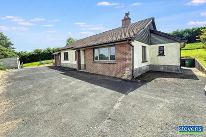
- Price
- Offers in Excess of£450,000
- Size
- 1.3 acres
Petrockstow, Okehampton, Devon, EX20, Petrockstow, Devon EX20 England
Added on 30/05/2026House with Land