Land At Brackenborough Road
Key Features
- Grade 3 Agricultural Land
- 50.41 hectares (124.56 acres)
Description
The land at Brackenborough Road comprises a single, attractive and easily managed block of productive Grade 3 arable land, strategically positioned on the edge of Louth-s industrial estate. Offered as a ring-fenced holding with good access, the property presents an excellent opportunity as a high-quality satellite unit or as a strategic addition to an existing farming operation.
Extending to approximately 50.41 hectares (124.56 acres), the land occupies a strategic edge-of-town position and comprises an attractive single block with strong commercial appeal. The parcels are of a good size and regular shape, making the holding highly suitable for modern farming practices and efficient day-to-day management.
The farm benefits from direct access via the adjoining public highway, with an internal access farm track, together with interconnecting field gateways.
The land is classified as Grade 3 on the Agricultural Land Classification Map, with soils falling within the Holderness Soil Series, as identified on the Soil Survey of England and Wales. These soils are typically described as shallow, permeable calcareous fine loamy soils over limestone, in addition to deeper calcareous and slowly permeable fine loamy soils, with some narrow strips of clayey alluvial soils.
The farm has historically been managed within a cereal-based rotation. A full cropping history is available from the seller-s agents.
The property is offered for sale by private treaty as a whole. The guide price for the whole is £1,200,000
To book an appointment to view this property please phone the Henley-on-Thames Rural branch and quote ID: 103566.
Disclaimer
Simmons & Sons Surveyors LLP for themselves and for the vendors or lessors of the property whose agents they are give notice that: (i) the particulars are produced in good faith, are set out as a general guide only and do not constitute any part of a contract or offer; (ii) all descriptions, dimensions, references to condition and necessary permissions for use and occupation, and any other details are given in good faith and are believed to be correct, but any intending purchasers or tenants should not rely on them as statements or representations of fact but must satisfy themselves by inspection or otherwise as to the correctness of each of them; (iii) No person in the employment of Simmons & Sons has any authority to make or give any representation or warranty whatsoever in relation to this property.
Map Location
Property details
- Tenure
- Ask Agent
- Council Tax Band
- Ask Agent
- Date Posted
- 2026-06-05
Utilities & Restrictions
Utilities
- Electricity
- Ask Agent
- Water
- Ask Agent
- Heating
- Ask Agent
- Broadband
- Ask Agent
- Sewerage
- Ask Agent
Rights & Restrictions
- Public Rights of Way
- Ask Agent
- Private Rights of Way
- Ask Agent
- Listed Property
- Ask Agent
- Restrictions
- Ask Agent
Property Features
- Accessibility
- Ask Agent
- Parking
- Ask Agent
- Garden
- Ask Agent
Important notice: Information, maps and tags on this page are supplied by the advertising agent or generated automatically. LandSale has not verified them. Relying on these details is at your own risk, always carry out independent checks before committing to a purchase.
LandSale full disclaimer
Marketing information only - not formal particulars. The details on this website are provided for general guidance and do not constitute an offer or contract. Neither LandSale nor the advertising estate/land agent accepts responsibility for any inaccuracy.
1. Source of information
- Agent-supplied content: Core description, asking price, tenure, measurements, photographs and planning history are uploaded by the appointed agent, who remains solely responsible for their accuracy.
- Automated tags & categorisation: Property type, land-use class, acreage bands and similar labels may be applied by machine-learning models. They are intended as a helpful guide only and may not reflect the property's legal status or permitted use.
- Third-party & enriched data layers: Maps, boundary outlines, planning designations, soil reports, broadband coverage and other environmental or location-based insights are licensed from external suppliers. Such data are supplied “as is", may be incomplete or out of date and are subject to change without notice.
2. Verification required
Prospective purchasers must verify critical matters, including but not limited to planning permission, title boundaries, public rights of way, environmental constraints, acreage, services, access and VAT status, through their own inspections, specialist surveys, legal advisers and the selling agent before relying on the information or entering into any contract.
3. No warranty or liability
LandSale gives no warranty, express or implied, as to the accuracy, completeness or fitness for any particular purpose of the information displayed. LandSale shall not be liable for any loss, damage, cost or expense arising directly or indirectly from any use of or reliance on such information, save where liability may not be excluded by law.
4. Updates & feedback
If you believe any detail on this listing is inaccurate, please let us know. We will investigate and, where appropriate, update the listing or notify the agent.
© LandSale | Version 1.2 - January 2026
Listing agent
Simmons & Sons, Henley-on-Thames
32 Bell Street, Henley-On-Thames, RG9 2BH
Similar properties for sale

- Price
- Guide Price£1,200,000
- Size
- 124.56 acres
Land At Brackenborough, Louth, Lincolnshire, LN11 0NR, Keddington, Lincolnshire LN11 0NR England
Added on 18/06/2026Arable Land
- Price
- Guide Price£1,200,000
- Size
- 120.12 acres
Waltham, North East Lincolnshire, DN37, Waltham, North East Lincolnshire DN37 0EQ England
Added on 07/06/2026Farmland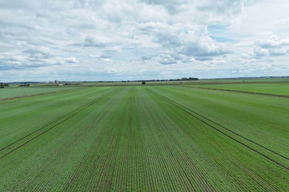
- Price
- Guide Price£930,000
- Size
- 124.44 acres
Added on 13/06/2026Farmland
- Price
- Guide Price£950,000
Wyberton, Boston (Lincolnshire), Wyberton, Lincolnshire PE21 7LE England
Added on 29/01/2026Development Land