Weston Road, Loxton, Axbridge, Somerset, BS26
- Land size
- 10.04 acres
- Bedrooms
- 5
- Bathrooms
- 2
Key Features
- Imposing detached house in an elevated position with unspoilt countryside views
- Five bedrooms
- Set in circa 9 acres of pasture land and woodland
- Range of useful outbuildings
- Stable block of three
- Triple garage with the potential to convert (STPP)
Description
An imposing five bedroom detached home, located in a elevated yet private position with panoramic views over surrounding countryside and The Mendip Hills beyond. The property is situated in circa 10.04 acres of gently slopping pasture land and abundant woodland combined. A range of useful outbuilding including three stables create excellent smallholding and equestrian opportunities, whilst the property has been brought to the market with the benefit of no onward chain.
In brief, the ground floor accommodation comprises spacious entrance hall, lounge, dining room, kitchen/breakfast room, utility and cloakroom. The property is overflowing with natural light with the lounge being of particular prominence. Patio doors overlooking countryside to the south and further aspect towards The Mendip Hills in the East, provide an impressive outlook, whilst an inglenook fireplace with wood burner inset creates a rustic atheistic. The dining room creates an excellent formal entertaining space, complete with alcove storage and natural stone fireplace. The kitchen/breakfast room has been well stocked with a good level of wall, draw and base units, ample space for freestanding white goods as well as additional room for more informal dinning. Patio doors lead out from here onto an elevated garden, creating the perfect 'day-to-day' family space. Adjoining the kitchen is an exceptionally useful utility room, with additional kitchen cabinetry, 'Belfast' sink and plumbing points for both a washing machine and tumble dryer.
On the first floor are five bedrooms, a family bathroom and en-suite facilities. Bedrooms one and two are impressively spacious double rooms, boasting unspoilt and far reaching views over the surrounding land and countryside beyond. Bedrooms three, four and five are more comfortable double rooms in size, with views to the side and rear respectively. The contemporary family bathroom consists bath, walk in double shower unit, WC and wash hand basin. Complimentary tiling has been applied to all splash prone areas. The en-suite has been fitted to include a corner shower unit, WC, and vanity unit with sink inset.
From Weston Road a single track driveway meanders up to Westhill House, whilst providing access to the agricultural outbuildings, stabling and detached triple garage. From the driveway and with access off of, 4.60 acres of gently slopping pasture land encloses the Western boundary and has provided excellent equestrian use for the current owners over a number of years. The land is currently separated into four equal lots, delineated by post and rail fencing. Across the driveway is a range of useful outbuildings including a stable block of three with concrete hardstanding, steel mono-pitched building with timber cladding, currently used as hay storage and block built outbuilding providing an excellent refuse area for the necessary machinery to run such an impressive small holding. Mains electric has been connected to all three buildings whilst mains water is available from the stables. From here and heading up the driveway a further post and rail paddock has been used by the current owners as grazing for their flock of Lowland pedigree sheep and adjoining duck run. The remaining greenery to the front of the home has been laid to a meadow grass lawn, and provides the perfect balance for families who are looking to utilise the land, whilst still having accessible space in which children can happily play in. As previously mentioned Westhill House affords a commanding presence on the skyline with its elevated position. Steps lead from the driveway up to the front of the house, where we find a landscaped garden, predominately laid to gravel, with a smattering of established floral boarders. The current owners have found this to be the perfect spot in which to site their hot tub, an idyllically tranquil spot from which to soak in the stunning vista that surrounds you to the South. Ample off road parking is provided with two gravelled bays suitable for a significant amount of cars, leading up to the triple garage. Formerly an old agricultural building the garage can be accessed via traditional double barn doors and single stable door and has been fitted with the benefit of both light and power. Additional storage space is available on the first floor of the garage, but also as a collective offers fantastic scope for conversion (subject to gaining the relevant consents) to either provide ancillary accommodation to the main house for a dependant relative, a home gym or further use to suit the needs of a prospective purchaser. The gravelled track continues beyond the house to the North and up into the woodland area which measures circa 3.73 acres. The woodland predominately is densely populated with mature trees and foliage, however our current vendors have cleverly created a collection of secluded openings that have provided fantastic outside seating areas for both parents and children alike to enjoy. One clearing of particular note currently houses a wooden yurt with panoramic views of Crooks Peak and The Mendip Hills beyond.
In total Westhill House sits in circa 10.04 acres of versatile and tranquil land, the presents an exciting opportunity for those looking for either equestrian uses or small holding.
'What we love'
The property offers incredible versatility with stunning panoramic views, peaceful private woodland and expansive grounds. Loxton village is a really vibrant, active and welcoming community.
Map Location
Property details
- Tenure
- Freehold
- Council Tax Band
- F
- Date Posted
- 2026-06-24
Market Value Analysis
Compared with 207 Homes with Land listings in South West England (10+ acres).
Energy Performance Certificate
Energy Efficiency Rating
Based on UK Energy Performance Certificate standards (EU Directive 2002/91/EC)
Running costs are one side. Planning activity, flood history and ground risks for this location are in the full report.
Utilities & Restrictions
Utilities
- Electricity
- Mains
- Water
- Mains
- Heating
- Oil Heating
- Broadband
- Ask Agent
- Sewerage
- Septic Tank / Private
Rights & Restrictions
- Public Rights of Way
- Ask Agent
- Private Rights of Way
- Ask Agent
- Listed Property
- Ask Agent
- Restrictions
- Ask Agent
Listed status, conservation areas and planning constraints for this location are in the full report.
Property Features
- Accessibility
- Ask Agent
- Parking
- Parking Available
- Garden
- Garden
Beyond the particulars: planning activity, flood history, heritage and ground risks, checked for this exact spot.
Connectivity
Broadband
Fastest speed available at this postcode
1 Gbps
Gigabit full fibre
Suitable for
- 4K streaming on every screen
- Full-time home working
- Online gaming & big downloads
Mobile signal
Predicted 4G and 5G signal; indoor signal depends on building materials.
Ofcom Connected Nations postcode-level predictions. Speeds and signal are modelled, not measured, and vary between addresses and providers.
Signal is the easy part. Planning activity, flood history and protected designations here are in the full report.
Nearest Schools
Primary
- Hutton Church of England Primary School2.3 milesNo Ofsted rating
- Ages
- 4 to 11
- Pupils
- 200
- Type
- Academy converter
- Faith
- Church of England
- Lympsham Church of England Academy2.3 milesNo Ofsted rating
- Ages
- 2 to 9
- Pupils
- 139
- Type
- Academy converter
- Faith
- Church of England
- Locking Primary School2.7 milesOfsted report card · Jun 2026
- Ages
- 2 to 11
- Pupils
- 386
- Type
- Academy converter
- East Brent Church of England First School2.8 milesNo Ofsted rating
- Ages
- 2 to 9
- Pupils
- 77
- Type
- Academy converter
- Faith
- Church of England
- Banwell Primary School2.8 milesOfsted report card · Mar 2026
- Ages
- 4 to 11
- Pupils
- 137
- Type
- Academy converter
Secondary
- Winterstoke Hundred Academy3.4 milesOfsted: Good
- Ages
- 11 to 19
- Pupils
- 870
- Type
- Free schools
- Broadoak Academy3.9 milesOfsted: Good
- Ages
- 11 to 16
- Pupils
- 792
- Type
- Academy converter
- Hans Price Academy3.9 milesNo Ofsted rating
- Ages
- 11 to 16
- Pupils
- 1,046
- Type
- Academy sponsor led
- Worle Community School4.2 milesOfsted report card · Jun 2026
- Ages
- 11 to 16
- Pupils
- 1,244
- Type
- Academy sponsor led
- Priory Community School4.8 milesOfsted: Good
- Ages
- 11 to 16
- Pupils
- 1,486
- Type
- Academy converter
Distances are straight-line from the advertised location. Source: the national school registers (DfE, Welsh Government, Scottish Government) and Ofsted.
Schools are just the start: sold prices nearby, planning activity and any flood history are in the full report.
Amenities
Supermarket
GP surgery
Pharmacy
Hospital
Straight-line distances from the advertised location. Sources: NHS records, Geolytix supermarket locations, OS Open Greenspace and the national trails registers.
The area stacks up? Now check the location itself: planning nearby, protected designations and past flooding.
Getting Around
Nearest station
Nearest bus stop
Typical drive times
Straight-line distances from the advertised location; drive times are typical free-flow times over OpenStreetMap road data, so allow more at peak. Public transport locations from DfT NaPTAN.
Easy to reach matters. So do planning activity, flood history and ground risks: all in the full report.
Flood Risk
Environment Agency open data, checked around the advertised map pin for the listed acreage. Long-term risk counts flood defences; the planning map's flood zones do not. The map pin for this listing is approximate, so these readings describe the surrounding area. Provided by LandSale, not the listing agent, and not part of the agent's particulars. Risk varies across a holding, so verify before committing.
Rivers and the sea
Not at the pin: mapped about 90 metres away.
Planning map: Flood Zone 3.
Surface water
These bandings are the summary. Where this location sits on the flood maps, plus planning activity, heritage and ground risks, is in the full report.
Important notice: Information, maps and tags on this page are drawn from the advertising agent's marketing materials or generated automatically. LandSale has not verified them. Relying on these details is at your own risk, always carry out independent checks before committing to a purchase.
LandSale full disclaimer
Marketing information only - not formal particulars. The details on this website are provided for general guidance and do not constitute an offer or contract. Neither LandSale nor the advertising estate/land agent accepts responsibility for any inaccuracy.
1. Source of information
- Listing content: Core description, asking price, tenure, measurements, photographs and planning history originate from the marketing materials of the advertising estate or land agent. LandSale does not author this content and cannot guarantee its accuracy.
- Automated tags & categorisation: Property type, land-use class, acreage bands and similar labels may be applied by machine-learning models. They are intended as a helpful guide only and may not reflect the property's legal status or permitted use.
- Third-party & enriched data layers: Maps, boundary outlines, planning designations, soil reports, broadband coverage and other environmental or location-based insights are licensed from external suppliers. Such data are supplied “as is", may be incomplete or out of date and are subject to change without notice.
2. Verification required
Prospective purchasers must verify critical matters, including but not limited to planning permission, title boundaries, public rights of way, environmental constraints, acreage, services, access and VAT status, through their own inspections, specialist surveys, legal advisers and the selling agent before relying on the information or entering into any contract.
3. No warranty or liability
LandSale gives no warranty, express or implied, as to the accuracy, completeness or fitness for any particular purpose of the information displayed. LandSale shall not be liable for any loss, damage, cost or expense arising directly or indirectly from any use of or reliance on such information, save where liability may not be excluded by law.
4. Updates & feedback
If you believe any detail on this listing is inaccurate, please let us know. We will investigate and, where appropriate, update the listing or notify the agent.
© LandSale | Version 1.3 - August 2026

Listing agent
Greenslade Taylor Hunt, Redhill
Unit 6, 8, 9 The Pound, Redhill, BS40 5TZ
Similar properties for sale
- Price
- Offers Over£1,000,000
- Size
- 6 acres
Added on 29/01/2026House with Land
- Price
- Guide Price£795,000
- Size
- 6.43 acres
Badgworth Lane, Badgworth, Axbridge, Somerset, BS26, Badgworth, Somerset BS26 England
Added on 21/03/2026House with Land
- Price
- Guide Price£1,100,000
- Size
- 5.5 acres
Added on 26/06/2026House with Land
- Price
- Guide Price£1,100,000
- Size
- 5 acres
Cheddar Road, Cocklake, Wedmore, BS28, Wedmore, Somerset BS28 England
Added on 29/01/2026Farmhouse
- Price
- £995,000
- Size
- 13 acres
Added on 17/06/2026Farmhouse
- Price
- Guide Price£1,195,000
- Size
- 7.7 acres
Hewish, Weston-super-Mare, North Somerset, BS24, Puxton, North Somerset BS24 England
Added on 20/05/2026House with Land
- Price
- £850,000
- Size
- 7 acres
Merry Lane, East Huntspill, Highbridge, Somerset, TA9, East Huntspill, Somerset TA9 England
Added on 21/07/2026House with Land
- Price
- Guide Price£795,000
- Size
- 5 acres
Added on 28/05/2026House with Land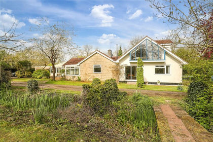
- Price
- Guide Price£1,100,000
- Size
- 10.24 acres
Ham Lane, Kingston Seymour, Clevedon, Somerset, BS21, Kingston Seymour, North Somerset BS21 England
Added on 10/05/2026Equestrian property
- Price
- £975,000
- Size
- 14 acres
Withy Road, West Huntspill, TA9, West Huntspill, Somerset TA9 England
Added on 29/01/2026House with Land