Cross Of The Tree Farm, Lingen, Bucknell, Shropshire, SY7
- Land size
- 15.44 acres
- Bedrooms
- 3
- Bathrooms
- 2
Key Features
- Located In A truly Idyllic Rural Location, Close to The Village Of Lingen On The North Herefordshire/South Shropshire/Welsh Borders
- Smallholding/Equestrian Property Extending To Approximately 15.44 ACRES
- Charming, Well Presented Detached 3 Double Bedroomed Farmhouse
- Range Of Brick Built Outbuildings Incorporating A 1 Bed Studio Flat, Stabling & Tack Room
- A Further Range Of Useful Outbuildings/Barns Including A newly Built Steel Portal Framed Barn
- Extensive Pasture/Paddock Land, Enclosed Yard Area & Ample Courtyard Parking
- Pleasant Form Gardens & Large Patio Seating Area.
Description
Smallholding/Equestrian Property | Nestled In Idyllic Rural Countryside | Gardens & Grounds Extending To Approx. 15.44 ACRES | Farmhouse Offering Flexible 3 Double Bedroomed Accommodation | Large Kitchen/Dining Room | 3 Reception Rooms | 1 En-Suite & Family Bathroom | Extensive Outbuilding Including Stabling/Barns & Large Steel Portal Framed Barn | Brick Outbuilding Incorporating 1 Bed Studio Annex | Excellent Paddock/Pasture Land | Viewing Recommended
Cross of the Tree Farm is set in the magnificent rolling countryside, nestled on the South Shropshire/North Herefordshire/Welsh borders. There are several well-regarded villages and towns within easy access of the property. Lingen is a charming village with a strong community, a parish church and a brilliant local pub, The George. Wigmore village has a community shop, pub/restaurant and provides excellent schooling for all ages. Nearby Leintwardine boasts an excellent village shop and petrol station, butcher, pop-up bakery, primary school, pubs and restaurants and a well-regarded fish and chip shop!
The nearby market town of Presteigne is brilliantly quirky and eclectic, with a vibrant community, full of character, offering some excellent independent shops such as butchers and greengrocers, cafés, restaurants and popular delicatessens.
The historic market town of Ludlow to the east continues to enjoy immense popularity from both locals and visitors alike. Ludlow and Leominster both have train stations on the main Manchester to Cardiff railway line. The A49 links Shrewsbury to the north and Hereford to the south, with the main motorway network accessed towards Kidderminster via the A4117.
This impressive smallholding is nestled in a tranquil and truly idyllic rural location, surrounded by beautiful rolling countryside. Believed to date back to the 17th century, the house itself offers the character and charm of a period property, with the comforts of a modern home. From the courtyard an impressive timber framed porch frames the front door which leads through to a large entrance hall/boot room with cloakroom w/c off. The excellent farmhouse style kitchen/dining/sitting room forms the heart of the home, featuring parquet flooring, exposed ceiling timbers, range of country style units, electric 3 oven dual control Aga with views over the gardens to the rear. The drawing room provides a lovely spacious family room, featuring an impressive inglenook fireplace with an inset wood-burning stove. There is also a large study leading off the drawing room which has been used by the current owners as a fourth bedroom and a charming snug/garden room with a door leading out to the rear patio and gardens. The first floor accommodation offers three double bedrooms with the benefit of one en-suite and a superb family bathroom.
OUTSIDE Set in 15.44 acres of gardens and grounds, Cross Of The Tree Farm is nestled in a truly idyllic and tranquil rural location. A gated driveway leads to an attractive courtyard which is framed by a traditional brick-built outbuilding which includes a range of stables, tack room and also incorporates a self-contained, first floor studio flat with kitchen, bathroom and bedroom but currently utilised as a study/office space. Below the flat the former double carport has been enclosed to create a gym. To the rear of the house there is a lovely gravelled and patio seating area before leading onto the attractive formal gardens.
To the rear of the brick stables are a further, extensive range of outbuildings including large barns, additional stabling and further storage and open out to a further yard area with separate access onto the country lane.
The extensive pasture/meadow land is divided into several individual paddocks and is quite evenly split spanning both sides of the quiet country lane. The large paddock on the opposite side of the lane also includes a substantial, newly build steel portal framed barn with yard area. Adding further appeal, the current owners have secured the relevant permissions to create a small campsite, presenting an exciting opportunity to generate additional income. Further information is available upon request.
Services, Expenditure & Important Material Information
Tenure: FREEHOLD
Services Connected: Mains Electricity, private water via a bore hole, private drainage to a septic tank.
Council Tax Band: E
Flood Risk: Very Low
Build Date:
Broadband availability: Ultrafast 1000Mbps
Phone Coverage: 4g Available and can be found at
Wayleaves, rights of way and easements: The property will be sold subject to and with the benefit of all wayleaves, easements and rights of way, whether mentioned in these particulars or not.
Compliance Fees & Information
Jackson Property may be entitled to commission from other services offered to the client or a buyer including but not limited to: Conveyancing, Mortgage, Financial advice and surveys. Information on the group structure and referral fees can be found on our website.
Any purchasers that have a succesful agreed offer will be subject to an online Anti Money Laundering compliance check. This can be with one of our providers Kotini with APPLYID. The cost for this is £25.20 Including vat per accepted offer. Example, Mr & Mrs Jones have an agreed offer via ourselves, before any memorandum of sale is sent out, a request of information and payment to our partners of £25.20 including vat (£21 + vat) needs to be paid and a satisfactory AML check and Proof of Funding check.
Digital Markets, Competition and Consumers Act 2024 (Commencement No.2) Regulations 2025
We endeavour to ensure that the details contained in our marketing are correct through making detailed enquiries of the owner(s), however they are not guaranteed.
Jackson Property Group have not tested any appliance, equipment, fixture, fitting or service. Any intending purchasers must satisfy themselves by inspection or otherwise as to the correctness of each statement contained within these particulars.
Any research and literature advertised will have been done at the time of initial marketing by ourselves or partners, on behalf of the owners and ourselves, with the owners signing off their own information.
Services & Expenditures advertised have been taken from | |
Map Location
Property details
- Tenure
- Freehold
- Council Tax Band
- E
- Date Posted
- 2026-07-01
Market Value Analysis
Compared with 118 Homes with Land listings in West Midlands (10+ acres).
Energy Performance Certificate
Energy Efficiency Rating
Based on UK Energy Performance Certificate standards (EU Directive 2002/91/EC)
Running costs are one side. Planning activity, flood history and ground risks for this location are in the full report.
Utilities & Restrictions
Utilities
- Electricity
- Mains
- Water
- Ask Agent
- Heating
- Double Glazing, Wood Burner
- Broadband
- Full Fibre (FTTP)
- Sewerage
- Septic Tank / Private
Rights & Restrictions
- Public Rights of Way
- Ask Agent
- Private Rights of Way
- Ask Agent
- Listed Property
- Ask Agent
- Restrictions
- Ask Agent
Listed status, conservation areas and planning constraints for this location are in the full report.
Property Features
- Accessibility
- Ask Agent
- Parking
- Disabled Parking, Driveway, Gated Parking, Rear Parking, Private Parking, No Permit Required
- Garden
- Garden
Beyond the particulars: planning activity, flood history, heritage and ground risks, checked for this exact spot.
Connectivity
Broadband
Fastest speed available at this postcode
1 Gbps
Gigabit full fibre
Suitable for
- 4K streaming on every screen
- Full-time home working
- Online gaming & big downloads
Fixed wireless access may also be an option here.
Mobile signal
Predicted 4G and 5G signal; indoor signal depends on building materials.
Ofcom Connected Nations postcode-level predictions. Speeds and signal are modelled, not measured, and vary between addresses and providers.
Signal is the easy part. Planning activity, flood history and protected designations here are in the full report.
Nearest Schools
Primary
- Wigmore Primary School2.3 milesNo Ofsted rating
- Ages
- 2 to 11
- Pupils
- 169
- Type
- Academy converter
- Shobdon Primary School3.7 milesOfsted: Good
- Ages
- 5 to 11
- Pupils
- 74
- Type
- Community school
- St Mary's CofE Primary School4.2 milesOfsted: Good *
- Ages
- 2 to 11
- Pupils
- 55
- Type
- Voluntary aided school
- Faith
- Church of England
- Leintwardine Endowed CE Primary School4.5 milesOfsted: Good
- Ages
- 4 to 11
- Pupils
- 75
- Type
- Voluntary aided school
- Faith
- Church of England
- Kingsland CofE School5.6 milesOfsted: Good
- Ages
- 5 to 11
- Pupils
- 155
- Type
- Voluntary aided school
- Faith
- Church of England
Secondary
- Wigmore School2.4 milesNo Ofsted rating
- Ages
- 11 to 19
- Pupils
- 467
- Type
- Academy converter
- Lady Hawkins' School8.8 milesOfsted: Good *
- Ages
- 11 to 16
- Pupils
- 281
- Type
- Academy converter
- Earl Mortimer College9.1 milesOfsted: Good
- Ages
- 11 to 16
- Pupils
- 502
- Type
- Community school
- Ludlow Church of England School9.3 milesOfsted: Requires improvement *
- Ages
- 11 to 16
- Pupils
- 626
- Type
- Academy converter
- Faith
- Church of England
- Weobley High School10 milesNo Ofsted rating
- Ages
- 11 to 16
- Pupils
- 533
- Type
- Community school
* Latest graded judgement covers quality of education only; no overall grade was issued under the 2024-25 inspection framework.
Distances are straight-line from the advertised location. Source: the national school registers (DfE, Welsh Government, Scottish Government) and Ofsted.
Schools are just the start: sold prices nearby, planning activity and any flood history are in the full report.
Amenities
Supermarket
GP surgery
Pharmacy
Hospital
Straight-line distances from the advertised location. Sources: NHS records, Geolytix supermarket locations, OS Open Greenspace and the national trails registers.
The area stacks up? Now check the location itself: planning nearby, protected designations and past flooding.
Getting Around
Nearest station
Nearest bus stop
Typical drive times
Straight-line distances from the advertised location; drive times are typical free-flow times over OpenStreetMap road data, so allow more at peak. Public transport locations from DfT NaPTAN.
Easy to reach matters. So do planning activity, flood history and ground risks: all in the full report.
Flood Risk
Environment Agency open data, checked around the advertised map pin for the listed acreage. Long-term risk counts flood defences; the planning map's flood zones do not. Provided by LandSale, not the listing agent, and not part of the agent's particulars. Risk varies across a holding, so verify before committing.
Rivers and the sea
Planning map: Flood Zone 1.
Surface water
Not at the pin: mapped about 120 metres away.
These bandings are the summary. Where this location sits on the flood maps, plus planning activity, heritage and ground risks, is in the full report.
Important notice: Information, maps and tags on this page are drawn from the advertising agent's marketing materials or generated automatically. LandSale has not verified them. Relying on these details is at your own risk, always carry out independent checks before committing to a purchase.
LandSale full disclaimer
Marketing information only - not formal particulars. The details on this website are provided for general guidance and do not constitute an offer or contract. Neither LandSale nor the advertising estate/land agent accepts responsibility for any inaccuracy.
1. Source of information
- Listing content: Core description, asking price, tenure, measurements, photographs and planning history originate from the marketing materials of the advertising estate or land agent. LandSale does not author this content and cannot guarantee its accuracy.
- Automated tags & categorisation: Property type, land-use class, acreage bands and similar labels may be applied by machine-learning models. They are intended as a helpful guide only and may not reflect the property's legal status or permitted use.
- Third-party & enriched data layers: Maps, boundary outlines, planning designations, soil reports, broadband coverage and other environmental or location-based insights are licensed from external suppliers. Such data are supplied “as is", may be incomplete or out of date and are subject to change without notice.
2. Verification required
Prospective purchasers must verify critical matters, including but not limited to planning permission, title boundaries, public rights of way, environmental constraints, acreage, services, access and VAT status, through their own inspections, specialist surveys, legal advisers and the selling agent before relying on the information or entering into any contract.
3. No warranty or liability
LandSale gives no warranty, express or implied, as to the accuracy, completeness or fitness for any particular purpose of the information displayed. LandSale shall not be liable for any loss, damage, cost or expense arising directly or indirectly from any use of or reliance on such information, save where liability may not be excluded by law.
4. Updates & feedback
If you believe any detail on this listing is inaccurate, please let us know. We will investigate and, where appropriate, update the listing or notify the agent.
© LandSale | Version 1.3 - August 2026
Similar properties for sale
- Price
- Guide Price£1,350,000
- Size
- 12.52 acres
Titley, Kington, Herefordshire, County, HR5, Staunton on Arrow, Herefordshire, County of HR5 England
Added on 29/01/2026Country Estate
- Price
- Guide Price£875,000
- Size
- 18 acres
Wallstych Lane, Floodgates, Kington, Kington Rural, Herefordshire, County of HR5 England
Added on 29/01/2026House with Land
- Price
- Offers in Region of£895,000
- Size
- 9.7 acres
Treburvaugh House, Knighton, LD7, Llangunllo, Powys LD7 Wales
Added on 28/08/2026Country Home
- Price
- Offers Over£1,100,000
- Size
- 12 acres
Added on 30/04/2026House with Land
- Price
- Guide Price£1,300,000
- Size
- 20 acres
Added on 05/03/2026Country Home
- Price
- Guide Price£1,000,000
- Size
- 19.5 acres
Stirbridge Farm, Risbury, Leominster, Herefordshire, Humber, Herefordshire, County of HR6 England
Added on 15/05/2026Smallholding
- Price
- Guide Price£1,100,000
- Size
- 7 acres
Dolau, Llandrindod Wells, Powys, LD1, Llanfihangel Rhydithon, Powys LD1 Wales
Added on 29/01/2026Country Home
- Price
- Guide Price£1,125,000
- Size
- 9 acres
Winforton, Hereford, Willersley and Winforton, Herefordshire, County of HR3 England
Added on 29/01/2026Country Home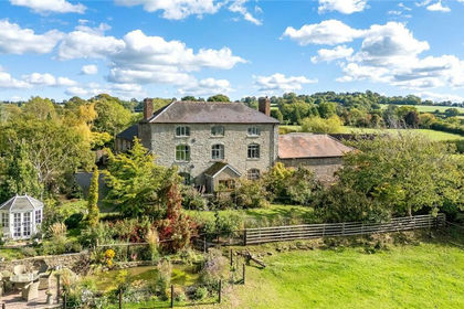
- Price
- Guide Price£1,100,000
- Size
- 10 acres
Cold Weston, Craven Arms, Shropshire, SY7, Clee St. Margaret, Shropshire SY7 England
Added on 08/08/2026Farmhouse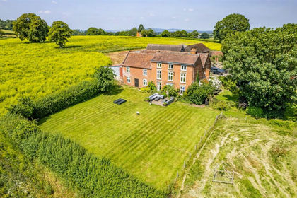
- Price
- Guide Price£1,200,000
- Size
- 18.88 acres
Added on 28/06/2026Agricultural Land