2 Maesgwm, Ganllwyd, Dolgellau, LL40
- Land size
- 15.02 acres
- Bedrooms
- 3
- Bathrooms
- 1
Key Features
- Semi Detached House
- In need of full refurbishment
- Approx. 15 acres of rough grazing land
- Sitting Room
- Kitchen/Dining Room
- 3 Bedrooms
- Bathroom
- Stable and Tack Room (in need of total refurbishment)
- Current EPC Rating G
Description
2 Maesgwm is a traditional three-bedroom semi-detached property set within approximately 15.02 acres of predominantly rough grazing, offering an excellent opportunity for purchasers seeking a rural lifestyle, space for livestock, or simply the benefit of extensive surrounding land.
The property requires comprehensive refurbishment and modernisation. Much of the interior has already been stripped back, with some renovation works commenced, providing an ideal blank canvas for a new owner to complete the project to their own specification. Works are likely to include reconfiguring the internal layout, installing a central heating system, and carrying out further improvements to create a comfortable modern home.
Despite its current condition, the property retains a wealth of character features, including an impressive inglenook fireplace with its original bread oven and attractive exposed beamed ceilings.
The property benefits from a private hillside water supply, while drainage is provided via a shared septic tank serving the adjoining property.
A particular feature of the property is the adjoining land, extending to approximately 15.02 acres. The land is accessed directly from the house and also benefits from a vehicular and pedestrian right of way over the adjoining access track, providing convenient access throughout the holding. Part of the land is bordered by a river.
The property is expected to appeal to purchasers seeking a refurbishment project with significant potential, allowing them to create a home tailored to their own tastes. Its combination of substantial land, traditional character, and semi-rural setting, while still benefiting from a small community of neighbouring properties, makes it an increasingly rare opportunity.
The accommodation briefly comprises: entrance into the kitchen, hallway, potential shower room, sitting room, first-floor landing, three bedrooms, and a family bathroom.
Externally, the property benefits from a stable, a store shed, and a dilapidated former cowshed at the top of the land, which offers further potential for rebuilding or alternative uses, subject to obtaining the necessary planning permissions and statutory consents.
What3Words - ///lunge.brownish.unlocking
Location
Located within the Coed Y Brenin Forestry, the property provides easy access to the surrounding woodland, with mountain biking and walks on the doorstep.
The ancient market town of Dolgellau sits within an area of outstanding natural beauty set in the Southern Snowdonia National Park, at the foot of the Cader Idris mountain range. Dolgellau is an excellent base for walkers and outdoor pursuits. The town provides a small cottage hospital, primary & secondary schools, a tertiary college as well as restaurants, pubs, library, rugby & cricket clubs and is within 10 miles of the coast and 6 miles of a main line railway station.
Council Tax Band: D - £2,433.26
Tenure: Freehold
The septic tank is shared with the neighbouring property and it is located on their land.
The water supply is shared, serving a cluster of properties in the locality.
Please refer to the boundary plan attached to the sales particulars to see where the boundary lies.
Porch
Opening to front, window to side, concrete floor, door and step up to:
Kitchen/Dining Room
Two windows to front, exposed beams, concrete floor.
Steps down into:-
Hallway
Door to rear, exposed beams, understairs storage, concrete floor.
Shower Room
Window to front, concrete floor.
Sitting Room
Window to front, and rear, exposed beams, large inglenook fireplace with original bread oven, exposed stone walls, concrete floor.
Landing
'U' shaped landing, window to front, part pitch pine panelled walls, exposed floorboards.
Bedroom 1
Window to front, access to loft, cast iron fireplace, exposed floorboards.
Bathroom
Window to front, cast iron panel bath, low level W.C., wash hand basin, exposed floorboards.
Bedroom 2
Window to rear, exposed stone walls, exposed floorboards.
Bedroom 3
Window to rear, pitch pine panelled walls, exposed floorboards.
Outside
The property is approached via a private access track, shared with the adjoining property, leading to an off-road parking area. Entry to the house is available via both the front and rear entrance doors.
To the front of the property is a lawned garden, with steps leading down to the stable. Beyond a traditional stone boundary wall and gated entrance lies the adjoining land, extending to approximately 15 acres, forming an attractive and integral part of the holding.
The property further benefits from a vehicular and pedestrian right of way over the access track running alongside the southern boundary, providing convenient access to the land.
A boundary plan is included with these particulars for identification purposes and to illustrate the extent of the land.
Stable
Stone built, slated roof, in need of refurbishment.
Map Location
Property details
- Tenure
- Freehold
- Council Tax Band
- D
- Date Posted
- 2026-08-04
Market Value Analysis
Compared with 174 Homes with Land listings in Wales (10+ acres).
Energy Performance Certificate
Energy Efficiency Rating
Based on UK Energy Performance Certificate standards (EU Directive 2002/91/EC)
View official EPC certificate ↗
Running costs are one side. Planning activity, flood history and ground risks for this location are in the full report.
Utilities & Restrictions
Utilities
- Electricity
- Mains
- Water
- Private Supply
- Heating
- Ask Agent
- Broadband
- No Internet Connection
- Sewerage
- Septic Tank / Private
Rights & Restrictions
- Public Rights of Way
- Ask Agent
- Private Rights of Way
- Ask Agent
- Listed Property
- Ask Agent
- Restrictions
- Ask Agent
Listed status, conservation areas and planning constraints for this location are in the full report.
Property Features
- Accessibility
- Ask Agent
- Parking
- Driveway
- Garden
- Enclosed Garden
Beyond the particulars: planning activity, flood history, heritage and ground risks, checked for this exact spot.
Connectivity
Broadband
Fastest speed available at this postcode
7 Mbps
Under 10 Mbps here
Suitable for
- Basic browsing & email
Mobile signal
Predicted 4G and 5G signal; indoor signal depends on building materials.
Ofcom Connected Nations postcode-level predictions. Speeds and signal are modelled, not measured, and vary between addresses and providers.
Signal is the easy part. Planning activity, flood history and protected designations here are in the full report.
Nearest Schools
Primary
- Ysgol Bro Hedd Wyn4.7 miles
- Pupils
- 64
- Type
- Nursery, Infants & Juniors
- Language
- Welsh medium school / provision (including transitional)
- Bro Idris6.5 miles
- Pupils
- 541
- Type
- Middle (ages 3-16)
- Language
- Welsh medium school / provision (including transitional)
- Ysgol Edmwnd Prys7.6 miles
- Pupils
- 18
- Type
- Nursery, Infants & Juniors
- Language
- Welsh medium school / provision (including transitional)
- Ysgol Gynradd Llanbedr7.6 miles
- Pupils
- 43
- Type
- Infants & Juniors
- Language
- Welsh medium school / provision (including transitional)
- Ysgol Talsarnau7.9 miles
- Pupils
- 26
- Type
- Nursery, Infants & Juniors
- Language
- Welsh medium school / provision (including transitional)
Secondary
- Bro Idris6.5 miles
- Pupils
- 541
- Type
- Middle (ages 3-16)
- Language
- Welsh medium school / provision (including transitional)
- Ysgol Ardudwy8.4 miles
- Pupils
- 331
- Type
- Secondary (ages 11-16)
- Language
- Welsh medium school / provision (including transitional)
- Ysgol Y Moelwyn11 miles
- Pupils
- 355
- Type
- Secondary (ages 11-16)
- Language
- Welsh medium school / provision (including transitional)
- Ysgol Eifionydd11 miles
- Pupils
- 373
- Type
- Secondary (ages 11-16)
- Language
- Welsh medium school / provision (including transitional)
- YSGOL Godre'r Berwyn14 miles
- Pupils
- 571
- Type
- Middle (ages 3-19)
- Language
- Welsh medium school / provision (including transitional)
Distances are straight-line from the advertised location. Source: the national school registers (DfE, Welsh Government, Scottish Government) and Ofsted.
Schools are just the start: sold prices nearby, planning activity and any flood history are in the full report.
Amenities
Supermarket
GP surgery
Pharmacy
Straight-line distances from the advertised location. Sources: NHS records, Geolytix supermarket locations, OS Open Greenspace and the national trails registers.
The area stacks up? Now check the location itself: planning nearby, protected designations and past flooding.
Getting Around
Nearest station
Nearest bus stop
Typical drive times
Straight-line distances from the advertised location; drive times are typical free-flow times over OpenStreetMap road data, so allow more at peak. Public transport locations from DfT NaPTAN.
Easy to reach matters. So do planning activity, flood history and ground risks: all in the full report.
Flood Risk
Natural Resources Wales open data, checked around the advertised map pin for the listed acreage. Long-term risk counts flood defences; the planning map's flood zones do not. Provided by LandSale, not the listing agent, and not part of the agent's particulars. Risk varies across a holding, so verify before committing.
Rivers and the sea
Planning map: Flood Zone 1.
Surface water
Not at the pin: mapped about 30 metres away.
These bandings are the summary. Where this location sits on the flood maps, plus planning activity, heritage and ground risks, is in the full report.
Important notice: Information, maps and tags on this page are drawn from the advertising agent's marketing materials or generated automatically. LandSale has not verified them. Relying on these details is at your own risk, always carry out independent checks before committing to a purchase.
LandSale full disclaimer
Marketing information only - not formal particulars. The details on this website are provided for general guidance and do not constitute an offer or contract. Neither LandSale nor the advertising estate/land agent accepts responsibility for any inaccuracy.
1. Source of information
- Listing content: Core description, asking price, tenure, measurements, photographs and planning history originate from the marketing materials of the advertising estate or land agent. LandSale does not author this content and cannot guarantee its accuracy.
- Automated tags & categorisation: Property type, land-use class, acreage bands and similar labels may be applied by machine-learning models. They are intended as a helpful guide only and may not reflect the property's legal status or permitted use.
- Third-party & enriched data layers: Maps, boundary outlines, planning designations, soil reports, broadband coverage and other environmental or location-based insights are licensed from external suppliers. Such data are supplied “as is", may be incomplete or out of date and are subject to change without notice.
2. Verification required
Prospective purchasers must verify critical matters, including but not limited to planning permission, title boundaries, public rights of way, environmental constraints, acreage, services, access and VAT status, through their own inspections, specialist surveys, legal advisers and the selling agent before relying on the information or entering into any contract.
3. No warranty or liability
LandSale gives no warranty, express or implied, as to the accuracy, completeness or fitness for any particular purpose of the information displayed. LandSale shall not be liable for any loss, damage, cost or expense arising directly or indirectly from any use of or reliance on such information, save where liability may not be excluded by law.
4. Updates & feedback
If you believe any detail on this listing is inaccurate, please let us know. We will investigate and, where appropriate, update the listing or notify the agent.
© LandSale | Version 1.3 - August 2026
Listing agent
Walter Lloyd Jones & Co., Dolgellau
Bridge Street, Dolgellau, LL40 1AS
Similar properties for sale
- Price
- Guide Price£300,000
- Size
- 15 acres
Added on 13/05/2026Cottage
- Price
- Offers in Region of£335,000
- Size
- 23 acres
Pantperthog, Machynlleth, Gwynedd, SY20, Glantwymyn, Powys SY20 Wales
Added on 04/09/2026House with Land
- Price
- Guide Price£450,000
- Size
- 36.14 acres
Gelli (Lot 3), Llanfair Caereinion, Welshpool, Powys, SY21, Llanfair Caereinion, Powys SY21 Wales
Added on 29/07/2026Farm
- Price
- Guide Price£300,000
- Size
- 24.45 acres
Gelli (Lot 2), Llanfair Caereinion, Welshpool, Powys, SY21, Llanfair Caereinion, Powys SY21 Wales
Added on 29/07/2026Farmland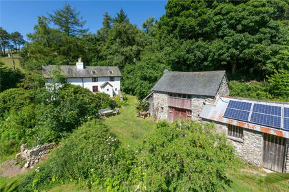
- Price
- £400,000
- Size
- 8.34 acres
Added on 18/06/2026House with Land
- Price
- £295,000
- Size
- 12 acres
Added on 22/06/2026Agricultural Land
- Price
- Guide Price£360,000
- Size
- 20.48 acres
Added on 06/06/2026Smallholding