High House Farm, Gawthrop, Sedbergh, Cumbria
- Land size
- 29.45 acres
- Bedrooms
- 3
- Bathrooms
- 1
Key Features
- Traditional upland smallholding extending to approximately 29.45 acres (11.91 hectares) within the heart of the Yorkshire Dales National Park.
- Grade II Listed three-bedroom farmhouse offering an exciting renovation opportunity.
- Range of traditional stone-built farm buildings with potential for conversion or alternative uses, subject to the necessary consents.
- Productive mowing and grazing land, ideal for livestock, hobby farming or a rural lifestyle enterprise.
- Private and idyllic rural setting with far-reaching countryside appeal in one of England's most sought-after National Parks.
Description
To be sold by Public Auction at Sedbergh People’s Hall, Howgill Lane, Sedbergh, LA10 5DQ on Wednesday 16th September 2026 from 2.45pm. An attractive smallholding, situated in a delightful rural setting in the heart of the Yorkshire Dales National Park.
The property comprises a Grade II* listed three-bedroom traditional farmhouse offering huge amounts of potential, together with a range of
traditional stone-built farm buildings offering scope for conversion or alternative uses, subject to the necessary planning consents.
Extending to approximately 29.45 acres (11.91 hectares), with productive agricultural grazing land and presents an exciting opportunity to create a superb country home, lifestyle property and smallholding within one of the country's most sought-after National Park locations.
Guide Range - £385,000 - £425,000
Description
High House Farm presents a rare opportunity to acquire an attractive upland smallholding occupying an idyllic and elevated position within the heart of the Yorkshire Dales National Park, commanding superb views across the picturesque Dentdale Valley. Set in a peaceful and private rural setting, the holding extends to approximately 29.45 acres (11.91 hectares) of meadow and pasture land, offering excellent potential for livestock grazing, environmental management and a variety of rural lifestyle pursuits.
At the centre of the holding stands a Grade II* Listed traditional three-bedroom farmhouse together with an adjoining, sizeable, stone-built agricultural building and further outhouses. Whilst the farmhouse now requires comprehensive renovation and modernisation and is currently uninhabitable, the property presents an exceptional opportunity to create a distinctive country home or smallholding, with the buildings offering further potential for conversion or alternative uses, subject to obtaining the necessary planning and listed building consents. High House Farm is accessed via a right of access over a newly re-surfaced private hardcore track leading from Stone Rigg Outrake Highway through an adjoining third party owned field.
Directions
Travelling from the M6, taking junction 37, head south-east on the A684 towards the Old Scotch Road until you reach Sedbergh. Take a right onto Busk Lane for approximately 0.5 miles. At the T-Junction, turn right on Loftus Hill. Continue along this road onto Moser Hill Brow, then onto Hall Road, taking the first right over Barth Bridge. Continue along this road for 0.3 miles, then take the first right onto Brackensgill Lane down into Gawthrop. Turn left onto Stone Rigg Outtake which is signposted to Barbon and Kirkby Lonsdale. Continue along this road for approximately 0.5 miles, then the entrance to the newly re-surfaced hard-core track is on found on your left.
Location
High House Farm lies in the Yorkshire Dales National Park, about a mile south of Gawthrop, approximately five miles south-east of Sedbergh. Situated in the county of Cumbria, High House Farm benefits from excellent transport links to the Lake District. Accessed via a private hardcore track, the property benefits from a rural position, overlooking the picturesque Yorkshire Dales Countryside.
Grid Reference: SD
What3Words: loosens.stale.warp
Outside
Agricultural Buildings
High House Farm benefits from a small range of traditional outbuildings that have historically been utilised for stock housing and storage with potential for future development and expansion, subject to the relevant permissions from the Local Authorities. All buildings would benefit from repairs and maintenance. Details and approximate internal measurements of buildings are as follows:
1. Hay Barn 14.65m x 6.93m Traditional bank barn, re-slated in the 1980s with ornate cast iron guttering and mews beneath.
2. Byres 14.59m x 5.44m Traditional stone building with slate roof.
3. Loose Housing 3.90m x 4.60m Concrete block building with tin roof.
4. Traditional Building 2.00m x 2.00m Traditional building with stone flagged roof.
5. Cooling House 2.36m x 3.34m Block built building with rough cast finish under asbestos roof.
6. Farm Store / Loose Box 4.78m x 3.96m Concrete and timber framed building with tin roof.
7. Field Barn 8.68m x 6.49m Traditional stone barn under a slate roof, located between field parcels 11 and 12. Used as hay storage and an old byre.
Please note, due to the unstable condition of the agricultural buildings, we request that no one enters the buildings for the Risk of Health and Safety. It is recommended that interested parties view these buildings from the outside only.
Land
High House Farm benefits from circa. 29.45 acres (11.91 hectares) of good quality meadow and pasture land. The land forms a desirable ring-fence around the farmhouse and steading. The land benefits from natural water supplies from the various springs and gill running through the property. Included within the sale is a small area of deciduous woodland extending to 3.27 acres (1.03 hectares).
There is a public footpath down the access track into High House Farm, this runs from Barbondale Road towards Dent.
Services
Services
A private water supply to the farmhouse is sourced from the neighbouring property. A written agreement documenting this can be supplied upon request from the Selling Agents. This agreement confirms an annual payment of £10 must be paid to the neighbour for the benefit of this water supply.
Mains, single-phase electricity supply. These services have not been tested. Private domestic drainage, it is assumed that this septic tank is non-compliant with the General Binding Rules 2020 and the successful buyer will be understood to have accepted this position. There is currently no central heating system at the property, a number of the reception rooms and bedrooms benefit from open fireplaces.
Key Information
The property is Grade II* Listed List Entry No: 1383968. See further information available at:
We understand that broadband and mobile telephone reception are available. For an indication of speeds and supply please see the OFCOM website:
Auction General
General Information and Stipulations
The following Stipulations where applicable shall be deemed as Special Conditions of Sale. In the event of any variance between the Stipulations and the Special Conditions of Sale then the latter will prevail. Purchasers will also be deemed to have had full notice of the Stipulations and the Special Conditions of Sale and the same will not be read out at the time of sale. The Special Conditions of Sale may be inspected at the Auctioneer’s Offices and also the offices of the Seller’s Solicitors FOURTEEN days prior to the sale.
N.B Prospective purchasers are requested to contact the Seller’s Solicitors to discuss legal matters pertinent to the Sale Contract and documentation.
Solicitors
McGarry Solicitors, 54 Main Street, Sedbergh, Cumbria, LA10 5AB
Tel No: .
Tenure Freehold. Vacant possession upon completion. The date fixed for completion is Friday 16th October 2026 or earlier by mutual agreement.
Method of Sale
The property will be offered for sale as described in these particulars of sale. The vendors reserve the right to alter or withdraw the property prior to Auction.
Water Supplies Private water supply, arrangement as detailed above at ‘services’ above.
Local Authority
Westmorland and Furness Council. Tel no: .
Planning Authority
Yorkshire Dales National Park Planning Authority
Mines and Minerals
Included, insofar as we are aware.
Sporting Rights
Included, insofar as we are aware.
Stewardship Schemes
There are no known Stewardship Schemes in place
Wayleave and Easements
The sale is subject to all existing rights of way, drainage, light air support and other easements whether mentioned in these particulars or not. A right of access is reserved over the short section of access track marked dark blue on the attached sale plan to the adjoining allotment land.
Boundaries
The ownership and maintenance responsibilities of the external boundaries are marked with a T unless unknown, prospective parties are therefore to make their own enquiries and accept the position.
The buyer will be obliged to allow the purchaser of the adjoining land to the north to access to repair the existing boundary or install a new livestock proof boundary, within one month of the completion of the purchase of that property. For the avoidance of doubt this shall not infer any future access rights.
Sale Plan
The Sale Plan has been prepared by the Selling Agent for the convenience of the prospective purchasers. It is deemed to be correct, but any error, omission or misstatement shall not affect the sale. Purchasers must satisfy themselves as to accuracy.
Money Laundering Regulations 2017
We are required by legislation to undertake checks on any potential purchaser prior to accepting their bid. Any interested party should either call into our Kendal Office with photographic ID, i.e., passport/driving licence and proof of address i.e., Council Tax/utility bill for copying prior to the auction or present copies at the Auctioneer’s desk prior to the commencement of the sale.
Payment of Deposit and Completion
A 10% deposit is payable by the successful purchaser and must be paid by BACS or cheque only. The balance of funds shall be due on completion being Friday 16th October or earlier by mutual agreement.
Viewings
Interested parties must contact our Staveley Office to make an appointment to view the property. Tel No. .
Farmhouse
Grade II Listed, traditional three-bedroom property constructed of coarse sandstone rubble with quoins and a whitewash rear wall, set under a stone slate roof. The property was constructed in 1687, as demarked on the first-floor window.
Ground Floor
Entrance Porch
09.m x 2.22m - The entrance porch provides access to the kitchen. Flag stone floor. Window.
Kitchen
Mullion windows, traditional Twyford sink, block fireplace, electric oven, open wooden beams, 2 x traditional single glazed windows and double-glazed uPVC window (not consented) found on the southern elevation.
Lounge
Open fireplace, understairs cupboard, double glazed window on southern elevation.
Front Porch
Concrete floor, impressive character studded front door.
Pantry
Concrete floor, built-in store cupboard, stone flagged shelving. The ceiling is in an unstable condition with signs of woodworm infestation throughout.
Hallway to Stairway
First Floor
Landing
Provides access to all bedrooms, signs of damp, uPVC window.
Bedroom No.1
Single Room. Unstable floorboards.
Bathroom
W/C, bath, wash hand basin, cistern cupboard.
Bedroom No.2
Double Room, double window. Unstable floorboards.
Bedroom No.3
Double Room, double window. Unstable floorboards.
Agricultural Buildings
High House Farm benefits from a small range of traditional outbuildings that have been utilised for stock housing and storage with potential for future development and expansion, subject to the relevant permissions from the Local Authorities. All buildings would benefit from repairs and maintenance. Details and approximate internal measurements of buildings included within Lot 1 are as follows:
Hay Barn
Traditional stone barn, re-slated in the 1980s with ornate cast iron guttering and mews beneath.
Byres
Traditional stone building with slate roof.
Loose Housing
Concrete block building with tin roof.
Traditional Building
Traditional building with stone flagged roof.
Cooling House
Block built building with rough cast finish under asbestos roof.
Farm Store/Loosebox
4.78 x 3.96m - Concrete and timber framed building with tin roof.
Field Barn
Traditional stone barn under a slate roof, located between field parcels 11 and 12. Used as hay storage and an old byre.
Note
The farmhouse is Grade II* Listed, list entry: 1383968. Prospective purchasers are advised to make their own enquiries regarding this matter and will be expected to acquire the property in its currently condition, accepting any associated liabilities.
Map Location
Property details
- Tenure
- Freehold
- Council Tax Band
- C
- Date Posted
- 2026-08-05
Market Value Analysis
Compared with 147 listings of all property types in North West England (25+ acres).
Energy Performance Certificate
Energy Efficiency Rating
Based on UK Energy Performance Certificate standards (EU Directive 2002/91/EC)
Utilities & Restrictions
Utilities
- Electricity
- Ask Agent
- Water
- Ask Agent
- Heating
- Ask Agent
- Broadband
- Ask Agent
- Sewerage
- Ask Agent
Rights & Restrictions
- Public Rights of Way
- Ask Agent
- Private Rights of Way
- Ask Agent
- Listed Property
- Ask Agent
- Restrictions
- Ask Agent
Property Features
- Accessibility
- Ask Agent
- Parking
- Ask Agent
- Garden
- Ask Agent
Important notice: Information, maps and tags on this page are supplied by the advertising agent or generated automatically. LandSale has not verified them. Relying on these details is at your own risk, always carry out independent checks before committing to a purchase.
LandSale full disclaimer
Marketing information only - not formal particulars. The details on this website are provided for general guidance and do not constitute an offer or contract. Neither LandSale nor the advertising estate/land agent accepts responsibility for any inaccuracy.
1. Source of information
- Agent-supplied content: Core description, asking price, tenure, measurements, photographs and planning history are uploaded by the appointed agent, who remains solely responsible for their accuracy.
- Automated tags & categorisation: Property type, land-use class, acreage bands and similar labels may be applied by machine-learning models. They are intended as a helpful guide only and may not reflect the property's legal status or permitted use.
- Third-party & enriched data layers: Maps, boundary outlines, planning designations, soil reports, broadband coverage and other environmental or location-based insights are licensed from external suppliers. Such data are supplied “as is", may be incomplete or out of date and are subject to change without notice.
2. Verification required
Prospective purchasers must verify critical matters, including but not limited to planning permission, title boundaries, public rights of way, environmental constraints, acreage, services, access and VAT status, through their own inspections, specialist surveys, legal advisers and the selling agent before relying on the information or entering into any contract.
3. No warranty or liability
LandSale gives no warranty, express or implied, as to the accuracy, completeness or fitness for any particular purpose of the information displayed. LandSale shall not be liable for any loss, damage, cost or expense arising directly or indirectly from any use of or reliance on such information, save where liability may not be excluded by law.
4. Updates & feedback
If you believe any detail on this listing is inaccurate, please let us know. We will investigate and, where appropriate, update the listing or notify the agent.
© LandSale | Version 1.2 - January 2026
Listing agent
H&H Land & Estates, Penrith
1a St. Andrews View Penrith CA11 7YF
Similar properties for sale
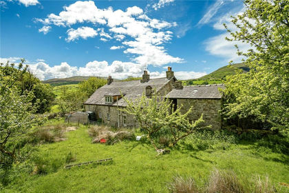
- Price
- Guide Price£350,000
- Size
- 16.63 acres
Added on 05/08/2026Agricultural Land Added on 29/01/2026Barn Conversion
- Price
- £485,000
- Size
- 1.5 acres
Sepia Barn, Main Street, Dent, LA10 5QL, Dent, Westmorland and Furness LA10 5QJ England
Added on 24/03/2026Barn Conversion
- Price
- Offers in Excess of£275,000
Added on 29/01/2026Development Land
- Price
- Offers in Excess of£435,000
- Size
- 0.25 acres
Station Road, Sedbergh, Cumbria, Sedbergh, Westmorland and Furness LA10 5HA England
Added on 29/01/2026Barn Conversion Added on 28/07/2026Barn Conversion
- Price
- £500,000
- Size
- 0.33 acres
Added on 30/04/2026Barn Conversion
- Price
- Guide Price£405,000
4 Norwood Farm Cottages, High Casterton, LA6 2SD, Casterton, Westmorland and Furness LA6 2SD England
Added on 25/03/2026Barn Conversion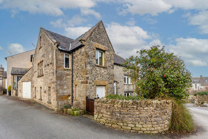
- Price
- £475,000
Added on 21/02/2026Residential Land