
Warren Lane, Ermington, Ivybridge, Devon, PL21
- Land size
- 3.08 acres
Key Features
- Building plot with full planning consent for demolition of an existing building and replacement with a substantial two-bed detached dwelling
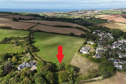
- 3.08 acres (1.25 hectares) of pasture
- Highly accessible position on the fringe of Ivybridge
- Attractive proposition for developers, investors or owner-occupiers seeking to create a contemporary home in a countryside setting
Description
A rare opportunity to acquire a development site in a highly accessible position on the fringe of Ivybridge, benefiting from full planning consent for the demolition of an existing building and replacement with a substantial two-bed detached dwelling. The property also includes approximately 3.08 acres (1.25 hectares) of pasture.
INTRODUCTION
An exciting opportunity to acquire a residential development site in a highly accessible position on the edge of Ivybridge, combining the potential to create a rural detached home with a generous area of adjoining pasture land. The property offers an attractive proposition for developers, investors or owner-occupiers seeking to create a contemporary home in a countryside setting with the convenience of being close to Ivybridge.
DESCRIPTION
The property comprises an existing agricultural building set within a rural location on the fringe of Ivybridge, together with approximately 3.08 acres (1.25 hectares) of pasture. The building benefits from planning consent for demolition and replacement with a substantial two-bedroom detached dwelling, with associated parking and amenity areas, offering purchasers the opportunity to create a well-proportioned home in an accessible countryside setting.
Superbly positioned on the fringe of Ivybridge, the site offers an ideal prospect for a self-builder or small developer to create a bespoke home, whilst remaining within easy reach of Ivybridge, the A38 and the wider amenities of Plymouth and the South Hams.
SITUATION
Ivybridge, often referred to as the ‘Gateway to the Moors’, is set on the foothills of Dartmoor National Park and is a popular and convenient place to live. Its excellent transport links include close proximity to the A38 dual carriageway, providing easy access to Plymouth to the west and the M5 at Exeter to the east.
The town offers a wealth of amenities, with most shops and services centred around Fore Street and Glanville’s Mill, the main shopping centre. Residents can enjoy a variety of independent shops, cafés, restaurants, and pubs, as well as scenic walks along the River Erme which winds through the town centre. The area is well served by local schools, with Ivybridge Community College being a highly regarded secondary school.
SERVICES
We understand mains single-phase electricity and mains water services are available on or near the property. Prospective purchasers must make their own enquiries to verify the availability and suitability of services.
DIRECTIONS
From the centre of Ivybridge, proceed west along the B3213 towards Plymouth and join the A38 westbound. Take the first exit, signposted Westlake, onto Hunsdon Road. Continue for approximately 0.1 miles before turning right at the junction onto Warren Lane. Continue for approximately 250 ft, where the property will be found on the right-hand side, identified by a GTH ‘For Sale’ board at the access gateway.
ADDITIONAL INFORMATION
Broadband: No investigations have been made into the available broadband connections; prospective purchasers are directed to make their own investigations.
Mobile Coverage: Available via EE, O2, THREE and VODAFONE. For an indication of specific speeds and supply or coverage in the area we recommend contacting your own provider.
Flooding: The property is at a VERY LOW RISK from River/Sea and Surface Water flooding
Rights & Restrictions: The property is offered for sale subject to and with the benefit of all matters contain in or referred to in the property charges register of the registered title, along with all public and private rights of way, wayleaves, easements and other rights of way whether specifically referred to or not. Specific rights are noted within these particulars.
Health & Safety: All persons wishing to view the property do so entirely at their own risk. Neither the Vendors or their Agents will be held liable for any damage or injury that may occur when visiting the property.
Tenure: The property is sold as freehold with the benefit of full vacant possession.
Local Authority: South Hams District Council - Follaton House, Plymouth Road, Totnes, Devon, TQ9 5NE. Tel: .
PLANNING CONSENT
Full planning permission has been granted by South Hams District Council under application reference 1868/25/FUL, dated 4 June 2026, for the demolition of the existing agricultural building and its replacement with a single-storey, two-bedroom detached dwelling.
The planning permission follows a previous approval under Class Q.
The approved scheme comprises a detached single-storey dwelling extending to approximately 95 sq m Gross Internal Area, together with associated vehicular access, parking, private residential curtilage and external works. The proposed accommodation provides two bedrooms alongside the principal living accommodation and is designed to make effective use of the existing developed footprint.
The proposals also incorporate a range of sustainable energy measures, including solar photovoltaic panels, an air source heat pump and electric vehicle charging provision.
We believe that all elements have been constructed with planning consent or have been in place for sufficient time that a certificate of lawful existing use could be secured.
Prospective buyers are urged to review the decision notice and officer’s report along with any related application documents, to have a thorough understanding of the consent granted.
DEVELOPMENT UPLIFT CLAUSE
The property will be sold subject to a Development Uplift Clause, providing for an agreed payment in the event of any future increase in value arising from additional development of the property.
The clause will apply to any future planning consent or development opportunity beyond the existing planning consent, which will be expressly excluded. Full details, including the trigger, percentage and duration, can be discussed with the selling agents.
METHOD OF SALE
The property is offered for sale by Private Treaty.
VIEWING
Strictly by appointment only with the agents.
Map Location
Property details
- Tenure
- Ask Agent
- Council Tax Band
- TBC
- Date Posted
- 2026-08-13
Market Value Analysis
Compared with 45 Building Plots listings in South West England (1+ acres).
Utilities & Restrictions
Utilities
- Electricity
- Ask Agent
- Water
- Ask Agent
- Heating
- Ask Agent
- Broadband
- Ask Agent
- Sewerage
- Ask Agent
Rights & Restrictions
- Public Rights of Way
- Ask Agent
- Private Rights of Way
- Ask Agent
- Listed Property
- Ask Agent
- Restrictions
- Ask Agent
Listed status, conservation areas and planning constraints for this location are in the full report.
Property Features
- Accessibility
- Ask Agent
- Parking
- Parking Available
- Garden
- Ask Agent
Beyond the particulars: planning activity, flood history, heritage and ground risks, checked for this exact spot.
Connectivity
Broadband
Fastest speed available at this postcode
80 Mbps
Superfast
Suitable for
- HD streaming
- Video calls
- Web & social
Fixed wireless access may also be an option here.
Mobile signal
Predicted 4G and 5G signal; indoor signal depends on building materials.
Ofcom Connected Nations postcode-level predictions. Speeds and signal are modelled, not measured, and vary between addresses and providers.
Signal is the easy part. Planning activity, flood history and protected designations here are in the full report.
Nearest Schools
Primary
- Woodlands Park Primary School0.8 milesOfsted: Good *
- Ages
- 4 to 11
- Pupils
- 324
- Type
- Academy converter
- Manor Primary School, Ivybridge1.1 milesOfsted: Good *
- Ages
- 2 to 11
- Pupils
- 190
- Type
- Academy converter
- The Erme Primary School1.4 milesOfsted report card · Mar 2026
- Ages
- 4 to 11
- Pupils
- 101
- Type
- Community school
- Stowford School1.7 milesNo Ofsted rating
- Ages
- 2 to 11
- Pupils
- 450
- Type
- Academy converter
- Ermington Primary School2.1 milesOfsted: Good
- Ages
- 4 to 11
- Pupils
- 85
- Type
- Academy converter
Secondary
- Ivybridge Community College1.6 milesOfsted: Good
- Ages
- 11 to 18
- Pupils
- 2,262
- Type
- Academy converter
- Plympton Academy4.5 milesOfsted: Requires improvement
- Ages
- 11 to 18
- Pupils
- 984
- Type
- Academy converter
- Hele's School5.2 milesNo Ofsted rating
- Ages
- 11 to 18
- Pupils
- 1,378
- Type
- Academy converter
- Coombe Dean School6 milesOfsted report card · Mar 2026
- Ages
- 11 to 18
- Pupils
- 1,000
- Type
- Academy converter
- Plymstock School6.3 milesOfsted: Good
- Ages
- 11 to 18
- Pupils
- 1,515
- Type
- Academy converter
* Latest graded judgement covers quality of education only; no overall grade was issued under the 2024-25 inspection framework.
Distances are straight-line from the advertised location. Source: the national school registers (DfE, Welsh Government, Scottish Government) and Ofsted.
Schools are just the start: sold prices nearby, planning activity and any flood history are in the full report.
Amenities
Supermarket
GP surgery
Pharmacy
Hospital
Green space
Straight-line distances from the advertised location. Sources: NHS records, Geolytix supermarket locations, OS Open Greenspace and the national trails registers.
The area stacks up? Now check the location itself: planning nearby, protected designations and past flooding.
Getting Around
Nearest station
Nearest bus stop
Typical drive times
Straight-line distances from the advertised location; drive times are typical free-flow times over OpenStreetMap road data, so allow more at peak. Public transport locations from DfT NaPTAN.
Easy to reach matters. So do planning activity, flood history and ground risks: all in the full report.
Flood Risk
Environment Agency open data, checked around the advertised map pin for the listed acreage. Long-term risk counts flood defences; the planning map's flood zones do not. Provided by LandSale, not the listing agent, and not part of the agent's particulars. Risk varies across a holding, so verify before committing.
Rivers and the sea
Planning map: Flood Zone 1.
Surface water
These bandings are the summary. Where this location sits on the flood maps, plus planning activity, heritage and ground risks, is in the full report.
Important notice: Information, maps and tags on this page are drawn from the advertising agent's marketing materials or generated automatically. LandSale has not verified them. Relying on these details is at your own risk, always carry out independent checks before committing to a purchase.
LandSale full disclaimer
Marketing information only - not formal particulars. The details on this website are provided for general guidance and do not constitute an offer or contract. Neither LandSale nor the advertising estate/land agent accepts responsibility for any inaccuracy.
1. Source of information
- Listing content: Core description, asking price, tenure, measurements, photographs and planning history originate from the marketing materials of the advertising estate or land agent. LandSale does not author this content and cannot guarantee its accuracy.
- Automated tags & categorisation: Property type, land-use class, acreage bands and similar labels may be applied by machine-learning models. They are intended as a helpful guide only and may not reflect the property's legal status or permitted use.
- Third-party & enriched data layers: Maps, boundary outlines, planning designations, soil reports, broadband coverage and other environmental or location-based insights are licensed from external suppliers. Such data are supplied “as is", may be incomplete or out of date and are subject to change without notice.
2. Verification required
Prospective purchasers must verify critical matters, including but not limited to planning permission, title boundaries, public rights of way, environmental constraints, acreage, services, access and VAT status, through their own inspections, specialist surveys, legal advisers and the selling agent before relying on the information or entering into any contract.
3. No warranty or liability
LandSale gives no warranty, express or implied, as to the accuracy, completeness or fitness for any particular purpose of the information displayed. LandSale shall not be liable for any loss, damage, cost or expense arising directly or indirectly from any use of or reliance on such information, save where liability may not be excluded by law.
4. Updates & feedback
If you believe any detail on this listing is inaccurate, please let us know. We will investigate and, where appropriate, update the listing or notify the agent.
© LandSale | Version 1.3 - August 2026
Listing agent
Greenslade Taylor Hunt, Ivybridge
8 Erme Ct Leonards Road, Ivybridge, PL21 0SZ
View agent profileSimilar properties for sale
- Price
- Guide Price£150,000
- Size
- 0.17 acres
Added on 14/09/2026Building Plot
- Price
- Guide Price£150,000
- Size
- 0.17 acres
Building Plot at South Milton, Kingsbridge, Devon TQ7, South Milton, Devon TQ7 England
Added on 15/09/2026Building Plot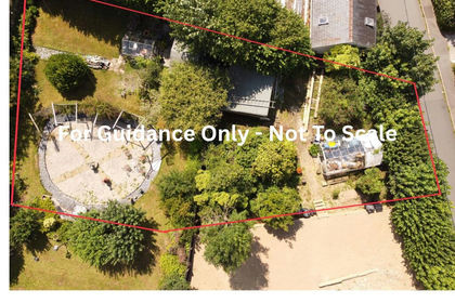
- Price
- Guide Price£160,000
Added on 06/03/2026Building Plot
- Price
- Guide Price£200,000
Old Milling Barn, Longcombe, Totnes, Berry Pomeroy, Devon TQ9 England
Added on 26/03/2026Barn
- Price
- Guide Price£175,000
- Size
- 0.35 acres
SINGLE BUILDING PLOT, Brixham Road, Paignton, Devon, TQ4, South Devon, Torbay TQ4 England
Added on 21/07/2026Self Build Plot
- Price
- Offers in Excess of£200,000
Added on 05/06/2026Building Plot
- Price
- From£120,000
Discounted Custom Build Dwellings, Howton Field, Newton Abbot, Newton Abbot, Devon TQ12 England
Added on 29/03/2026Self Build Plot Added on 29/01/2026Self Build Plot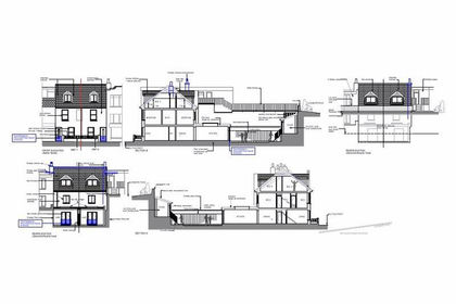
- Price
- £195,000
Added on 22/06/2026Development Land
- Price
- £150,000
Added on 04/07/2026Development LandLeasehold