
Barn and 2.64 acres of Land at Muckley Farm, Muckley, Acton Round, Bridgnorth
- Land size
- 2.64 acres
Key Features
- Traditional red brick barn with block lean-to
- Approximately 2.64 acres grassland
- Roadside access
- Potential for alternative use (STPP)
- Between Bridgnorth and Much Wenlock
- For sale by Public auction
Description
**Auction Guide Price £80,000 - £100,000**
Traditional brick barn with block lean-to, with potential for future alternative use (subject to planning permission), together with approx. 2.64 acres of grassland, in a popular rural area. For sale by Public Auction on 25th September 2026.
Situation - The property is located a short distance from the A458, on the edge of the rural hamlet of Muckley, which lies approximately 3 miles from Much Wenlock and 4 miles from Bridgnorth.
Description - The sale of the barn and land offers Purchasers the rare opportunity to acquire a traditional former agricultural building, along with 2.64 acres of grassland, with potential for a number of alternative uses, subject to planning permission.
The main barn is single storey and constructed of red brick under a tiled roof. It has a steel framed lean-to of block construction under a corrugated tin roof and a small, open concreted yard area with block walls and a sheeted gate.
Access is taken directly off the Muckley to Acton Round road which leads off the A458, via a double gateway.
The barn is situated within a grassland field of approximately 2.64 acres.
The barns have potential for a range of alternative uses (subject to obtaining the necessary planning permission). We advise all interested parties to make their own enquiries in this respect.
Services - We understand services are not connected and the purchaser will need to install their own services if required.
Tenure - The barn is freehold and vacant possession will be given on completion.
Rights Of Way, Easements And Wayleaves - The property will be sold subject to any wayleaves, public or private rights of way, easements and covenants and all outgoings whether mentioned in these sales particulars or not.
Boundaries, Fences And Roads - The Purchaser shall be deemed to have full knowledge of the boundaries and neither the Vendors nor their Agents will be responsible for defining any ownership of boundaries, hedges or fences. They will however provide whatever assistance they can to ascertain the ownership of the same.
Local Authority - Shropshire Council, The Guildhall, Frankwell Quay, Shrewsbury, SY3 8HQ
Planning - The property will be sold subject to any development plan, tree preservation order, town planning schedule, resolution or notice which may be or come to be in force, subject to any road or widening or improvement schemes, land charges and statutory or provisional by-laws, without any obligation on the Vendors to specify them.
Viewing - Viewings are by prior appointment with the selling Agents, Halls.
Sole Agents - Louise Preece, Halls Holdings Ltd, Halls Holdings House, Bowmen Way, Battlefield, Shrewsbury, Shropshire, SY4 3DR. Email: Tel:
Method Of Sale - The barn and land will be offered for sale by Public Auction on Friday 25th 2026 at Halls Holdings House, Bowmen Way, Battlefield, Shrewsbury, SY4 3DR at 2pm. The Auctioneers, as agents for the vendors, reserve the right to alter, divide, amalgamate or withdraw any of the property for sale at any time. The Auctioneers, further, reserve the right to sell the property privately, prior to Auction without prior notice or explanation and no liability will be accepted to any intending purchaser in consequence of such a decision.
Contracts And Legal Pack - The land will be sold subject to the Special Conditions of sale, which are not to be read at the time of sale, but will be available for inspection at the offices of the vendors' solicitors: Megan Jackson of FBC Manby Bowdler, Juneau House, Sitka Drive, Shrewsbury Business Park, Shrewsbury Tel: or email: megan. , or at Halls Head Office, Shrewsbury (Tel: ), prior to the date of the auction. The purchasers will be deemed to bid on those terms and conditions and shall be deemed to purchase with full knowledge thereof, whether he/she has read the Special Conditions of sale or not.
Guide Price/Reserve - Guides are provided as an indication of each sellers minimum expectation. They are not necessarily figures which a property will sell for and may change at any time prior to the auction. Each property will be offered subject to a reserve (a figure below which the Auctioneer cannot sell the property during the auction) which we expect will be set within the Guide Range or no more than 10% above a single figure guide.
Money Laundering Regulations - PLEASE NOTE that any person buying or bidding at auction MUST produce TWO forms of identification documentation. One to confirm their name and residential address, i.e, utility bill or bank statement and one photo ID, i.e, passport or driving licence. We will be unable to accept your bid unless you have registered with us and produced suitable ID.
Buyers Premium - In addition to the contract deposit required, buyers should note when bidding, that on the fall of the gavel, they will be responsible for paying a Buyer’s Premium. This is additional to the purchase price, is payable on the day of the auction, and is price structured as follows:
Sale price of £25,000 or more: 3.5% plus VAT, subject to a minimum fee of £4,000 plus VAT.
Sale price of £24,999 or less: fixed fee of £2,000 plus VAT.
This will apply if the land is sold before, at or after the Auction.
Bidding On Behalf Of Another Party - Where a person registers to bid on behalf of another individual or entity (the “Ultimate Purchaser”), the Auctioneers must be notified in advance of the auction. The bidder will be required to provide a valid, signed letter of authority from the Ultimate Purchaser confirming they are authorised to bid on their behalf. In addition, full identification and verification checks must be completed on the Ultimate Purchaser in accordance with anti-money laundering regulations prior to the auction. The individual attending and bidding must also produce satisfactory identification on the day. The Auctioneers reserve the right to refuse registration and/or any bid where these requirements have not been fully satisfied.
Map Location
Property details
- Tenure
- Freehold
- Council Tax Band
- Ask Agent
- Date Posted
- 2026-08-20
Market Value Analysis
Compared with 100 Development Land listings in West Midlands (1+ acres).
Utilities & Restrictions
Utilities
- Electricity
- Ask Agent
- Water
- Ask Agent
- Heating
- Ask Agent
- Broadband
- Ask Agent
- Sewerage
- Ask Agent
Rights & Restrictions
- Public Rights of Way
- Ask Agent
- Private Rights of Way
- Ask Agent
- Listed Property
- Ask Agent
- Restrictions
- Ask Agent
Listed status, conservation areas and planning constraints for this location are in the full report.
Property Features
- Accessibility
- Ask Agent
- Parking
- Parking Available
- Garden
- Garden
Beyond the particulars: planning activity, flood history, heritage and ground risks, checked for this exact spot.
Connectivity
Broadband
Fastest speed available at this postcode
9 Mbps
Under 10 Mbps here
Suitable for
- Basic browsing & email
Fixed wireless access may also be an option here.
Mobile signal
Predicted 4G and 5G signal; indoor signal depends on building materials.
Ofcom Connected Nations postcode-level predictions. Speeds and signal are modelled, not measured, and vary between addresses and providers.
Signal is the easy part. Planning activity, flood history and protected designations here are in the full report.
Nearest Schools
Primary
- Morville CofE (Controlled) Primary School2.2 milesOfsted: Good
- Ages
- 5 to 11
- Pupils
- 59
- Type
- Academy sponsor led
- Faith
- Church of England
- Much Wenlock Primary School2.5 milesOfsted report card · May 2026
- Ages
- 3 to 11
- Pupils
- 171
- Type
- Academy converter
- Barrow 1618 CofE Free School2.9 milesOfsted: Good
- Ages
- 4 to 11
- Pupils
- 93
- Type
- Free schools
- Faith
- Church of England
- Brockton CofE Primary School4.2 milesOfsted report card · Mar 2026
- Ages
- 2 to 11
- Pupils
- 51
- Type
- Voluntary controlled school
- Faith
- Church of England
- John Wilkinson Primary School and Nursery4.3 milesOfsted: Requires improvement
- Ages
- 2 to 11
- Pupils
- 162
- Type
- Academy converter
Secondary
- William Brookes School3.2 milesOfsted: Requires improvement
- Ages
- 11 to 16
- Pupils
- 748
- Type
- Academy converter
- Oldbury Wells School4.8 milesNo Ofsted rating
- Ages
- 11 to 16
- Pupils
- 740
- Type
- Academy converter
- Bridgnorth Endowed School4.8 milesOfsted: Good
- Ages
- 11 to 16
- Pupils
- 601
- Type
- Academy converter
- Haberdashers' Abraham Darby5.7 milesOfsted report card · Feb 2026
- Ages
- 11 to 18
- Pupils
- 1,084
- Type
- Academy sponsor led
- Madeley Academy6.6 milesOfsted: Good
- Ages
- 11 to 18
- Pupils
- 1,220
- Type
- Academy sponsor led
Distances are straight-line from the advertised location. Source: the national school registers (DfE, Welsh Government, Scottish Government) and Ofsted.
Schools are just the start: sold prices nearby, planning activity and any flood history are in the full report.
Amenities
Supermarket
GP surgery
Pharmacy
Hospital
Straight-line distances from the advertised location. Sources: NHS records, Geolytix supermarket locations, OS Open Greenspace and the national trails registers.
The area stacks up? Now check the location itself: planning nearby, protected designations and past flooding.
Getting Around
Nearest station
Nearest bus stop
Typical drive times
Straight-line distances from the advertised location; drive times are typical free-flow times over OpenStreetMap road data, so allow more at peak. Public transport locations from DfT NaPTAN.
Easy to reach matters. So do planning activity, flood history and ground risks: all in the full report.
Flood Risk
Environment Agency open data, checked around the advertised map pin for the listed acreage. Long-term risk counts flood defences; the planning map's flood zones do not. Provided by LandSale, not the listing agent, and not part of the agent's particulars. Risk varies across a holding, so verify before committing.
Rivers and the sea
Not at the pin: mapped about 50 metres away.
Planning map: Flood Zone 2.
Surface water
Not at the pin: mapped about 40 metres away.
These bandings are the summary. Where this location sits on the flood maps, plus planning activity, heritage and ground risks, is in the full report.
Important notice: Information, maps and tags on this page are drawn from the advertising agent's marketing materials or generated automatically. LandSale has not verified them. Relying on these details is at your own risk, always carry out independent checks before committing to a purchase.
LandSale full disclaimer
Marketing information only - not formal particulars. The details on this website are provided for general guidance and do not constitute an offer or contract. Neither LandSale nor the advertising estate/land agent accepts responsibility for any inaccuracy.
1. Source of information
- Listing content: Core description, asking price, tenure, measurements, photographs and planning history originate from the marketing materials of the advertising estate or land agent. LandSale does not author this content and cannot guarantee its accuracy.
- Automated tags & categorisation: Property type, land-use class, acreage bands and similar labels may be applied by machine-learning models. They are intended as a helpful guide only and may not reflect the property's legal status or permitted use.
- Third-party & enriched data layers: Maps, boundary outlines, planning designations, soil reports, broadband coverage and other environmental or location-based insights are licensed from external suppliers. Such data are supplied “as is", may be incomplete or out of date and are subject to change without notice.
2. Verification required
Prospective purchasers must verify critical matters, including but not limited to planning permission, title boundaries, public rights of way, environmental constraints, acreage, services, access and VAT status, through their own inspections, specialist surveys, legal advisers and the selling agent before relying on the information or entering into any contract.
3. No warranty or liability
LandSale gives no warranty, express or implied, as to the accuracy, completeness or fitness for any particular purpose of the information displayed. LandSale shall not be liable for any loss, damage, cost or expense arising directly or indirectly from any use of or reliance on such information, save where liability may not be excluded by law.
4. Updates & feedback
If you believe any detail on this listing is inaccurate, please let us know. We will investigate and, where appropriate, update the listing or notify the agent.
© LandSale | Version 1.3 - August 2026
Listing agent
Halls Estate Agents, Property Auctions & Rural Sales
Halls Holdings House Bowmen Way Battlefield Shrewsbury SY4 3DR
View agent profileSimilar properties for sale
- Price
- Offers in Region of£100,000
Building Plot Adjacent 78 Park Street Madeley Telford TF7, Madeley, Telford and Wrekin TF7 England
Added on 30/01/2026Building Plot
- Price
- Guide Price£70,000
The Rookery, Madeley, Madeley, Telford and Wrekin TF7 England
Added on 17/05/2026Building Plot
- Price
- Guide Price£90,000
- Size
- 0.2 acres
Added on 10/09/2026Barn
- Price
- Offers in Region of£135,000
Steventon New Road, Ludlow, SY8, Ludlow, Shropshire SY8 England
Added on 29/01/2026Building Plot
- Price
- Offers in Region of£130,000
Added on 29/01/2026Building Plot
- Price
- £125,000
Land Adjacent to 101 Hednesford Road, Cannock. WS11, Cannock Chase, Staffordshire WS11 England
Added on 08/07/2026Building Plot
- Price
- Offers in Region of£140,000
Added on 24/06/2026Development Land
- Price
- Guide Price£65,000
High Street, Pelsall, Walsall, Aldridge-Brownhills, Walsall WS3 England
Added on 10/09/2026Building Plot
- Price
- Offers in Region of£85,000
Added on 31/07/2026Building Plot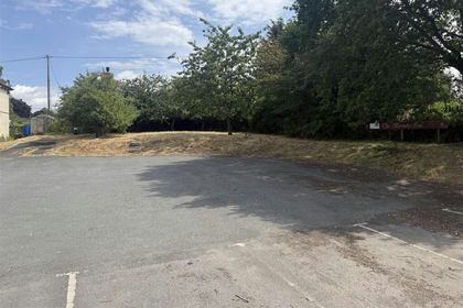
- Price
- Offers Over£100,000
- Size
- 0.2 acres
The Barneby Inn, Bredenbury, Bromyard, Bredenbury, Herefordshire, County of HR7 England
Added on 08/08/2026Building Plot