Lord Roberts Road, Beverley, East Riding Of Yorkshire
- Land size
- 2.1 acres
Key Features
- Allocated for mixed use inc. Housing development, allocation Bev-N for 25+ Homes
- Proposals invited on a conditional or unconditional basis
- Brownfield site extending to 0.85 Ha (2.1 Acres)
- Prime Location in Beverley
- Rare opportunity to acquire a town centre development site
Description
The opportunity includes both the former Minster Towers Care Home and 8 Lord Roberts Road. Minster Towers was built in the 1960’s and has been closed for a number of years. The brick and tile construction is mainly single storey.
The former care home site alone has an area of 0.46 Ha (1.14 acres). The building has a gross internal area of 1,360 sqm.
8 Lord Roberts Road is a two-storey red brick building with slate roof built in the 1930’s and last used as offices. The building occupies a site of 0.03 Ha (0.07 acres).
The total combined site area is 0.85 Ha (2.1 Acres), including the existing Council car park shaded pink and shown edged Red on the Plan. It is a condition of the sale that the Council retain a 50 space car park within the development. The precise configuration and location of the retained parking is to be agreed and examples of possible layouts are set out in Appendix B of the Marketing Pack (available upon request).
For indicative purposes only plans 2 & 3 in appendix B (See the Marketing Pack) show the creation of a new access from Minster Moorgate through adjoining Council land to allow the site to be sub-divided. Such proposals would be subject to consultation and would need to accommodate rights, access and parking for the adjacent Council properties.
PLANNING
The subject site is located within a Conservation Areas and has been subject to a recent planning application and appeal, both of which were refused. The reasons for refusal makes plain the conservation matters that any proposal will need to address.
The Council as vendor has obtained detailed planning guidance to aid with the sale and future development of the site. In summary, The Minster Towers site offers a rare and highly sensitive redevelopment opportunity within Beverley’s historic Conservation Area, with planning policy supporting a high-quality residential-led scheme alongside retained car parking. The planning guidance is set out at Appendix C.
Details of the original planning decision and appeal decision. Can be found via the public access website, reference; 22/03203/PLF and the Planning Inspectorate reference; App/E2001/W/25/3368783
LOCAL PLAN
The property forms part of allocation BEV-N – Land South of Lord Roberts Road, Beverley. The site is allocated for mixed use including housing development and car parking.
Proposals will be required to:
a) allow for the retention of the adjacent Grade II listed former chapel and it’s continuing use as a theatre;
b) provide for at least 50 car parking spaces; and
c) take account of the need to protect and enhance views of the Minster across and from within the site.
For further information on the Local Plan allocation, please visit;
SITE CONSTRAINTS
The Council has sought to provide sufficient information to enable interested parties to assess the opportunity. However, prospective purchasers must satisfy themselves through their own investigations, surveys and professional advice as to all matters affecting the property and any proposed development.
The site comprises previously developed land located within Beverley’s historic Conservation Area and in the setting of a number of important heritage assets, including the Grade II Listed former Baptist Chapel (now East Riding Theatre) and most notably the Grade I listed Beverley Minster. Development proposals will therefore need to carefully consider and respond to planning, heritage, design and townscape matters.
Public Conveniences
Immediately adjacent to the proposed development site is an existing Public Convenience building, which is to be retained and does not form part of the disposal.
The Council may, however, consider proposals aimed at modernising, upgrading, visually integrating or, where appropriate, re-providing the facility as part of a comprehensive redevelopment scheme, subject to all necessary approvals.
Asbestos
An asbestos survey has been undertaken in relation to the former Minster Towers Care Home and is available within the information pack.
Purchasers should satisfy themselves regarding the extent of any asbestos-related liabilities and the costs associated with management, removal or remediation.
Services and utilities
Interested parties should undertake their own investigations in respect of the location, capacity, condition and suitability of existing utility services and infrastructure serving the site. Any diversions, upgrades, disconnections or new service connections required as part of a proposed development shall be the responsibility of the purchaser.
Access and highways
Proposals must provide suitable access arrangements capable of accommodating the retained Council car park, the operational requirements of the East Riding Theatre and any proposed development. Final access arrangements will be subject to detailed design and approval through the planning and highways processes.
CONDITIONS & METHOD OF SALE
Proposals for the purchase and redevelopment of the site are invited.
The Council has deliberately adopted an Informal Tender process in recognition of the range of potential disposal, access and development solutions available, and wishes to encourage innovative proposals which maximise value whilst delivering an appropriate and sustainable form of development.
Proposals should be submitted using the prescribed Council Form, incorporating the following:
1. The precise identity of the purchaser (individual(s) or company name – inc. company number), plus the (registered) address
2. Contact number and email address
3. The level of offer (numerically and in writing,) with detail on how the purchase will be funded, alongside proof of funds
4. Details of bidder’s development experience and examples of comparable schemes
5. Details of Funding arrangements and evidence of financial standing
6. An outline of proposals for the property including sketch layouts and a statement setting out how the schemes will be compliant with planning requirements.
7. An outline of any conditions that are attached. (E.g unconditional or conditional bid, planning etc). With indications of timescale
8. Confirmation of the bidder’s willingness to assume responsibility for security. management and maintenance of the site during any conditional period.
Offers should only be posted using the return label incorporated within the form.
For a copy of the full Tender Pack or additional copies, please email nicholas. . Alternatively please call Valuation and Estates on
This is a unique and prestigious development opportunity to acquire a site for development within the town centre, close to the Council’s administrative offices and with fine views across to the historic Beverley Minster.
The Council will consider both conditional and unconditional offers. Where conditional offers are accepted, the Council may require provisions including long-stop dates, overage arrangements, buy-back rights and obligations relating to site security and management.
In assessing proposals, the Council will have regard to:
• the financial offer submitted;
• deliverability of the proposal;
• funding certainty;
• development experience and track record;
• planning and heritage considerations;
• proposed programme for delivery;
• alignment with the Council’s regeneration, placemaking and development objectives
• ability to manage and secure the site
Following review of proposals received, the Council may shortlist one or more parties and invite ‘Best and Final Offers’ prior to selection of a preferred purchaser. The Council reserves the right to negotiate with one or more parties at any stage of the process.
The Council reserves the right not to select a preferred bidder, not to proceed with any disposal and to amend the process at any time.
CLOSING DATE FOR OFFERS
The closing date for offers is 12 noon, Wednesday, 16 December 2026.
To ensure confidentiality of all parties, proposals should only be delivered using the return label at the rear of these particulars.
SECURITY AND MANAGEMENT DURING CONDITIONAL PERIOD
The Council will require the preferred bidder to immediately take over responsibility for the security, management, maintenance and protection of all vacant buildings and site during the period up to completion of the transaction.
The Council shall reserve the right to continue to use the forecourt parking until a sale progresses. The exact arrangements will be documented as part of the sale agreement and may include requirements for regular inspections, reporting and compliance with agreed site management procedures.
EPC
• The former Minster Towers Care Home is uninhabitable in its current condition and is exempt from EPC requirements.
• 8 Lord Roberts Road – awaiting confirmation.
COSTS
In addition to the purchase price the purchaser will be required to make a contribution of £5,000 (FIVE THOUSAND POUNDS) towards the Council’s selling costs, payable on exchange of contracts.
Thereafter, each party will be responsible for their own legal and professional costs incurred, with the purchaser responsible for any Stamp Duty Land Tax (SDLT) that may be payable.
BUSINESS RATES
Minster Towers is described as ‘Stores and Premises’ with a Rateable Value of £42,000 under the 2026 Rating list. The billing authority is East Riding of Yorkshire Council under billing reference BEV N.
8 Lord Roberts Road is described as ‘Offices and Premises’ with a Rateable Value of £12,000 under the 2026 Rating list. The billing authority is East Riding of Yorkshire Council under billing reference BEV N.
VAT
We understand that the property is not elected for VAT purposes.
WARRENTY
The information contained within these particulars is provided for guidance purposes only. The Council gives no warranty or representation regarding the suitability, deliverability or viability of any proposed development. Interested parties are responsible for undertaking their own legal, planning, financial, environmental and technical due diligence prior to submitting a proposal.
FURTHER INFORMATION & TO VIEW
A ‘data room’ summary of key information is available upon request incorporating the following;
• planning appeal decision;
• planning guidance note;
• building plans;
• room schedules;
• asbestos report;
• existing site plans;
• indicative access options;
• Informal Tender Submission form;
• EPC information.
Viewings are available strictly by appointment.
Map Location
Property details
- Tenure
- Freehold
- Council Tax Band
- Ask Agent
- Date Posted
- 2026-09-25
Utilities & Restrictions
Utilities
- Electricity
- Ask Agent
- Water
- Ask Agent
- Heating
- Ask Agent
- Broadband
- Ask Agent
- Sewerage
- Ask Agent
Rights & Restrictions
- Public Rights of Way
- Ask Agent
- Private Rights of Way
- Ask Agent
- Listed Property
- Ask Agent
- Restrictions
- Ask Agent
Listed status, conservation areas and planning constraints for this location are in the full report.
Property Features
- Accessibility
- Ask Agent
- Parking
- Ask Agent
- Garden
- Ask Agent
Beyond the particulars: planning activity, flood history, heritage and ground risks, checked for this exact spot.
Connectivity
Broadband
Fastest speed available at this postcode
1 Gbps
Gigabit full fibre
Suitable for
- 4K streaming on every screen
- Full-time home working
- Online gaming & big downloads
Mobile signal
Predicted 4G and 5G signal; indoor signal depends on building materials.
Ofcom Connected Nations postcode-level predictions. Speeds and signal are modelled, not measured, and vary between addresses and providers.
Signal is the easy part. Planning activity, flood history and protected designations here are in the full report.
Nearest Schools
Primary
- Beverley Minster CE Primary School684 metresOfsted: Requires improvement
- Ages
- 4 to 11
- Pupils
- 207
- Type
- Academy sponsor led
- Faith
- Church of England
- Keldmarsh Primary School839 metresOfsted report card · May 2026
- Ages
- 4 to 11
- Pupils
- 257
- Type
- Community school
- Beverley St Nicholas Primary School871 metresNo Ofsted rating
- Ages
- 3 to 11
- Pupils
- 287
- Type
- Academy converter
- Swinemoor Primary School0.7 milesNo Ofsted rating
- Ages
- 4 to 11
- Pupils
- 205
- Type
- Community school
- St John of Beverley Catholic Primary School - a Catholic voluntary academy0.7 milesOfsted: Good
- Ages
- 3 to 11
- Pupils
- 200
- Type
- Academy converter
- Faith
- Roman Catholic
Secondary
- Beverley High School714 metresOfsted: Outstanding
- Ages
- 11 to 18
- Pupils
- 821
- Type
- Community school
- Gender
- Girls
- Beverley Grammar School0.7 milesOfsted report card · Jan 2026
- Ages
- 11 to 18
- Pupils
- 829
- Type
- Academy converter
- Gender
- Boys
- Longcroft School and Sixth Form College1.1 milesOfsted: Good
- Ages
- 11 to 18
- Pupils
- 722
- Type
- Community school
- Cottingham High School3.6 milesOfsted report card · May 2026
- Ages
- 11 to 16
- Pupils
- 826
- Type
- Academy converter
- Sirius Academy North4.6 milesOfsted: Requires improvement *
- Ages
- 11 to 16
- Pupils
- 1,095
- Type
- Academy sponsor led
* Latest graded judgement covers quality of education only; no overall grade was issued under the 2024-25 inspection framework.
Distances are straight-line from the advertised location. Source: the national school registers (DfE, Welsh Government, Scottish Government) and Ofsted.
Schools are just the start: sold prices nearby, planning activity and any flood history are in the full report.
Amenities
Supermarket
GP surgery
Pharmacy
Hospital
Green space
Straight-line distances from the advertised location. Sources: NHS records, Geolytix supermarket locations, OS Open Greenspace and the national trails registers.
The area stacks up? Now check the location itself: planning nearby, protected designations and past flooding.
Getting Around
Nearest station
Nearest bus stop
Typical drive times
Straight-line distances from the advertised location; drive times are typical free-flow times over OpenStreetMap road data, so allow more at peak. Public transport locations from DfT NaPTAN.
Easy to reach matters. So do planning activity, flood history and ground risks: all in the full report.
Flood Risk
Environment Agency open data, checked around the advertised map pin for the listed acreage. Long-term risk counts flood defences; the planning map's flood zones do not. Provided by LandSale, not the listing agent, and not part of the agent's particulars. Risk varies across a holding, so verify before committing.
Rivers and the sea
Planning map: Flood Zone 1.
Surface water
Not at the pin: mapped about 20 metres away.
These bandings are the summary. Where this location sits on the flood maps, plus planning activity, heritage and ground risks, is in the full report.
Important notice: Information, maps and tags on this page are drawn from the advertising agent's marketing materials or generated automatically. LandSale has not verified them. Relying on these details is at your own risk, always carry out independent checks before committing to a purchase.
LandSale full disclaimer
Marketing information only - not formal particulars. The details on this website are provided for general guidance and do not constitute an offer or contract. Neither LandSale nor the advertising estate/land agent accepts responsibility for any inaccuracy.
1. Source of information
- Listing content: Core description, asking price, tenure, measurements, photographs and planning history originate from the marketing materials of the advertising estate or land agent. LandSale does not author this content and cannot guarantee its accuracy.
- Automated tags & categorisation: Property type, land-use class, acreage bands and similar labels may be applied by machine-learning models. They are intended as a helpful guide only and may not reflect the property's legal status or permitted use.
- Third-party & enriched data layers: Maps, boundary outlines, planning designations, soil reports, broadband coverage and other environmental or location-based insights are licensed from external suppliers. Such data are supplied “as is", may be incomplete or out of date and are subject to change without notice.
2. Verification required
Prospective purchasers must verify critical matters, including but not limited to planning permission, title boundaries, public rights of way, environmental constraints, acreage, services, access and VAT status, through their own inspections, specialist surveys, legal advisers and the selling agent before relying on the information or entering into any contract.
3. No warranty or liability
LandSale gives no warranty, express or implied, as to the accuracy, completeness or fitness for any particular purpose of the information displayed. LandSale shall not be liable for any loss, damage, cost or expense arising directly or indirectly from any use of or reliance on such information, save where liability may not be excluded by law.
4. Updates & feedback
If you believe any detail on this listing is inaccurate, please let us know. We will investigate and, where appropriate, update the listing or notify the agent.
© LandSale | Version 1.3 - August 2026
Listing agent
East Riding of Yorkshire Council, Beverley
County Hall, Beverley, East Riding, HU17 9BA
Contact East Riding of Yorkshire Council, Beverley
County Hall, Beverley, East Riding, HU17 9BA
View agent profileSimilar properties for sale
- Price
- Offers in Excess of£1,500,000
- Size
- 3.9 acres
Added on 23/09/2026Redevelopment Land
- Price
- Sale by Tender£900,000
- Size
- 3.11 acres
Added on 18/07/2026Redevelopment Land
- Price
- Guide Price£570,000
- Size
- 1 acres
Added on 22/06/2026Development Land
- Price
- Guide Price£950,000
- Size
- 2.99 acres
Cottage Farmstead, Crowle, North Lincs, Crowle and Ealand, North Lincolnshire DN17 England
Added on 29/01/2026Development Land
- Price
- £550,000
- Size
- 1.2 acres
Mill Road, Crowle, Crowle and Ealand, North Lincolnshire DN17 England
Added on 23/05/2026Development Land- Price
- £550,000
- Size
- 1.2 acres
Mill Road, Crowle, Crowle and Ealand, North Lincolnshire DN17 England
Added on 23/05/2026Development Land
- Price
- Guide Price£650,000
- Size
- 1 acres
Scagglethorpe, Malton, YO17, Scagglethorpe, North Yorkshire YO17 England
Added on 07/03/2026Development Land
- Price
- POA
- Size
- 2.52 acres
Added on 09/09/2026Development Land
- Price
- Guide Price£1,750,000
- Size
- 4.06 acres
Added on 09/06/2026Development Land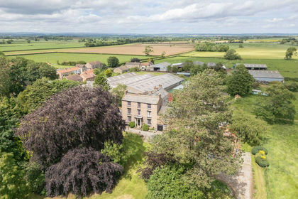
- Price
- Offers Over£1,800,000
- Size
- 14.5 acres
Added on 26/07/2026Development Land