Wayleaves, Monkokehampton, Winkleigh, EX19
- Land size
- 0.3 acres
Key Features
- Planning permission for four new homes
- Mix of 2 and 3 bedroom houses
- Quiet edge-of-village setting
- Lovely countryside views
- Gardens and parking for each plot
- Near Hatherleigh and Okehampton
- Perfect for a small developer
Description
This development site sits on the edge of Monkokehampton, a quiet village in West Devon, with open countryside on all sides and the market towns of Hatherleigh and Okehampton both within easy reach.
Outline planning permission has been granted for four new homes: two three-bedroom houses of approximately 90sqm and two two-bedroom houses of approximately 79sqm, arranged as two semi-detached pairs. Each pair has its own access from one of two quiet village lanes bordering the site. Planning references 2280/23/OPA and 0599/25/OPA cover both schemes, with access, layout and scale already approved. Full details are on the West Devon Borough Council planning portal.
The site extends to approximately 0.3 acres and adjoins a bungalow known as Wayleaves. Each plot has space for its own garden and parking, and the gentle slope of the land means the finished homes should enjoy open views over the surrounding fields.
The central garden ground between the two plots is included in the sale, removing the previous pedestrian right of way that crossed the site. The buyer will be required to construct the retaining wall along the boundary with Wayleaves, as shown on the planning drawings. Final layouts, finishes and landscaping remain subject to reserved matters approval.
Monkokehampton has a 19th century church, footpaths into open countryside and easy access to Dartmoor. Hatherleigh is about three miles away for everyday needs, Okehampton around ten miles with supermarkets, schools, a medical centre and a railway station with services to Exeter. Primary schools at Exbourne, Hatherleigh and Winkleigh are all within roughly five to ten miles.
This is a straightforward opportunity for a small developer or builder looking for a manageable scheme with planning already in place in a part of Devon that rarely sees sites of this kind come to market. Offered as a single lot.
Broadband: Standard (source: Ofcom) Drainage: See planning Tenure: Freehold
Buyers' Compliance Fee: A compliance check fee of £25 inc. VAT per person is payable on acceptance of an offer, covering ID verification and anti-money laundering checks as required by law.
Directions: Satnav: EX19 8SE ///superbly.deflate.swells
Map Location
Property details
- Tenure
- Freehold
- Council Tax Band
- A
- Date Posted
- 2026-01-29
Utilities & Restrictions
Utilities
- Electricity
- Ask Agent
- Water
- Ask Agent
- Heating
- Ask Agent
- Broadband
- Ask Agent
- Sewerage
- Ask Agent
Rights & Restrictions
- Public Rights of Way
- Ask Agent
- Private Rights of Way
- Ask Agent
- Listed Property
- Ask Agent
- Restrictions
- Ask Agent
Property Features
- Accessibility
- Ask Agent
- Parking
- Parking Available
- Garden
- Garden
Important notice: Information, maps and tags on this page are supplied by the advertising agent or generated automatically. LandSale has not verified them. Relying on these details is at your own risk, always carry out independent checks before committing to a purchase.
LandSale full disclaimer
Marketing information only - not formal particulars. The details on this website are provided for general guidance and do not constitute an offer or contract. Neither LandSale nor the advertising estate/land agent accepts responsibility for any inaccuracy.
1. Source of information
- Agent-supplied content: Core description, asking price, tenure, measurements, photographs and planning history are uploaded by the appointed agent, who remains solely responsible for their accuracy.
- Automated tags & categorisation: Property type, land-use class, acreage bands and similar labels may be applied by machine-learning models. They are intended as a helpful guide only and may not reflect the property's legal status or permitted use.
- Third-party & enriched data layers: Maps, boundary outlines, planning designations, soil reports, broadband coverage and other environmental or location-based insights are licensed from external suppliers. Such data are supplied “as is", may be incomplete or out of date and are subject to change without notice.
2. Verification required
Prospective purchasers must verify critical matters, including but not limited to planning permission, title boundaries, public rights of way, environmental constraints, acreage, services, access and VAT status, through their own inspections, specialist surveys, legal advisers and the selling agent before relying on the information or entering into any contract.
3. No warranty or liability
LandSale gives no warranty, express or implied, as to the accuracy, completeness or fitness for any particular purpose of the information displayed. LandSale shall not be liable for any loss, damage, cost or expense arising directly or indirectly from any use of or reliance on such information, save where liability may not be excluded by law.
4. Updates & feedback
If you believe any detail on this listing is inaccurate, please let us know. We will investigate and, where appropriate, update the listing or notify the agent.
© LandSale | Version 1.2 - January 2026
Listing agent
Helmores, Crediton
111-112 High Street, Crediton, Devon, EX17 3LF
Similar properties for sale

- Price
- From£195,000
- Size
- 0.34 acres
Added on 29/01/2026Building Plot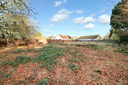
- Price
- Offers in Region of£175,000
- Size
- 0.21 acres
Building Plot, Back Lane, Chulmleigh, Devon, EX18, Chulmleigh, Devon EX18 7DL England
Added on 29/01/2026Building Plot
- Price
- Guide Price£150,000
Crowbeare Meadow, Torrington, Devon, Great Torrington, Devon EX38 7DW England
Added on 29/01/2026Development Land
- Price
- Offers in Region of£150,000
- Size
- 0.19 acres
SELF BUILD PLOT, Chulmleigh Road, Morchard Bishop, EX17, Morchard Bishop, Devon EX17 6FR England
Added on 29/01/2026Self Build Plot
- Price
- Offers in Region of£150,000
- Size
- 0.33 acres
Added on 20/07/2026Building Plot
- Price
- Guide Price£165,000
- Size
- 0.25 acres
Added on 29/01/2026Building Plot Added on 29/01/2026Development Land
- Price
- Offers in Region of£180,000
- Size
- 0.4 acres
Codden Hill, Bishops Tawton, Bishop's Tawton, Devon EX32 0EN England
Added on 24/02/2026Building Plot
- Price
- Guide Price£135,000
- Size
- 0.55 acres
Pyworthy, Holsworthy, EX22, Pyworthy, Devon EX22 6JY England
Added on 28/04/2026Building Plot
- Price
- Guide Price£225,000
- Size
- 0.24 acres
42 High Street, St Saviours Way, Crediton, Devon, EX17 3PJ, Crediton, Devon EX17 3PJ England
Added on 29/01/2026Development Land