Finchdean Road, Waterlooville, Hampshire, PO8
- Land size
- 6.74 acres
Key Features
- SEE AND PRINT PDF SALES PARTICULARS AVAILABLE BELOW
- SEE DRONE VIDEO FOOTAGE ON THE VIRTUAL TOUR TAB
- EQUESTRIAN HOLDING EXTENDING TO 6.74 ACRES
- INCLUDES 5.12 ACRES OF ESTABLISHED PASTURE
- SET WITHIN THE SOUTH DOWNS NATIONAL PARK
- WELL-EQUIPPED YARD WITH FIVE STABLES & 2 HAY/FEED STORES
- ALL-WEATHER ARENA (60M X 20M)
- PADDOCKS & 4 FIELD SHELTERS
- DIRECT ACCESS TO NEARBY BRIDLEWAYS
- OFF-GRID SERVICES INCLUDE SOLAR POWER, WATER STORAGE & DRAINAGE
Description
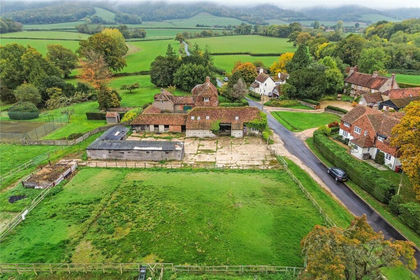
Attractive equestrian holding extending to approximately 6.74 acres, including 5.12 acres of established pasture, set within the South Downs National Park, with a beautiful rural outlook.
Comprising a well-equipped yard with five stables (4x 12ft x 12ft and 1x 16ft x 12ft), 60m x 20m all-weather arena and paddocks, with direct access to nearby bridleways. Accessed via a private track from Finchdean Road and benefiting from off-grid services including solar power, water storage and drainage. A ready-made private equestrian holding in a highly desirable downland setting.
VIEWING INSTRUCTIONS: Strictly by appointment only. It is essential to view the drone video footage available at the Selling Agent's website, prior to visiting the Property.
LOCATION: See Location Plan. Finchdean Lane, Waterlooville, Hampshire, PO8 0AP. What3Words: refills.towels.buckling
The property is situated in an attractive rural position within the South Downs National Park, forming part of the South Downs Local Character Area. The land enjoys a particularly appealing countryside outlook and is bordered to the west by Chalton Down Local Wildlife Site, which is also designated common land, enhancing the setting and amenity value. The surrounding area is highly regarded for equestrian use, with excellent access to nearby bridleways and riding routes across the South Downs.
DIRECTIONS: From Finchdean Road, the property is accessed via a short private accessway (shared with one neighbouring agricultural property). Please refer to the Location Plan and What3Words reference.
DESCRIPTION: An attractive and well-equipped private equestrian holding extending to approximately 6.74 acres (2.73 hectares), including 5.12 acres of pastureland, together with a comprehensive range of equestrian facilities. The property has been arranged as a practical smallholding, with the land divided into paddocks with a yard area, providing a functional and well-contained layout. The yard includes a timber stable block comprising five loose boxes (four 12ft x 12ft and one 16ft x 12ft foaling box), together with two hay/feed stores, wash-down area and associated hardstanding. A 60m x 20m all-weather arena (sand and fibre surface) with mirrors is positioned adjacent to the yard, providing excellent year-round riding conditions. Additional improvements include a secure shipping container, parking area and ancillary structures.
THE LAND: The pastureland extends to approximately 5.12 acres, forming part of the overall 6.74 acre holding, and is divided into a number of well-fenced paddocks. The land is generally level to gently undulating and well suited to equestrian grazing, benefitting from four field shelters and water provision within the paddocks. The Agricultural Land Classification indicates that the land is predominantly Grade 3 and Grade 4, with the western areas comprising shallow lime-rich soils over chalk or limestone and the eastern areas comprising freely draining lime-rich loamy soils. This soil profile is typical of the South Downs and is well suited to grazing and equestrian use.
EQUESTRIAN FACILITIES
- Timber stable block (5 boxes - 4x 12ft x12ft, 1x 16ft x12ft foaling box)
- 2 hay/feed stores
- Wash-down area
- 60m x 20m arena (sand and fibre surface) with mirrors
- Secure shipping container
- Hardstanding yard and parking area
- 4 field shelters
ACCESS & RIGHTS OF WAY: Access is taken via a short private track from Finchdean Road, shared with one neighbouring agricultural property. Although owned with the land, the Land Registry Title confirms third party rights of access over the entrance route to access neighbouring land to the west. A public footpath (Ref: 052/16/1) passes close to the access westwards across the Downs.
PLANNING: The property lies within the South Downs National Park, outside of settlement boundaries; therefore, the planning policies are restrictive as regards the types of development that can be achieved. A number of planning permissions have been granted in respect of the property, confirming its established equestrian use, including:
SDNP/16/00998/FUL - Retention of stable block, tack room, feed store and toilets (Approved)
SDNP/15/04580/FUL- Outdoor riding arena (Approved)
SDNP/16/02285/FUL- Timber framed & clad hay, straw & grassland equipment storage barn (Approved).
A further application (SDNP/15/01960/FUL) for an open-air riding arena was withdrawn. A mobile home and separate welfare unit (toilet/shower) are currently on site and have been in situ for a number of years but do not benefit from planning permission and are sold as seen.
SERVICES:
- Rainwater harvesting system (approx. 20,000 litres)
- Solar power system with battery storage and inverter
- Generator back-up
- Septic tank (no mains drainage)
- LPG supply to welfare unit
- Mobile signal booster and security cameras
- No mains electricity connected.
DESIGNATIONS: The Property is situated within the South Downs National Park and the South Downs Local Character Area. It is also adjacent to Chalton Down Local Wildlife Site (Common Land).
LAND REGISTRY: The property entirety of Land Registry Title No. HP416335. The title includes rights reserved for access over the entranceway in common with adjoining land. Copies Available on Selling Agents Website.
TENURE: Freehold with vacant possession on completion.
BUSINESS RATES: Not currently demanded or assessed.
LOCAL AUTHORITY: East Hampshire District Council, PO Box 310, Petersfield, Hampshire, GU32 9HN. Tel:
PLANNING AUTHORITY: South Downs National Park (SDNP), South Downs Centre, North Street, Midhurst, West Sussex, GU29 9DH
Map Location
Property details
- Tenure
- Freehold
- Council Tax Band
- Ask Agent
- Date Posted
- 2026-03-21
Market Value Analysis
Compared with 80 Equestrian listings in South East England (5+ acres).
Utilities & Restrictions
Utilities
- Electricity
- Ask Agent
- Water
- Ask Agent
- Heating
- Ask Agent
- Broadband
- Ask Agent
- Sewerage
- Ask Agent
Rights & Restrictions
- Public Rights of Way
- Ask Agent
- Private Rights of Way
- Ask Agent
- Listed Property
- Ask Agent
- Restrictions
- Ask Agent
Property Features
- Accessibility
- Ask Agent
- Parking
- Parking Available
- Garden
- Garden
Important notice: Information, maps and tags on this page are supplied by the advertising agent or generated automatically. LandSale has not verified them. Relying on these details is at your own risk, always carry out independent checks before committing to a purchase.
LandSale full disclaimer
Marketing information only - not formal particulars. The details on this website are provided for general guidance and do not constitute an offer or contract. Neither LandSale nor the advertising estate/land agent accepts responsibility for any inaccuracy.
1. Source of information
- Agent-supplied content: Core description, asking price, tenure, measurements, photographs and planning history are uploaded by the appointed agent, who remains solely responsible for their accuracy.
- Automated tags & categorisation: Property type, land-use class, acreage bands and similar labels may be applied by machine-learning models. They are intended as a helpful guide only and may not reflect the property's legal status or permitted use.
- Third-party & enriched data layers: Maps, boundary outlines, planning designations, soil reports, broadband coverage and other environmental or location-based insights are licensed from external suppliers. Such data are supplied “as is", may be incomplete or out of date and are subject to change without notice.
2. Verification required
Prospective purchasers must verify critical matters, including but not limited to planning permission, title boundaries, public rights of way, environmental constraints, acreage, services, access and VAT status, through their own inspections, specialist surveys, legal advisers and the selling agent before relying on the information or entering into any contract.
3. No warranty or liability
LandSale gives no warranty, express or implied, as to the accuracy, completeness or fitness for any particular purpose of the information displayed. LandSale shall not be liable for any loss, damage, cost or expense arising directly or indirectly from any use of or reliance on such information, save where liability may not be excluded by law.
4. Updates & feedback
If you believe any detail on this listing is inaccurate, please let us know. We will investigate and, where appropriate, update the listing or notify the agent.
© LandSale | Version 1.2 - January 2026
Listing agent
Giles Wheeler-Bennett, Southampton
West Court, Lower Basingwell Street, Bishop's Waltham, SO32 1AJ
Contact Giles Wheeler-Bennett, Southampton
West Court, Lower Basingwell Street, Bishop's Waltham, SO32 1AJ
View agent profileSimilar properties for sale
- Price
- Guide Price£500,000
- Size
- 5 acres
Hoyle Lane, Heyshott, GU29, Heyshott, West Sussex GU29 0DX England
Added on 04/07/2026Equestrian property
- Price
- Guide Price£650,000
- Size
- 12 acres
Chilling Lane, Warsash, Hamble Valley, Hampshire SO31 9HF England
Added on 22/06/2026Equestrian propertyLeasehold
- Price
- £675,000
- Size
- 5 acres
Romsey Road, Ower, SO51, Netley Marsh, Hampshire SO51 6AH England
Added on 29/01/2026Equestrian property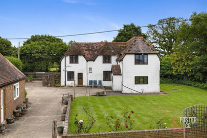
- Price
- Offers in Excess of£795,000
- Size
- 3.6 acres
Wheatsheaf Road, Wineham, Henfield, Shermanbury, West Sussex BN5 9BE England
Added on 15/07/2026Equestrian property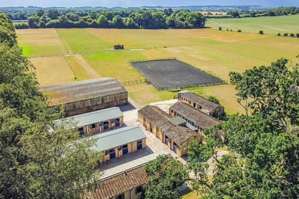
- Price
- £795,000
- Size
- 24.18 acres
Added on 11/07/2026Equestrian property
- Price
- £695,000
- Size
- 5 acres
Bridge Way, Cobham, Surrey, KT11, Runnymede and Weybridge, Surrey KT11 1HL England
Added on 31/01/2026Development Land
- Price
- Guide Price£765,000
- Size
- 4.75 acres
Rockbourne Road, Sandleheath, Fordingbridge, Hampshire, SP6, Sandleheath, Hampshire SP6 1RA England
Added on 10/05/2026Cottage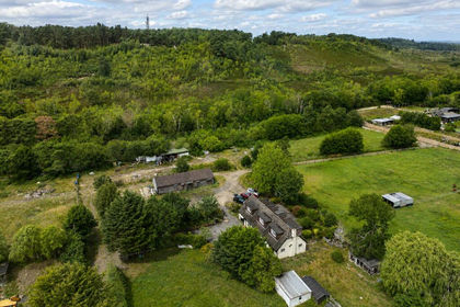
- Price
- Guide Price£775,000
- Size
- 4.75 acres
Added on 15/07/2026House with Land