Kettleburgh, Nr Framlingham, Suffolk
- Land size
- 0.75 acres
- Bedrooms
- 4
- Bathrooms
- 4
Description
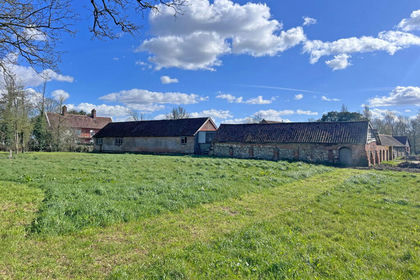
A Suffolk barn with planning permission to be converted to a contemporary dwelling of approximately 3,100 sq. ft to comprise a hall, open plan kitchen/dining/living, utility room, boot room, snug, shower room, four ground floor bedrooms with a bathroom and en-suite, along with a first floor principal bedroom with en-suite bathroom. Grounds extending to 0.75 acres.
Location
Rookery Farm Barn is situated between the village of Kettleburgh and the town of Framlingham. Kettleburgh has a sought after public house, The Chequers. Within 2 miles is Framlingham where there are a good selection of independent shops and businesses including cafés, restaurants, hairdressers, antique shops, a travel agency, doctors surgery, vets and delicatessen. It is also home to the Crown Hotel, a Co-operative supermarket, Primary School, High School and Framlingham College.
Directions
From Framlingham proceed in a southerly direction along Station Road and turn right towards Kettleburgh. After approximately 1.5 miles, Rookery Farm Barn will be found on the right hand side.
What3Words: ///realm.outraged.steaming
Framlingham is surrounded by delightful villages, many of which have popular public houses. The surrounding countryside has amenities such as golf at Woodbridge (12 miles) and Aldeburgh (13 miles). The world famous Snape Maltings Concert Hall is within easy reach (10.5 miles). There is also bird watching at the RSPB centre at Minsmere (15 miles). The county town of Ipswich lies approximately 18 miles to the south-west and from here there are regular services to London’s Liverpool Street station.
Description
East Suffolk Council granted planning permission for the conversion of the barn under reference DC/24/3501/FUL on 6th March 2025. Some of the associated plans are included within the particulars but further documents, including the planning permission are available from the East Suffolk Council planning website. The permission allows for the conversion of the barn to form a residential dwelling. The barn stands in grounds of 0.75 acres.
Services
It is understood that mains electricity is connected to the property. The property has a right to connect to the neighbours water supply and to install a sub-meter. There is no mains drainage and a buyer will need to install a sewage treatment plant with the appropriate rights to be provided for clean water discharge as required. It is understood that there is phone/broadband in the immediate vicinity. Interested parties should carry out their own investigations with regard to services.
Plans and CGIs
The plans and CGIs are kindly provided by Plaice Design Co Ltd. The architects will be pleased to speak to interested parties about the design and providing a quote to obtain building regulations and to manage the project. They can be contacted on or .
Local Authority East Suffolk Council; East Suffolk House, Station Road, Melton, Woodbridge, Suffolk IP12 1RT; Tel: .
Community Infrastructure Levy (CIL) An incoming purchaser will be liable for any Community Infrastructure Levy (CIL) which is currently set at £75,746.06. It is understood that this figure is index linked. However, it may be possible for an owner/builder to apply for an exemption. Interested parties should carry out their own research with regard to CIL.
Biodiversity Nett Gain (BNG) It is understood that the site is subject to BNG and interested parties are responsible for any costs/works.
Viewing Please contact Clarke and Simpson to inform of your intention to view the property.
NOTES
1. Every care has been taken with the preparation of these particulars, but complete accuracy cannot be guaranteed. If there is any point, which is of particular importance to you, please obtain professional confirmation. Alternatively, we will be pleased to check the information for you. These Particulars do not constitute a contract or part of a contract. All measurements quoted are approximate. The Fixtures, Fittings & Appliances have not been tested and therefore no guarantee can be given that they are in working order. Photographs are reproduced for general information and it cannot be inferred that any item shown is included. No guarantee can be given that any planning permission or listed building consent or building regulations have been applied for or approved. The agents have not been made aware of any covenants or restrictions that may impact the property, unless stated otherwise. Any site plans used in the particulars are indicative only and buyers should rely on the Land Registry/transfer plan.
2. The Money Laundering, Terrorist Financing and Transfer of Funds (Information on the Payer) Regulations 2017 require all Estate Agents to obtain sellers’ and buyers’ identity.
3. The size of the buildings referred to in the particulars is a guide only and interested parties should undertake their own investigations in this regard.
4. Some images within the particulars are CGIs of the proposed development.
5. A site plan of what is being sold is included in these particulars with the property outlined in red. The retained property will have right of way over and right to lay/retain services through the land shaded blue.
March 2026
Map Location
Property details
- Tenure
- Freehold
- Council Tax Band
- Ask Agent
- Date Posted
- 2026-04-02
Utilities & Restrictions
Utilities
- Electricity
- Mains
- Water
- Ask Agent
- Heating
- Ask Agent
- Broadband
- Ask Agent
- Sewerage
- Ask Agent
Rights & Restrictions
- Public Rights of Way
- Ask Agent
- Private Rights of Way
- Ask Agent
- Listed Property
- Ask Agent
- Restrictions
- Ask Agent
Property Features
- Accessibility
- Ask Agent
- Parking
- Off-Street Parking
- Garden
- Private Garden
Important notice: Information, maps and tags on this page are supplied by the advertising agent or generated automatically. LandSale has not verified them. Relying on these details is at your own risk, always carry out independent checks before committing to a purchase.
LandSale full disclaimer
Marketing information only - not formal particulars. The details on this website are provided for general guidance and do not constitute an offer or contract. Neither LandSale nor the advertising estate/land agent accepts responsibility for any inaccuracy.
1. Source of information
- Agent-supplied content: Core description, asking price, tenure, measurements, photographs and planning history are uploaded by the appointed agent, who remains solely responsible for their accuracy.
- Automated tags & categorisation: Property type, land-use class, acreage bands and similar labels may be applied by machine-learning models. They are intended as a helpful guide only and may not reflect the property's legal status or permitted use.
- Third-party & enriched data layers: Maps, boundary outlines, planning designations, soil reports, broadband coverage and other environmental or location-based insights are licensed from external suppliers. Such data are supplied “as is", may be incomplete or out of date and are subject to change without notice.
2. Verification required
Prospective purchasers must verify critical matters, including but not limited to planning permission, title boundaries, public rights of way, environmental constraints, acreage, services, access and VAT status, through their own inspections, specialist surveys, legal advisers and the selling agent before relying on the information or entering into any contract.
3. No warranty or liability
LandSale gives no warranty, express or implied, as to the accuracy, completeness or fitness for any particular purpose of the information displayed. LandSale shall not be liable for any loss, damage, cost or expense arising directly or indirectly from any use of or reliance on such information, save where liability may not be excluded by law.
4. Updates & feedback
If you believe any detail on this listing is inaccurate, please let us know. We will investigate and, where appropriate, update the listing or notify the agent.
© LandSale | Version 1.2 - January 2026
Listing agent
Clarke and Simpson, Framlingham
Well Close Square, Framlingham, IP13 9DU
Similar properties for sale
- Price
- Guide Price£350,000
- Size
- 0.75 acres
Kettleburgh, Nr Framlingham, Suffolk, Kettleburgh, Suffolk IP13 7LL England
Added on 21/07/2026Development Land
- Price
- Guide Price£375,000
- Size
- 0.49 acres
Hacheston, Nr Woodbridge, Suffolk, Hacheston, Suffolk IP13 0DX England
Added on 01/05/2026Self Build Plot
- Price
- Guide Price£325,000
- Size
- 0.4 acres
Sevengardens Road, Burgh, Woodbridge, Suffolk, IP13, Burgh, Suffolk IP13 6SX England
Added on 15/02/2026Building Plot Added on 26/03/2026Self Build Plot
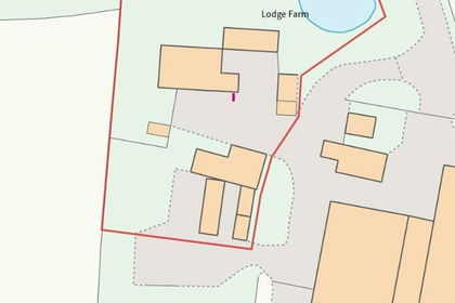
- Price
- Guide Price£275,000
- Size
- 0.6 acres
Added on 28/06/2026Development Land
- Price
- Guide Price£425,000
Little Bealings, Nr Woodbridge, Suffolk, Little Bealings, Suffolk IP13 6LW England
Added on 29/01/2026Development Land
- Price
- Guide Price£425,000
- Size
- 2 acres
Witnesham, Nr Ipswich, Suffolk, Witnesham, Suffolk IP6 9HL England
Added on 17/05/2026Building Plot
- Price
- Guide Price£275,000
Lower Road, Westerfield, Ipswich, Suffolk, IP6, Westerfield, Suffolk IP6 9AR England
Added on 29/01/2026Building Plot
- Price
- Guide Price£400,000
Hollesley, Woodbridge, IP12, Hollesley, Suffolk IP12 3RR England
Added on 30/04/2026Development Land
- Price
- Guide Price£395,000
Added on 29/01/2026Building Plot