St Teath, Bodmin
- Land size
- 0.5 acres
Key Features
- Pair of Traditional Barns
- Conditional Planning for Dwelling and Annexe
- 0.5 Acre Paddock
Description
An increasingly rare opportunity to purchase a pair of traditional Cornish farm barns, part of one being a former corn mill with existing slate sluice and dilapidated water wheel. Both barns with the benefit of conditional detailed planning permission for conversion, the larger to a three bedroom dwelling and the smaller to a two bedroom annexe, together with a very attractive, elongated and tree-lined paddock.
The Barns
The barns are located at the edge of the farmstead at Trekee Farm, with long frontage to and direct access from a minor Council maintained road, the larger barn being set back from the road and approached over its own access driveway, leading to what is currently a concrete surfaced yard.
In a sought after position, the barns are only 3 miles from the hamlet and sheltered cove of Port Gaverne and 4 miles from the neighbouring picturesque and historic fishing village of Port Isaac.
Conditional detailed planning permission (PA25/02227) was granted by Cornwall Council on 04/08/2025 with full details available on the Cornwall Council Planning portal.
Barn 1
is built of entirely stone walls with a natural slate clad roof and a particular feature is an existing slate sluice leading to a water wheel, which is incorporated in the architect's designs, with the kitchen above over a glass floor.
The first floor accommodation is approached from the rear of the barn via a flight of slate topped stone steps which pass over the sluice to the water wheel.
The proposed reverse level accommodation comprises:
On the ground floor: three bedrooms and family bathroom.
On the first floor: Open plan living/dining/kitchen and day space. The kitchen area is proposed to have a glass floor above the water wheel.
Barn 2
2 is single storey and built of part stone and part cob walls with a natural slate clad roof.
The proposed accommodation comprises:
Two bedrooms, two bathrooms and an open plan living area
The Land
To the east of the barns is a very attractive elongated ½ acre paddock with hedges or fences at the boundaries mainly lined with a variety of mature trees.
The land is level or gently sloping and could be used for keeping poultry, small livestock or a vegetable garden etc.
Property Information
Agent's Note: To the rear of the main barn is a modern farm building with dimensions approximately 11m x 8.5m which is not included in the sale. The vendors will covenant not to use this building for livestock housing or it could be available to purchase by separate negotiation if required for garaging or storage etc.
The vendors will build up the existing gateway to the adjoining farmyard with a stone faced wall.
Services
The vendors are installing a new independent private water supply with a borehole in the land and equipment to be fitted inside the lean-to shed at the end of the smaller barn. Separately metered mains electricity is connected. Private foul drainage to be installed. Interested parties are advised to make their own enquiries to the relevant service providers.
Wayleaves, Easements & Rights of Way
The sale will be subject to and with the benefit of all wayleaves, easements and rights of way as may exist.
Particulars & Plan
Whilst every care is taken in the preparation of these particulars, their accuracy is not guaranteed and they do not constitute any part of an offer or contract. Any intending purchaser/s must satisfy themselves by inspection or otherwise as to the correctness of these particulars.
Location
The barns are situated in a rural location about 1 mile to the west of the village of St Teath with local amenities including a Post Office, shop, public house and primary school. Other local destinations include Port Gaverne and Port Isaac on the north Cornish coast, 3 miles and 4 miles away respectively, as well as Polzeath which is 7½ miles away. The towns of Wadebridge and Camelford are 7½ miles to the south west and 5 miles to the north-east respectively and the larger town of Bodmin is about 12 miles to the south.
Viewing & Directions
Strictly by appointment with the sole selling agent Lodge & Thomas. Tel: .
Email:
Note: Do not enter the first floor of the main barn due to the unsafe perished wooden floor.
Directions
From Wadebridge, taking the B3314 north coastal road towards Delabole, after 9 miles, having passed through Pendoggett, take the second right hand turning signposted St Teath, continue for ½ a mile past the signposted grass triangle with 2 left hand turnings. Take the next left hand turning and Trekee Mill Barns will be found on the right hand side. Use what3words rather than the postcode
what3words///shiver.annotated.sprayed
Map Location
Property details
- Tenure
- Freehold
- Council Tax Band
- Ask Agent
- Date Posted
- 2026-06-04
Utilities & Restrictions
Utilities
- Electricity
- Mains
- Water
- Private Supply
- Heating
- Ask Agent
- Broadband
- Ask Agent
- Sewerage
- Ask Agent
Rights & Restrictions
- Public Rights of Way
- Ask Agent
- Private Rights of Way
- Ask Agent
- Listed Property
- Ask Agent
- Restrictions
- Ask Agent
Property Features
- Accessibility
- Ask Agent
- Parking
- Parking Available
- Garden
- Garden
Important notice: Information, maps and tags on this page are supplied by the advertising agent or generated automatically. LandSale has not verified them. Relying on these details is at your own risk, always carry out independent checks before committing to a purchase.
LandSale full disclaimer
Marketing information only - not formal particulars. The details on this website are provided for general guidance and do not constitute an offer or contract. Neither LandSale nor the advertising estate/land agent accepts responsibility for any inaccuracy.
1. Source of information
- Agent-supplied content: Core description, asking price, tenure, measurements, photographs and planning history are uploaded by the appointed agent, who remains solely responsible for their accuracy.
- Automated tags & categorisation: Property type, land-use class, acreage bands and similar labels may be applied by machine-learning models. They are intended as a helpful guide only and may not reflect the property's legal status or permitted use.
- Third-party & enriched data layers: Maps, boundary outlines, planning designations, soil reports, broadband coverage and other environmental or location-based insights are licensed from external suppliers. Such data are supplied “as is", may be incomplete or out of date and are subject to change without notice.
2. Verification required
Prospective purchasers must verify critical matters, including but not limited to planning permission, title boundaries, public rights of way, environmental constraints, acreage, services, access and VAT status, through their own inspections, specialist surveys, legal advisers and the selling agent before relying on the information or entering into any contract.
3. No warranty or liability
LandSale gives no warranty, express or implied, as to the accuracy, completeness or fitness for any particular purpose of the information displayed. LandSale shall not be liable for any loss, damage, cost or expense arising directly or indirectly from any use of or reliance on such information, save where liability may not be excluded by law.
4. Updates & feedback
If you believe any detail on this listing is inaccurate, please let us know. We will investigate and, where appropriate, update the listing or notify the agent.
© LandSale | Version 1.2 - January 2026
Listing agent
Lodge & Thomas, Truro
58 Lemon Street, Truro, TR1 2PY
Similar properties for sale

- Price
- Offers in Excess of£400,000
Michaelstow, St. Tudy, Bodmin, Cornwall, PL30, Michaelstow, Cornwall PL30 3PB England
Added on 30/06/2026Barn Conversion
- Price
- Guide Price£400,000
- Size
- 0.3 acres
St Minver, PL27, St. Minver Highlands, Cornwall PL27 6QJ England
Added on 16/04/2026Building Plot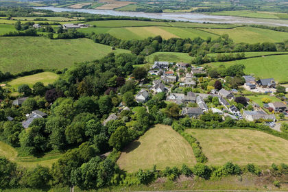 Added on 20/07/2026Building Plot
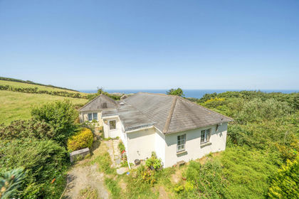
- Price
- Guide Price£285,000
- Size
- 1.21 acres
Added on 20/07/2026House with Land
- Price
- £262,500
Added on 29/01/2026Barn Conversion
- Price
- Guide Price£425,000
- Size
- 5.4 acres
Added on 29/01/2026House with Land
- Price
- Guide Price£350,000
- Size
- 2.5 acres
Near Bolventor, Launceston, St. Neot, Cornwall PL15 7TX England
Added on 25/03/2026Barn Conversion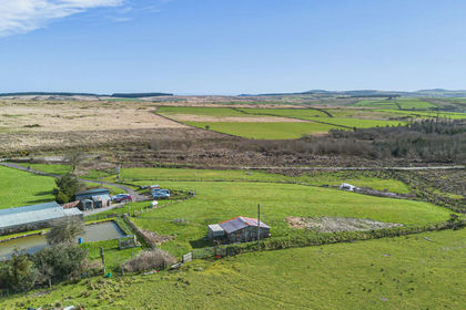
- Price
- Guide Price£350,000
- Size
- 2.5 acres
Middle Lordes Waste, Launceston, PL15, St. Neot, Cornwall PL15 7TX England
Added on 20/03/2026Barn Conversion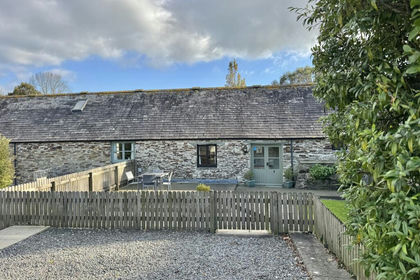 Added on 29/01/2026Barn Conversion