Wisbech Road: Westry, March.
- Land size
- 0.95 acres
Key Features
- For Sale by Private Treaty
- A Prime Residential Development Site with Planning Permission for 4 Dwellings
- And with Potential for a 5th Dwelling
- Extending to an Area of 0.950 of an Acre (0.384 Hectares) (or thereabouts)
- Adjacent to St. Mary's Church on the East Side of Wisbech Road, Westry
- On the Northern Edge of the Market Town of March, Cambridgeshire, PE15 0BA
Description
FOR SALE BY PRIVATE TREATY
A PRIME RESIDENTIAL DEVELOPMENT SITE
with
PLANNING PERMISSION FOR 4 DWELLINGS
and with
ADJOINING AMENITY LAND
EXTENDING TO AN AREA OF
0.950 OF AN ACRE
(0.384 HECTARES)
(or thereabouts)
ADJACENT TO ST. MARY'S CHURCH
on the east side of
WISBECH ROAD, WESTRY
on the northern edge of the market town of
MARCH
CAMBRIDGESHIRE
PE15 0BA
GUIDE PRICE
Offers in the region of £280,000 are invited (Subject to contract)
MARCH, which has a current population of about 23,000, is a busy Fenland market town located on the old course of the River Nene at the junction of the A.141 with the B.1101 about 20 miles east of Peterborough city centre and 11 miles south of Wisbech. Other nearby centres of population include Ely (20 miles) and Huntingdon (22 miles). There is a wide range of amenities within the town itself and this site is a short distance to the north of Hostmoor Avenue retail park with a Tesco Superstore and petrol station, B & M, fast food outlets and the Cobblestones public house.
March is on the railway network with trains to Peterborough, Ely and Stansted Airport which have connecting train services to London (Liverpool Street, St. Pancras and King's Cross).
THIS PRIME RESIDENTIAL DEVELOPMENT SITE lies on the northern outskirts of the town. It extends to an area of 0.950 of an acre (0.384 hectares), or thereabouts, as shown within the boundaries edged red and blue on the attached 1/1,250 scale O.S. plan.
PLANNING PERMISSION was originally granted by Fenland District District Council under Reference F/YR19/1106/F dated the 20th January 2022 for the the erection of 4 dwellings (4 x 2-storey, 2-bedroom) and associated works. A later application to vary conditions 11 (access), 12 (turning and parking) and 21 (condition listing approved plans) was approved on the 31st August 2023 under Reference F/YR22/0835/VOC.
A copy of both of the decision notices is available for inspection at the Agent's office or can be viewed, along with other relevant plans and documents, on Fenland District Council's planning portal.
An application for Permission in Principle for a fifth dwelling on the site edged blue on the plan was withdrawn in August 2024. The application reference was F/TR23/0949/PIP.
TENURE
The property is freehold and forms part of Land Registry Title Number CB335965.
SERVICES
It is understood that all mains services except gas are available for extension into the site, but prospective purchasers should verify this with the utility companies before submitting an offer for the freehold.
VENDOR'S SOLICITOR
Anna Spriggs, Howes Percival, Nene House, 4 Rushmills, Northampton NN4 7YB.
Telephone: . Mobile: . E-mail: anna. .
LOCAL AUTHORITY:
Fenland District Council, County Road, March, Cambridgeshire, PE15 8NQ.
Telephone: . E-mail: Website:
VIEWING
Prospective purchasers wishing to view this site may do so on foot without further authority from the Agents, but should carry a copy of these particulars with them during the course of their inspection and produce them if so requested. Please park responsibly in the car park at the rear of St. Mary's Church Hall.
NOTES
The site areas and the plans included in these particulars are for information and guidance purposes only and their accuracy is not guaranteed.
CONDITIONS OF SALE
The sale of the vacant possession freehold will be subject, inter alia, to the following conditions:
1. Contract.
2. The approval of the purchase price by the Ely Diocesan Board of Finance and compliance with the requirements of the Church Property Measure 2018.
3. The property shall be used for private residential purposes only and not more than four dwellings shall be erected or placed on the land edged red and edged blue on the plan (“the said land”).
4. The dwellings referred to under 3. Above shall be to the type and design approved by the Planning Authority as per Headley Stokes Associates' Drawing Numbers 1752/11/24A; 1752/11/25B and 1752/11/26B.
5. Nothing shall be done, suffered or permitted on the said land which is, or may become, a nuisance annoyance or disturbance to the tenants and authorised occupiers or users of (i) the Vendor's adjoining property edged green on the plan or (ii) the Church Hall or (iii) to the Minister for the time being conducting or the congregation attending divine service or other functions in the adjoining St Mary's Church or the churchyard surrounding the same.
6. No part of the said land nor any existing or future building thereon or on any part thereof shall at any time be used as or for a place of amusement, hotel, tavern, inn or public house nor shall any spirituous or fermented liquors at any time be sold in or upon the said land or any part thereof.
7. The Purchaser will be granted:-
a. the right to construct:-
(i) the access road and footpath to serve the development of the said land along the approximate route marked “A” “B” “D” “E” and edged yellow on the plan;
(ii) the services, drains, sewers, conduits and other conducting media to serve the development of the said land laid through or under the Vendor's adjoining property edged green and yellow on the plan.
8. The reservation by the Vendor of:-
a. all existing rights of light, air, water supply, soil and drainage in respect of its adjoining property; the Church Hall and St. Mary's Church and churchyard;
b. the right for itself and others authorised by it to connect to and use any of the services, drains, sewers, conduits and other conducting media to serve the development of the said land laid through, over or under the Vendor's adjoining property edged green and yellow on the plan.
9. The purchaser shall be responsible for the payment of:-
(i) 75% of the future cost of maintaining, repairing, renewing or replacing the surface of the section of access road shown edged yellow on the plan;
(ii) the whole of the cost of maintaining, repairing, renewing or replacing any of the services, drains, sewers, conduits and other conducting media referred to under 8(b) above which will be, or are, in the exclusive use of the properties to be erected on the said land;
(iii) 75% of the cost of maintaining, repairing, renewing or replacing any of the services, drains, sewers, conduits and other conducting media referred to under 8(b) above which will be, or are, in the shared use of (1) the said land and/or the properties to be erected thereon and (2) the Vendor's adjoining property; the Church Hall and the Church and churchyard, or any or all of the same.
10. The purchaser shall:-
(i) put the boundaries marked “C” “D” and “E” “F” into a stock-proof condition and thereafter maintain the same in a like condition to the reasonable satisfaction of the Vendor;
(ii) erect and thereafter maintain to the reasonable satisfaction of the Vendor stock-proof boundary fences (or such other means of boundary enclosure as may be required by the Local Planning Authority in granting Reserved Matters approval for the development of the said land) along the boundaries marked “F” “G”; “G” “H” and “H” “J” on the plan;
(iii) at his own expense submit and carry out the scheme (including the demarcation of the parking spaces) for the Church car park as required by Condition 20 of Planning Decision Notice F/YR19/1106/F dated 20th January 2022;
11. The boundary enclosure referred to under Condition 9(ii) shall be completed within six months of Reserved Matters approval for the development of the said land (or the next planting season following the consent, whichever is the later).
* * * * * * * *
Map Location
Property details
- Tenure
- Freehold
- Council Tax Band
- Ask Agent
- Date Posted
- 2026-06-15
Utilities & Restrictions
Utilities
- Electricity
- Ask Agent
- Water
- Ask Agent
- Heating
- Ask Agent
- Broadband
- Ask Agent
- Sewerage
- Ask Agent
Rights & Restrictions
- Public Rights of Way
- Ask Agent
- Private Rights of Way
- Ask Agent
- Listed Property
- Ask Agent
- Restrictions
- Ask Agent
Listed status, conservation areas and planning constraints for this location are in the full report.
Property Features
- Accessibility
- Ask Agent
- Parking
- Parking Available
- Garden
- Ask Agent
Beyond the particulars: planning activity, flood history, heritage and ground risks, checked for this exact spot.
Connectivity
Broadband
Fastest speed available at this postcode
5.5 Gbps
Gigabit full fibre · available to 85% of premises
Suitable for
- 4K streaming on every screen
- Full-time home working
- Online gaming & big downloads
Mobile signal
Predicted 4G and 5G signal; indoor signal depends on building materials.
Ofcom Connected Nations postcode-level predictions. Speeds and signal are modelled, not measured, and vary between addresses and providers.
Signal is the easy part. Planning activity, flood history and protected designations here are in the full report.
Nearest Schools
Primary
- Westwood Primary School1.2 milesOfsted: Good *
- Ages
- 4 to 11
- Pupils
- 742
- Type
- Academy converter
- All Saints Interchurch Academy1.3 milesOfsted: Requires improvement *
- Ages
- 5 to 11
- Pupils
- 184
- Type
- Academy converter
- Faith
- Church of England/Roman Catholic
- Burrowmoor Primary Academy1.8 milesOfsted: Inadequate
- Ages
- 2 to 11
- Pupils
- 326
- Type
- Academy converter
- Cavalry Primary School2.4 milesOfsted: Good
- Ages
- 3 to 11
- Pupils
- 407
- Type
- Academy converter
- Guyhirn CofE VC Primary School3.1 milesOfsted: Good
- Ages
- 2 to 11
- Pupils
- 101
- Type
- Academy converter
- Faith
- Church of England
Secondary
- Neale-Wade Academy2.5 milesOfsted report card · Jan 2026
- Ages
- 11 to 18
- Pupils
- 1,130
- Type
- Academy sponsor led
- The Wisbech Academy7.2 milesNo Ofsted rating
- Ages
- 11 to 16
- Pupils
- 205
- Type
- Free schools
- Thomas Clarkson Academy7.4 milesOfsted: Good
- Ages
- 11 to 18
- Pupils
- 1,295
- Type
- Academy sponsor led
- Sir Harry Smith Community College7.6 milesOfsted: Requires improvement *
- Ages
- 11 to 18
- Pupils
- 1,084
- Type
- Academy converter
- Cromwell Community College8.2 milesOfsted: Good
- Ages
- 4 to 18
- Pupils
- 1,539
- Type
- Academy converter
* Latest graded judgement covers quality of education only; no overall grade was issued under the 2024-25 inspection framework.
Distances are straight-line from the advertised location. Source: the national school registers (DfE, Welsh Government, Scottish Government) and Ofsted.
Schools are just the start: sold prices nearby, planning activity and any flood history are in the full report.
Amenities
Supermarket
GP surgery
Pharmacy
Hospital
Straight-line distances from the advertised location. Sources: NHS records, Geolytix supermarket locations, OS Open Greenspace and the national trails registers.
The area stacks up? Now check the location itself: planning nearby, protected designations and past flooding.
Getting Around
Nearest station
Nearest bus stop
Typical drive times
Straight-line distances from the advertised location; drive times are typical free-flow times over OpenStreetMap road data, so allow more at peak. Public transport locations from DfT NaPTAN.
Easy to reach matters. So do planning activity, flood history and ground risks: all in the full report.
Flood Risk
Environment Agency open data, checked around the advertised map pin for the listed acreage. Long-term risk counts flood defences; the planning map's flood zones do not. The map pin for this listing marks the postcode area rather than the exact location, so these readings describe the surrounding area. Provided by LandSale, not the listing agent, and not part of the agent's particulars. Risk varies across a holding, so verify before committing.
Rivers and the sea
Planning map: Flood Zone 1.
Surface water
Not at the pin: mapped about 10 metres away.
These bandings are the summary. Where this location sits on the flood maps, plus planning activity, heritage and ground risks, is in the full report.
Important notice: Information, maps and tags on this page are drawn from the advertising agent's marketing materials or generated automatically. LandSale has not verified them. Relying on these details is at your own risk, always carry out independent checks before committing to a purchase.
LandSale full disclaimer
Marketing information only - not formal particulars. The details on this website are provided for general guidance and do not constitute an offer or contract. Neither LandSale nor the advertising estate/land agent accepts responsibility for any inaccuracy.
1. Source of information
- Listing content: Core description, asking price, tenure, measurements, photographs and planning history originate from the marketing materials of the advertising estate or land agent. LandSale does not author this content and cannot guarantee its accuracy.
- Automated tags & categorisation: Property type, land-use class, acreage bands and similar labels may be applied by machine-learning models. They are intended as a helpful guide only and may not reflect the property's legal status or permitted use.
- Third-party & enriched data layers: Maps, boundary outlines, planning designations, soil reports, broadband coverage and other environmental or location-based insights are licensed from external suppliers. Such data are supplied “as is", may be incomplete or out of date and are subject to change without notice.
2. Verification required
Prospective purchasers must verify critical matters, including but not limited to planning permission, title boundaries, public rights of way, environmental constraints, acreage, services, access and VAT status, through their own inspections, specialist surveys, legal advisers and the selling agent before relying on the information or entering into any contract.
3. No warranty or liability
LandSale gives no warranty, express or implied, as to the accuracy, completeness or fitness for any particular purpose of the information displayed. LandSale shall not be liable for any loss, damage, cost or expense arising directly or indirectly from any use of or reliance on such information, save where liability may not be excluded by law.
4. Updates & feedback
If you believe any detail on this listing is inaccurate, please let us know. We will investigate and, where appropriate, update the listing or notify the agent.
© LandSale | Version 1.3 - August 2026
Listing agent
Jolliffe Daking, Peterborough
37A Broadway, Peterborough, PE1 1SQ
Similar properties for sale
 Added on 25/03/2026Building Plot
- Added on 25/03/2026Building Plot
- Price
- Offers Over£225,000
Added on 04/04/2026Development Land
- Price
- £250,000
- Size
- 1 acres
Plot 9, Hospital Road, Doddington, March, Cambs., PE15, Doddington, Cambridgeshire PE15 England
Added on 22/06/2026Building Plot
- Price
- £280,000
- Size
- 3 acres
Added on 26/08/2026Building Plot Added on 29/01/2026Conversion Land
- Price
- £250,000
- Size
- 0.7 acres
Added on 13/05/2026Building Plot
- Price
- Guide Price£325,000
Former Pub with planning - Horsefair Street, Wisbech PE13, Wisbech, Cambridgeshire PE13 England
Added on 29/01/2026Development Land
- Price
- £225,000
- Size
- 0.33 acres
Lancewood Gardens, Leverington, PE13, Leverington, Cambridgeshire PE13 England
Added on 25/03/2026Building Plot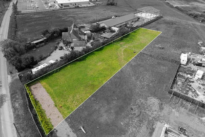
- Price
- Guide Price£225,000
- Size
- 0.52 acres
Chatteris, Cambridgeshire, PE16, Chatteris, Cambridgeshire PE16 England
Added on 22/05/2026Building Plot